Deprecated: Creation of dynamic property Zend_View::$sMode is deprecated in /var/www/stall-frei/htdocs/staging.stall-frei.de/library/vendor/shardj/zf1-future/library/Zend/View/Abstract.php on line 308
Stallplatz oder Offenstall in Sterzhausen
Gesucht wird in "Wollenberg, Sterzhausen, Hessen, Deutschland"
6.331 Einträge
Deprecated: Creation of dynamic property Zend_View::$listObjects is deprecated in /var/www/stall-frei/htdocs/staging.stall-frei.de/library/vendor/shardj/zf1-future/library/Zend/View/Abstract.php on line 308
Gesponsort


Deprecated: Creation of dynamic property Zend_View::$listMode is deprecated in /var/www/stall-frei/htdocs/staging.stall-frei.de/library/vendor/shardj/zf1-future/library/Zend/View/Abstract.php on line 308
Deprecated: Creation of dynamic property Zend_View::$renderedObjects is deprecated in /var/www/stall-frei/htdocs/staging.stall-frei.de/library/vendor/shardj/zf1-future/library/Zend/View/Abstract.php on line 308
Deprecated: Creation of dynamic property Zend_View::$index is deprecated in /var/www/stall-frei/htdocs/staging.stall-frei.de/library/vendor/shardj/zf1-future/library/Zend/View/Abstract.php on line 308
Deprecated: Creation of dynamic property Zend_View::$displayMode is deprecated in /var/www/stall-frei/htdocs/staging.stall-frei.de/library/vendor/shardj/zf1-future/library/Zend/View/Abstract.php on line 308
Deprecated: Creation of dynamic property Zend_View::$remarketingIds is deprecated in /var/www/stall-frei/htdocs/staging.stall-frei.de/library/vendor/shardj/zf1-future/library/Zend/View/Abstract.php on line 308
Deprecated: Creation of dynamic property Zend_View::$listItem is deprecated in /var/www/stall-frei/htdocs/staging.stall-frei.de/library/vendor/shardj/zf1-future/library/Zend/View/Abstract.php on line 308
Deprecated: Creation of dynamic property Zend_View::$object is deprecated in /var/www/stall-frei/htdocs/staging.stall-frei.de/library/vendor/shardj/zf1-future/library/Zend/View/Abstract.php on line 308
Deprecated: Creation of dynamic property Zend_View::$attributes is deprecated in /var/www/stall-frei/htdocs/staging.stall-frei.de/library/vendor/shardj/zf1-future/library/Zend/View/Abstract.php on line 308


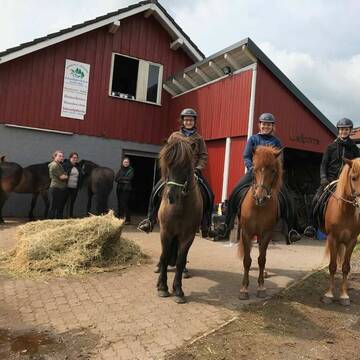
Offenstallplätze und großzügige Paddockboxen
Großseelheim
Birgit Lemmer
@PferdehofLemmer
Freizeitstall
Pferdeausbildung
Vermieten
Hunde willkommen
Krankenbox
Allergikerstall
Hufrehe geeignet
21 weitere...
S


Freie Box auf moderner Reitanlage in Nesselbrunn
Weimar/Lahn
Janina Rüsen-Grosch
@Janina-Grosch
FN-Mitglied
Pferdeausbildung
Vermieten
Führanlage
Paddock
Innenbox
11 weitere...
P+
Deprecated: Creation of dynamic property Zend_View_Helper_Ads::$adLink is deprecated in /var/www/stall-frei/htdocs/staging.stall-frei.de/library/Psf/View/Helper/Ads.php on line 108


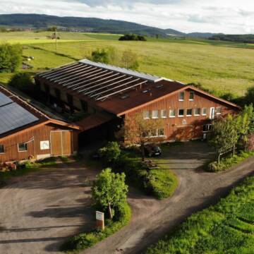
Herdenleben für Ponys und Pferde auf dem WALL-HOF
Marburg
WALL-HOF
@WALL-HOF
Freizeitstall
Gangpferdereiten
Hunde willkommen
Krankenbox
Allergikerstall
Hufrehe geeignet
Offenstall
Paddock Trail
18 weitere...
P

Pferdeboxen frei, Paddock, Wiese, Reitplatz
Dautphetal-Buchenau
C. Schwarz-Nispel
@C.Schwarz-Nispel
Freizeitstall
Vermieten
Hunde willkommen
Paddock
Hufrehe geeignet
10 weitere...
P

Aktivstall Bewegungsstall Vollpension LAG Stall
Wetter
Traumstall-am-Burgwald
@Traumstall-am-Burgwald
Freizeitstall
Geländestrecke
Vermieten
Hunde willkommen
Krankenbox
Gnadenbrothof
Notfallboxen
15 weitere...
P

Futtersack HeuToy, Fressbremse in pink
Mechtersen
STALL-FREIde Marketing
@STALL-FREI-Marketing
Stundenlange Beschäftigung die
Koliken vorbeugt, geringe Staubinhalation mit
steuerbarer Futterentnahme
Islandpferdehof Bornrain
Münchhausen-Simtshausen
Holger-Muth
@Holger-Muth
Freizeitstall
Gangpferdereiten
Hunde willkommen
Krankenbox
Allergikerstall
Hufrehe geeignet
Außenbox mit Paddock
Innenbox
24 weitere...
P
Islandpferdehof Burgwald-Trekking
Münchhausen/OT Simtshaus
Islandpferdehof-Burgwald-Trekking
@Islandpferdehof-Burgwald-Trekk...
FN-Mitglied
Freizeitstall
Vermieten
Longierzirkel/Roundpen
Paddock
Allergikerstall
Gnadenbrothof
31 weitere...
P
Balzerhof
Marburg
Balzerhof
@Balzerhof
Freizeitstall
Westernreiten
Vermieten
Verpachten
Führanlage
Hunde willkommen
Allergikerstall
bedampftes/gewaschenes Heu
30 weitere...
P

Aktivstall (k)einhornland
Dautphetal
Lea Hartmann
@keinhornland
Freizeitstall
Vermieten
Krankenbox
Longierzirkel/Roundpen
Allergikerstall
Hufrehe geeignet
19 weitere...
P
Reitsporthof Hermershausen
Marburg
von-Pritzelwitz-Benjamin
@von-Pritzelwitz-Benjamin
FN-Mitglied
Freizeitstall
Vermieten
Führanlage
Krankenbox
Gnadenbrothof
27 weitere...
P
Deprecated: Creation of dynamic property Zend_View::$pageCount is deprecated in /var/www/stall-frei/htdocs/staging.stall-frei.de/library/vendor/shardj/zf1-future/library/Zend/View/Abstract.php on line 308
Deprecated: Creation of dynamic property Zend_View::$itemCountPerPage is deprecated in /var/www/stall-frei/htdocs/staging.stall-frei.de/library/vendor/shardj/zf1-future/library/Zend/View/Abstract.php on line 308
Deprecated: Creation of dynamic property Zend_View::$first is deprecated in /var/www/stall-frei/htdocs/staging.stall-frei.de/library/vendor/shardj/zf1-future/library/Zend/View/Abstract.php on line 308
Deprecated: Creation of dynamic property Zend_View::$current is deprecated in /var/www/stall-frei/htdocs/staging.stall-frei.de/library/vendor/shardj/zf1-future/library/Zend/View/Abstract.php on line 308
Deprecated: Creation of dynamic property Zend_View::$last is deprecated in /var/www/stall-frei/htdocs/staging.stall-frei.de/library/vendor/shardj/zf1-future/library/Zend/View/Abstract.php on line 308
Deprecated: Creation of dynamic property Zend_View::$next is deprecated in /var/www/stall-frei/htdocs/staging.stall-frei.de/library/vendor/shardj/zf1-future/library/Zend/View/Abstract.php on line 308
Deprecated: Creation of dynamic property Zend_View::$pagesInRange is deprecated in /var/www/stall-frei/htdocs/staging.stall-frei.de/library/vendor/shardj/zf1-future/library/Zend/View/Abstract.php on line 308
Deprecated: Creation of dynamic property Zend_View::$firstPageInRange is deprecated in /var/www/stall-frei/htdocs/staging.stall-frei.de/library/vendor/shardj/zf1-future/library/Zend/View/Abstract.php on line 308
Deprecated: Creation of dynamic property Zend_View::$lastPageInRange is deprecated in /var/www/stall-frei/htdocs/staging.stall-frei.de/library/vendor/shardj/zf1-future/library/Zend/View/Abstract.php on line 308
Deprecated: Creation of dynamic property Zend_View::$currentItemCount is deprecated in /var/www/stall-frei/htdocs/staging.stall-frei.de/library/vendor/shardj/zf1-future/library/Zend/View/Abstract.php on line 308
Deprecated: Creation of dynamic property Zend_View::$totalItemCount is deprecated in /var/www/stall-frei/htdocs/staging.stall-frei.de/library/vendor/shardj/zf1-future/library/Zend/View/Abstract.php on line 308
Deprecated: Creation of dynamic property Zend_View::$firstItemNumber is deprecated in /var/www/stall-frei/htdocs/staging.stall-frei.de/library/vendor/shardj/zf1-future/library/Zend/View/Abstract.php on line 308
Deprecated: Creation of dynamic property Zend_View::$lastItemNumber is deprecated in /var/www/stall-frei/htdocs/staging.stall-frei.de/library/vendor/shardj/zf1-future/library/Zend/View/Abstract.php on line 308
Deprecated: Creation of dynamic property Zend_View::$router is deprecated in /var/www/stall-frei/htdocs/staging.stall-frei.de/library/vendor/shardj/zf1-future/library/Zend/View/Abstract.php on line 308
Deprecated: Creation of dynamic property Zend_View::$urlParams is deprecated in /var/www/stall-frei/htdocs/staging.stall-frei.de/library/vendor/shardj/zf1-future/library/Zend/View/Abstract.php on line 308
Deprecated: Creation of dynamic property Zend_View::$showAds is deprecated in /var/www/stall-frei/htdocs/staging.stall-frei.de/library/vendor/shardj/zf1-future/library/Zend/View/Abstract.php on line 308
Deprecated: Creation of dynamic property Zend_View::$objectIds is deprecated in /var/www/stall-frei/htdocs/staging.stall-frei.de/library/vendor/shardj/zf1-future/library/Zend/View/Abstract.php on line 308
Deprecated: Creation of dynamic property Zend_View::$showNavbar is deprecated in /var/www/stall-frei/htdocs/staging.stall-frei.de/library/vendor/shardj/zf1-future/library/Zend/View/Abstract.php on line 308
Deprecated: Creation of dynamic property Zend_View::$showBreadcrumb is deprecated in /var/www/stall-frei/htdocs/staging.stall-frei.de/library/vendor/shardj/zf1-future/library/Zend/View/Abstract.php on line 308
Deprecated: Creation of dynamic property Zend_View::$showFooter is deprecated in /var/www/stall-frei/htdocs/staging.stall-frei.de/library/vendor/shardj/zf1-future/library/Zend/View/Abstract.php on line 308
Deprecated: Creation of dynamic property Zend_View::$showInternalAds is deprecated in /var/www/stall-frei/htdocs/staging.stall-frei.de/library/vendor/shardj/zf1-future/library/Zend/View/Abstract.php on line 308
Deprecated: Creation of dynamic property Zend_View::$blNoContent is deprecated in /var/www/stall-frei/htdocs/staging.stall-frei.de/library/vendor/shardj/zf1-future/library/Zend/View/Abstract.php on line 308
Deprecated: Creation of dynamic property Zend_View::$sMetaDesc is deprecated in /var/www/stall-frei/htdocs/staging.stall-frei.de/library/vendor/shardj/zf1-future/library/Zend/View/Abstract.php on line 308
Deprecated: Creation of dynamic property Zend_View::$useGmaps is deprecated in /var/www/stall-frei/htdocs/staging.stall-frei.de/library/vendor/shardj/zf1-future/library/Zend/View/Abstract.php on line 308
Deprecated: Creation of dynamic property Zend_View::$touches is deprecated in /var/www/stall-frei/htdocs/staging.stall-frei.de/library/vendor/shardj/zf1-future/library/Zend/View/Abstract.php on line 308
Deprecated: Creation of dynamic property Zend_View::$oProject is deprecated in /var/www/stall-frei/htdocs/staging.stall-frei.de/library/vendor/shardj/zf1-future/library/Zend/View/Abstract.php on line 308
Deprecated: Creation of dynamic property Zend_View::$pageHeadline is deprecated in /var/www/stall-frei/htdocs/staging.stall-frei.de/library/vendor/shardj/zf1-future/library/Zend/View/Abstract.php on line 308
Deprecated: Creation of dynamic property Zend_View::$disableLocationField is deprecated in /var/www/stall-frei/htdocs/staging.stall-frei.de/library/vendor/shardj/zf1-future/library/Zend/View/Abstract.php on line 308
Deprecated: Creation of dynamic property Zend_View::$isSearch is deprecated in /var/www/stall-frei/htdocs/staging.stall-frei.de/library/vendor/shardj/zf1-future/library/Zend/View/Abstract.php on line 308
Deprecated: Creation of dynamic property Zend_View::$pageTitle is deprecated in /var/www/stall-frei/htdocs/staging.stall-frei.de/library/vendor/shardj/zf1-future/library/Zend/View/Abstract.php on line 308
Deprecated: Creation of dynamic property Psf_Form_Element_Text::$class is deprecated in /var/www/stall-frei/htdocs/staging.stall-frei.de/library/vendor/shardj/zf1-future/library/Zend/Form/Element.php on line 874
Deprecated: Creation of dynamic property Psf_Form_Element_Text::$size is deprecated in /var/www/stall-frei/htdocs/staging.stall-frei.de/library/vendor/shardj/zf1-future/library/Zend/Form/Element.php on line 874
Deprecated: Creation of dynamic property Psf_Form_Element_Text::$placeholder is deprecated in /var/www/stall-frei/htdocs/staging.stall-frei.de/library/vendor/shardj/zf1-future/library/Zend/Form/Element.php on line 874
Deprecated: Creation of dynamic property Psf_Form_Element_Hidden::$class is deprecated in /var/www/stall-frei/htdocs/staging.stall-frei.de/library/vendor/shardj/zf1-future/library/Zend/Form/Element.php on line 874
Deprecated: Creation of dynamic property Psf_Form_Element_Hidden::$class is deprecated in /var/www/stall-frei/htdocs/staging.stall-frei.de/library/vendor/shardj/zf1-future/library/Zend/Form/Element.php on line 874
Deprecated: Creation of dynamic property Psf_Form_Element_Hidden::$class is deprecated in /var/www/stall-frei/htdocs/staging.stall-frei.de/library/vendor/shardj/zf1-future/library/Zend/Form/Element.php on line 874
Deprecated: Creation of dynamic property Psf_Form_Element_Hidden::$class is deprecated in /var/www/stall-frei/htdocs/staging.stall-frei.de/library/vendor/shardj/zf1-future/library/Zend/Form/Element.php on line 874
Deprecated: Creation of dynamic property Psf_Form_Element_Select::$class is deprecated in /var/www/stall-frei/htdocs/staging.stall-frei.de/library/vendor/shardj/zf1-future/library/Zend/Form/Element.php on line 874
Deprecated: Creation of dynamic property Psf_Form_Element_Select::$class is deprecated in /var/www/stall-frei/htdocs/staging.stall-frei.de/library/vendor/shardj/zf1-future/library/Zend/Form/Element.php on line 874
Deprecated: Creation of dynamic property Psf_Form_Element_Select::$class is deprecated in /var/www/stall-frei/htdocs/staging.stall-frei.de/library/vendor/shardj/zf1-future/library/Zend/Form/Element.php on line 874
Deprecated: Creation of dynamic property Psf_Form_Element_Select::$class is deprecated in /var/www/stall-frei/htdocs/staging.stall-frei.de/library/vendor/shardj/zf1-future/library/Zend/Form/Element.php on line 874
Deprecated: Creation of dynamic property Psf_Form_Element_Text::$class is deprecated in /var/www/stall-frei/htdocs/staging.stall-frei.de/library/vendor/shardj/zf1-future/library/Zend/Form/Element.php on line 874
Deprecated: Creation of dynamic property Psf_Form_Element_Checkbox::$label is deprecated in /var/www/stall-frei/htdocs/staging.stall-frei.de/library/vendor/shardj/zf1-future/library/Zend/Form/Element.php on line 874
Deprecated: Creation of dynamic property Zend_View::$sort is deprecated in /var/www/stall-frei/htdocs/staging.stall-frei.de/library/vendor/shardj/zf1-future/library/Zend/View/Abstract.php on line 308
Deprecated: Creation of dynamic property Zend_View::$searchLocation is deprecated in /var/www/stall-frei/htdocs/staging.stall-frei.de/library/vendor/shardj/zf1-future/library/Zend/View/Abstract.php on line 308
Deprecated: Creation of dynamic property Zend_View::$locationHint is deprecated in /var/www/stall-frei/htdocs/staging.stall-frei.de/library/vendor/shardj/zf1-future/library/Zend/View/Abstract.php on line 308
Psf_GeoCoder_Abstract::getLocation: Wollenberg Get Location CachedOrLive
Psf_GeoCoder_Abstract::getCachedOrLive: Wollenberg
Psf_GeoCoder_OpenCageData::makeApiRequest: response:
Array
(
[documentation] => https://opencagedata.com/api
[licenses] => Array
(
[0] => Array
(
[name] => see attribution guide
[url] => https://opencagedata.com/credits
)
)
[results] => Array
(
[0] => Array
(
[bounds] => Array
(
[northeast] => Array
(
[lat] => 50.8733892
[lng] => 8.6646915
)
[southwest] => Array
(
[lat] => 50.8732892
[lng] => 8.6645915
)
)
[components] => Array
(
[ISO_3166-1_alpha-2] => DE
[ISO_3166-1_alpha-3] => DEU
[ISO_3166-2] => Array
(
[0] => DE-HE
)
[_category] => natural/water
[_normalized_city] => Sterzhausen
[_type] => peak
[continent] => Europe
[country] => Deutschland
[country_code] => de
[county] => Landkreis Marburg-Biedenkopf
[municipality] => Lahntal
[peak] => Wollenberg
[political_union] => European Union
[state] => Hessen
[state_code] => HE
[village] => Sterzhausen
)
[confidence] => 9
[formatted] => Wollenberg, Sterzhausen, Hessen, Deutschland
[geometry] => Array
(
[lat] => 50.8733392
[lng] => 8.6646415
)
)
[1] => Array
(
[bounds] => Array
(
[northeast] => Array
(
[lat] => 50.5040665
[lng] => 6.5038805
)
[southwest] => Array
(
[lat] => 50.4640665
[lng] => 6.4638805
)
)
[components] => Array
(
[ISO_3166-1_alpha-2] => DE
[ISO_3166-1_alpha-3] => DEU
[ISO_3166-2] => Array
(
[0] => DE-NW
)
[_category] => place
[_normalized_city] => Hellenthal
[_type] => village
[city] => Hellenthal
[continent] => Europe
[country] => Deutschland
[country_code] => de
[county] => Kreis Euskirchen
[political_union] => European Union
[postcode] => 53940
[state] => Nordrhein-Westfalen
[state_code] => NW
[village] => Wollenberg
)
[confidence] => 7
[formatted] => 53940 Wollenberg, Deutschland
[geometry] => Array
(
[lat] => 50.4840665
[lng] => 6.4838805
)
)
[2] => Array
(
[bounds] => Array
(
[northeast] => Array
(
[lat] => 49.2994759
[lng] => 9.0508471
)
[southwest] => Array
(
[lat] => 49.2825401
[lng] => 9.0210198
)
)
[components] => Array
(
[ISO_3166-1_alpha-2] => DE
[ISO_3166-1_alpha-3] => DEU
[ISO_3166-2] => Array
(
[0] => DE-BW
)
[_category] => place
[_normalized_city] => Bad Rappenau
[_type] => village
[continent] => Europe
[country] => Deutschland
[country_code] => de
[county] => Landkreis Heilbronn
[municipality] => VVG der Stadt Bad Rappenau
[political_union] => European Union
[state] => Baden-Württemberg
[state_code] => BW
[town] => Bad Rappenau
[village] => Wollenberg
)
[confidence] => 7
[formatted] => Wollenberg, Baden-Württemberg, Deutschland
[geometry] => Array
(
[lat] => 49.290836
[lng] => 9.0355066
)
)
[3] => Array
(
[bounds] => Array
(
[northeast] => Array
(
[lat] => 52.468713
[lng] => 14.4696295
)
[southwest] => Array
(
[lat] => 52.468613
[lng] => 14.4695295
)
)
[components] => Array
(
[ISO_3166-1_alpha-2] => DE
[ISO_3166-1_alpha-3] => DEU
[ISO_3166-2] => Array
(
[0] => DE-BB
)
[_category] => natural/water
[_normalized_city] => Fichtenhöhe
[_type] => peak
[city] => Fichtenhöhe
[continent] => Europe
[country] => Deutschland
[country_code] => de
[county] => Märkisch-Oderland
[municipality] => Seelow-Land
[peak] => Wollenberg
[political_union] => European Union
[postcode] => 15326
[state] => Brandenburg
[state_code] => BB
)
[confidence] => 9
[formatted] => Wollenberg, 15326 Fichtenhöhe, Deutschland
[geometry] => Array
(
[lat] => 52.468663
[lng] => 14.4695795
)
)
[4] => Array
(
[bounds] => Array
(
[northeast] => Array
(
[lat] => 48.7585362
[lng] => 10.0814819
)
[southwest] => Array
(
[lat] => 48.7584362
[lng] => 10.0813819
)
)
[components] => Array
(
[ISO_3166-1_alpha-2] => DE
[ISO_3166-1_alpha-3] => DEU
[ISO_3166-2] => Array
(
[0] => DE-BW
)
[_category] => natural/water
[_normalized_city] => Essingen
[_type] => peak
[continent] => Europe
[country] => Deutschland
[country_code] => de
[county] => Ostalbkreis
[municipality] => VVG der Stadt Aalen
[peak] => Wollenberg
[political_union] => European Union
[postcode] => 89551
[state] => Baden-Württemberg
[state_code] => BW
[village] => Essingen
)
[confidence] => 9
[formatted] => Wollenberg, 89551 Essingen, Deutschland
[geometry] => Array
(
[lat] => 48.7584862
[lng] => 10.0814319
)
)
[5] => Array
(
[bounds] => Array
(
[northeast] => Array
(
[lat] => 52.750395
[lng] => 13.977493
)
[southwest] => Array
(
[lat] => 52.710395
[lng] => 13.937493
)
)
[components] => Array
(
[ISO_3166-1_alpha-2] => DE
[ISO_3166-1_alpha-3] => DEU
[ISO_3166-2] => Array
(
[0] => DE-BB
)
[_category] => place
[_normalized_city] => Wollenberg
[_type] => village
[continent] => Europe
[country] => Deutschland
[country_code] => de
[county] => Märkisch-Oderland
[municipality] => Höhenland
[political_union] => European Union
[state] => Brandenburg
[state_code] => BB
[village] => Wollenberg
)
[confidence] => 7
[formatted] => Wollenberg, Brandenburg, Deutschland
[geometry] => Array
(
[lat] => 52.730395
[lng] => 13.957493
)
)
[6] => Array
(
[bounds] => Array
(
[northeast] => Array
(
[lat] => 50.9020315
[lng] => 8.7150298
)
[southwest] => Array
(
[lat] => 50.8573995
[lng] => 8.6408546
)
)
[components] => Array
(
[ISO_3166-1_alpha-2] => DE
[ISO_3166-1_alpha-3] => DEU
[ISO_3166-2] => Array
(
[0] => DE-HE
)
[_category] => natural/water
[_normalized_city] => Sterzhausen
[_type] => forest
[continent] => Europe
[country] => Deutschland
[country_code] => de
[county] => Landkreis Marburg-Biedenkopf
[forest] => Wollenberg
[municipality] => Lahntal
[political_union] => European Union
[state] => Hessen
[state_code] => HE
[village] => Sterzhausen
)
[confidence] => 7
[formatted] => Wollenberg, Sterzhausen, Hessen, Deutschland
[geometry] => Array
(
[lat] => 50.8797125
[lng] => 8.6762848
)
)
[7] => Array
(
[bounds] => Array
(
[northeast] => Array
(
[lat] => 48.7689695
[lng] => 10.0955198
)
[southwest] => Array
(
[lat] => 48.7489695
[lng] => 10.0755198
)
)
[components] => Array
(
[ISO_3166-1_alpha-2] => DE
[ISO_3166-1_alpha-3] => DEU
[ISO_3166-2] => Array
(
[0] => DE-BW
)
[_category] => place
[_normalized_city] => Oberkochen
[_type] => hamlet
[continent] => Europe
[country] => Deutschland
[country_code] => de
[county] => Ostalbkreis
[locality] => Wollenberg
[political_union] => European Union
[postcode] => 73447
[state] => Baden-Württemberg
[state_code] => BW
[town] => Oberkochen
)
[confidence] => 8
[formatted] => Wollenberg, 73447 Oberkochen, Deutschland
[geometry] => Array
(
[lat] => 48.7589695
[lng] => 10.0855198
)
)
[8] => Array
(
[bounds] => Array
(
[northeast] => Array
(
[lat] => 50.4867098
[lng] => 6.4893627
)
[southwest] => Array
(
[lat] => 50.4825554
[lng] => 6.4811234
)
)
[components] => Array
(
[ISO_3166-1_alpha-2] => DE
[ISO_3166-1_alpha-3] => DEU
[ISO_3166-2] => Array
(
[0] => DE-NW
)
[_category] => road
[_normalized_city] => Hellenthal
[_type] => road
[city] => Hellenthal
[continent] => Europe
[country] => Deutschland
[country_code] => de
[county] => Kreis Euskirchen
[political_union] => European Union
[postcode] => 53940
[road] => Wollenberg
[road_type] => residential
[state] => Nordrhein-Westfalen
[state_code] => NW
[village] => Wollenberg
)
[confidence] => 9
[formatted] => Wollenberg, 53940 Wollenberg, Deutschland
[geometry] => Array
(
[lat] => 50.4844338
[lng] => 6.4852709
)
)
[9] => Array
(
[bounds] => Array
(
[northeast] => Array
(
[lat] => 49.0759417
[lng] => 9.2022079
)
[southwest] => Array
(
[lat] => 49.0756297
[lng] => 9.2017839
)
)
[components] => Array
(
[ISO_3166-1_alpha-2] => DE
[ISO_3166-1_alpha-3] => DEU
[ISO_3166-2] => Array
(
[0] => DE-BW
)
[_category] => road
[_normalized_city] => Talheim
[_type] => road
[continent] => Europe
[country] => Deutschland
[country_code] => de
[county] => Landkreis Heilbronn
[municipality] => GVV Flein-Talheim
[political_union] => European Union
[postcode] => 74388
[road] => Wollenberg
[road_type] => residential
[state] => Baden-Württemberg
[state_code] => BW
[village] => Talheim
)
[confidence] => 9
[formatted] => Wollenberg, 74388 Talheim, Deutschland
[geometry] => Array
(
[lat] => 49.0758664
[lng] => 9.2020799
)
)
)
[status] => Array
(
[code] => 200
[message] => OK
)
[stay_informed] => Array
(
[blog] => https://blog.opencagedata.com
[mastodon] => https://en.osm.town/@opencage
)
[thanks] => For using an OpenCage API
[timestamp] => Array
(
[created_http] => Sat, 07 Feb 2026 18:01:34 GMT
[created_unix] => 1770487294
)
[total_results] => 10
)
Psf_GeoCoder_Abstract::convertLocationResult
{"documentation":"https:\/\/opencagedata.com\/api","licenses":[{"name":"see attribution guide","url":"https:\/\/opencagedata.com\/credits"}],"results":[{"bounds":{"northeast":{"lat":50.8733892,"lng":8.6646915},"southwest":{"lat":50.8732892,"lng":8.6645915}},"components":{"ISO_3166-1_alpha-2":"DE","ISO_3166-1_alpha-3":"DEU","ISO_3166-2":["DE-HE"],"_category":"natural\/water","_normalized_city":"Sterzhausen","_type":"peak","continent":"Europe","country":"Deutschland","country_code":"de","county":"Landkreis Marburg-Biedenkopf","municipality":"Lahntal","peak":"Wollenberg","political_union":"European Union","state":"Hessen","state_code":"HE","village":"Sterzhausen"},"confidence":9,"formatted":"Wollenberg, Sterzhausen, Hessen, Deutschland","geometry":{"lat":50.8733392,"lng":8.6646415}},{"bounds":{"northeast":{"lat":50.5040665,"lng":6.5038805},"southwest":{"lat":50.4640665,"lng":6.4638805}},"components":{"ISO_3166-1_alpha-2":"DE","ISO_3166-1_alpha-3":"DEU","ISO_3166-2":["DE-NW"],"_category":"place","_normalized_city":"Hellenthal","_type":"village","city":"Hellenthal","continent":"Europe","country":"Deutschland","country_code":"de","county":"Kreis Euskirchen","political_union":"European Union","postcode":"53940","state":"Nordrhein-Westfalen","state_code":"NW","village":"Wollenberg"},"confidence":7,"formatted":"53940 Wollenberg, Deutschland","geometry":{"lat":50.4840665,"lng":6.4838805}},{"bounds":{"northeast":{"lat":49.2994759,"lng":9.0508471},"southwest":{"lat":49.2825401,"lng":9.0210198}},"components":{"ISO_3166-1_alpha-2":"DE","ISO_3166-1_alpha-3":"DEU","ISO_3166-2":["DE-BW"],"_category":"place","_normalized_city":"Bad Rappenau","_type":"village","continent":"Europe","country":"Deutschland","country_code":"de","county":"Landkreis Heilbronn","municipality":"VVG der Stadt Bad Rappenau","political_union":"European Union","state":"Baden-W\u00fcrttemberg","state_code":"BW","town":"Bad Rappenau","village":"Wollenberg"},"confidence":7,"formatted":"Wollenberg, Baden-W\u00fcrttemberg, Deutschland","geometry":{"lat":49.290836,"lng":9.0355066}},{"bounds":{"northeast":{"lat":52.468713,"lng":14.4696295},"southwest":{"lat":52.468613,"lng":14.4695295}},"components":{"ISO_3166-1_alpha-2":"DE","ISO_3166-1_alpha-3":"DEU","ISO_3166-2":["DE-BB"],"_category":"natural\/water","_normalized_city":"Fichtenh\u00f6he","_type":"peak","city":"Fichtenh\u00f6he","continent":"Europe","country":"Deutschland","country_code":"de","county":"M\u00e4rkisch-Oderland","municipality":"Seelow-Land","peak":"Wollenberg","political_union":"European Union","postcode":"15326","state":"Brandenburg","state_code":"BB"},"confidence":9,"formatted":"Wollenberg, 15326 Fichtenh\u00f6he, Deutschland","geometry":{"lat":52.468663,"lng":14.4695795}},{"bounds":{"northeast":{"lat":48.7585362,"lng":10.0814819},"southwest":{"lat":48.7584362,"lng":10.0813819}},"components":{"ISO_3166-1_alpha-2":"DE","ISO_3166-1_alpha-3":"DEU","ISO_3166-2":["DE-BW"],"_category":"natural\/water","_normalized_city":"Essingen","_type":"peak","continent":"Europe","country":"Deutschland","country_code":"de","county":"Ostalbkreis","municipality":"VVG der Stadt Aalen","peak":"Wollenberg","political_union":"European Union","postcode":"89551","state":"Baden-W\u00fcrttemberg","state_code":"BW","village":"Essingen"},"confidence":9,"formatted":"Wollenberg, 89551 Essingen, Deutschland","geometry":{"lat":48.7584862,"lng":10.0814319}},{"bounds":{"northeast":{"lat":52.750395,"lng":13.977493},"southwest":{"lat":52.710395,"lng":13.937493}},"components":{"ISO_3166-1_alpha-2":"DE","ISO_3166-1_alpha-3":"DEU","ISO_3166-2":["DE-BB"],"_category":"place","_normalized_city":"Wollenberg","_type":"village","continent":"Europe","country":"Deutschland","country_code":"de","county":"M\u00e4rkisch-Oderland","municipality":"H\u00f6henland","political_union":"European Union","state":"Brandenburg","state_code":"BB","village":"Wollenberg"},"confidence":7,"formatted":"Wollenberg, Brandenburg, Deutschland","geometry":{"lat":52.730395,"lng":13.957493}},{"bounds":{"northeast":{"lat":50.9020315,"lng":8.7150298},"southwest":{"lat":50.8573995,"lng":8.6408546}},"components":{"ISO_3166-1_alpha-2":"DE","ISO_3166-1_alpha-3":"DEU","ISO_3166-2":["DE-HE"],"_category":"natural\/water","_normalized_city":"Sterzhausen","_type":"forest","continent":"Europe","country":"Deutschland","country_code":"de","county":"Landkreis Marburg-Biedenkopf","forest":"Wollenberg","municipality":"Lahntal","political_union":"European Union","state":"Hessen","state_code":"HE","village":"Sterzhausen"},"confidence":7,"formatted":"Wollenberg, Sterzhausen, Hessen, Deutschland","geometry":{"lat":50.8797125,"lng":8.6762848}},{"bounds":{"northeast":{"lat":48.7689695,"lng":10.0955198},"southwest":{"lat":48.7489695,"lng":10.0755198}},"components":{"ISO_3166-1_alpha-2":"DE","ISO_3166-1_alpha-3":"DEU","ISO_3166-2":["DE-BW"],"_category":"place","_normalized_city":"Oberkochen","_type":"hamlet","continent":"Europe","country":"Deutschland","country_code":"de","county":"Ostalbkreis","locality":"Wollenberg","political_union":"European Union","postcode":"73447","state":"Baden-W\u00fcrttemberg","state_code":"BW","town":"Oberkochen"},"confidence":8,"formatted":"Wollenberg, 73447 Oberkochen, Deutschland","geometry":{"lat":48.7589695,"lng":10.0855198}},{"bounds":{"northeast":{"lat":50.4867098,"lng":6.4893627},"southwest":{"lat":50.4825554,"lng":6.4811234}},"components":{"ISO_3166-1_alpha-2":"DE","ISO_3166-1_alpha-3":"DEU","ISO_3166-2":["DE-NW"],"_category":"road","_normalized_city":"Hellenthal","_type":"road","city":"Hellenthal","continent":"Europe","country":"Deutschland","country_code":"de","county":"Kreis Euskirchen","political_union":"European Union","postcode":"53940","road":"Wollenberg","road_type":"residential","state":"Nordrhein-Westfalen","state_code":"NW","village":"Wollenberg"},"confidence":9,"formatted":"Wollenberg, 53940 Wollenberg, Deutschland","geometry":{"lat":50.4844338,"lng":6.4852709}},{"bounds":{"northeast":{"lat":49.0759417,"lng":9.2022079},"southwest":{"lat":49.0756297,"lng":9.2017839}},"components":{"ISO_3166-1_alpha-2":"DE","ISO_3166-1_alpha-3":"DEU","ISO_3166-2":["DE-BW"],"_category":"road","_normalized_city":"Talheim","_type":"road","continent":"Europe","country":"Deutschland","country_code":"de","county":"Landkreis Heilbronn","municipality":"GVV Flein-Talheim","political_union":"European Union","postcode":"74388","road":"Wollenberg","road_type":"residential","state":"Baden-W\u00fcrttemberg","state_code":"BW","village":"Talheim"},"confidence":9,"formatted":"Wollenberg, 74388 Talheim, Deutschland","geometry":{"lat":49.0758664,"lng":9.2020799}}],"status":{"code":200,"message":"OK"},"stay_informed":{"blog":"https:\/\/blog.opencagedata.com","mastodon":"https:\/\/en.osm.town\/@opencage"},"thanks":"For using an OpenCage API","timestamp":{"created_http":"Sat, 07 Feb 2026 18:01:34 GMT","created_unix":1770487294},"total_results":10}Array
(
[0] => stdClass Object
(
[bounds] => stdClass Object
(
[northeast] => stdClass Object
(
[lat] => 50.8733892
[lng] => 8.6646915
)
[southwest] => stdClass Object
(
[lat] => 50.8732892
[lng] => 8.6645915
)
)
[components] => stdClass Object
(
[ISO_3166-1_alpha-2] => DE
[ISO_3166-1_alpha-3] => DEU
[ISO_3166-2] => Array
(
[0] => DE-HE
)
[_category] => natural/water
[_normalized_city] => Sterzhausen
[_type] => peak
[continent] => Europe
[country] => Deutschland
[country_code] => de
[county] => Landkreis Marburg-Biedenkopf
[municipality] => Lahntal
[peak] => Wollenberg
[political_union] => European Union
[state] => Hessen
[state_code] => HE
[village] => Sterzhausen
)
[confidence] => 9
[formatted] => Wollenberg, Sterzhausen, Hessen, Deutschland
[geometry] => stdClass Object
(
[lat] => 50.8733392
[lng] => 8.6646415
)
)
[1] => stdClass Object
(
[bounds] => stdClass Object
(
[northeast] => stdClass Object
(
[lat] => 50.5040665
[lng] => 6.5038805
)
[southwest] => stdClass Object
(
[lat] => 50.4640665
[lng] => 6.4638805
)
)
[components] => stdClass Object
(
[ISO_3166-1_alpha-2] => DE
[ISO_3166-1_alpha-3] => DEU
[ISO_3166-2] => Array
(
[0] => DE-NW
)
[_category] => place
[_normalized_city] => Hellenthal
[_type] => village
[city] => Hellenthal
[continent] => Europe
[country] => Deutschland
[country_code] => de
[county] => Kreis Euskirchen
[political_union] => European Union
[postcode] => 53940
[state] => Nordrhein-Westfalen
[state_code] => NW
[village] => Wollenberg
)
[confidence] => 7
[formatted] => 53940 Wollenberg, Deutschland
[geometry] => stdClass Object
(
[lat] => 50.4840665
[lng] => 6.4838805
)
)
[2] => stdClass Object
(
[bounds] => stdClass Object
(
[northeast] => stdClass Object
(
[lat] => 49.2994759
[lng] => 9.0508471
)
[southwest] => stdClass Object
(
[lat] => 49.2825401
[lng] => 9.0210198
)
)
[components] => stdClass Object
(
[ISO_3166-1_alpha-2] => DE
[ISO_3166-1_alpha-3] => DEU
[ISO_3166-2] => Array
(
[0] => DE-BW
)
[_category] => place
[_normalized_city] => Bad Rappenau
[_type] => village
[continent] => Europe
[country] => Deutschland
[country_code] => de
[county] => Landkreis Heilbronn
[municipality] => VVG der Stadt Bad Rappenau
[political_union] => European Union
[state] => Baden-Württemberg
[state_code] => BW
[town] => Bad Rappenau
[village] => Wollenberg
)
[confidence] => 7
[formatted] => Wollenberg, Baden-Württemberg, Deutschland
[geometry] => stdClass Object
(
[lat] => 49.290836
[lng] => 9.0355066
)
)
[3] => stdClass Object
(
[bounds] => stdClass Object
(
[northeast] => stdClass Object
(
[lat] => 52.468713
[lng] => 14.4696295
)
[southwest] => stdClass Object
(
[lat] => 52.468613
[lng] => 14.4695295
)
)
[components] => stdClass Object
(
[ISO_3166-1_alpha-2] => DE
[ISO_3166-1_alpha-3] => DEU
[ISO_3166-2] => Array
(
[0] => DE-BB
)
[_category] => natural/water
[_normalized_city] => Fichtenhöhe
[_type] => peak
[city] => Fichtenhöhe
[continent] => Europe
[country] => Deutschland
[country_code] => de
[county] => Märkisch-Oderland
[municipality] => Seelow-Land
[peak] => Wollenberg
[political_union] => European Union
[postcode] => 15326
[state] => Brandenburg
[state_code] => BB
)
[confidence] => 9
[formatted] => Wollenberg, 15326 Fichtenhöhe, Deutschland
[geometry] => stdClass Object
(
[lat] => 52.468663
[lng] => 14.4695795
)
)
[4] => stdClass Object
(
[bounds] => stdClass Object
(
[northeast] => stdClass Object
(
[lat] => 48.7585362
[lng] => 10.0814819
)
[southwest] => stdClass Object
(
[lat] => 48.7584362
[lng] => 10.0813819
)
)
[components] => stdClass Object
(
[ISO_3166-1_alpha-2] => DE
[ISO_3166-1_alpha-3] => DEU
[ISO_3166-2] => Array
(
[0] => DE-BW
)
[_category] => natural/water
[_normalized_city] => Essingen
[_type] => peak
[continent] => Europe
[country] => Deutschland
[country_code] => de
[county] => Ostalbkreis
[municipality] => VVG der Stadt Aalen
[peak] => Wollenberg
[political_union] => European Union
[postcode] => 89551
[state] => Baden-Württemberg
[state_code] => BW
[village] => Essingen
)
[confidence] => 9
[formatted] => Wollenberg, 89551 Essingen, Deutschland
[geometry] => stdClass Object
(
[lat] => 48.7584862
[lng] => 10.0814319
)
)
[5] => stdClass Object
(
[bounds] => stdClass Object
(
[northeast] => stdClass Object
(
[lat] => 52.750395
[lng] => 13.977493
)
[southwest] => stdClass Object
(
[lat] => 52.710395
[lng] => 13.937493
)
)
[components] => stdClass Object
(
[ISO_3166-1_alpha-2] => DE
[ISO_3166-1_alpha-3] => DEU
[ISO_3166-2] => Array
(
[0] => DE-BB
)
[_category] => place
[_normalized_city] => Wollenberg
[_type] => village
[continent] => Europe
[country] => Deutschland
[country_code] => de
[county] => Märkisch-Oderland
[municipality] => Höhenland
[political_union] => European Union
[state] => Brandenburg
[state_code] => BB
[village] => Wollenberg
)
[confidence] => 7
[formatted] => Wollenberg, Brandenburg, Deutschland
[geometry] => stdClass Object
(
[lat] => 52.730395
[lng] => 13.957493
)
)
[6] => stdClass Object
(
[bounds] => stdClass Object
(
[northeast] => stdClass Object
(
[lat] => 50.9020315
[lng] => 8.7150298
)
[southwest] => stdClass Object
(
[lat] => 50.8573995
[lng] => 8.6408546
)
)
[components] => stdClass Object
(
[ISO_3166-1_alpha-2] => DE
[ISO_3166-1_alpha-3] => DEU
[ISO_3166-2] => Array
(
[0] => DE-HE
)
[_category] => natural/water
[_normalized_city] => Sterzhausen
[_type] => forest
[continent] => Europe
[country] => Deutschland
[country_code] => de
[county] => Landkreis Marburg-Biedenkopf
[forest] => Wollenberg
[municipality] => Lahntal
[political_union] => European Union
[state] => Hessen
[state_code] => HE
[village] => Sterzhausen
)
[confidence] => 7
[formatted] => Wollenberg, Sterzhausen, Hessen, Deutschland
[geometry] => stdClass Object
(
[lat] => 50.8797125
[lng] => 8.6762848
)
)
[7] => stdClass Object
(
[bounds] => stdClass Object
(
[northeast] => stdClass Object
(
[lat] => 48.7689695
[lng] => 10.0955198
)
[southwest] => stdClass Object
(
[lat] => 48.7489695
[lng] => 10.0755198
)
)
[components] => stdClass Object
(
[ISO_3166-1_alpha-2] => DE
[ISO_3166-1_alpha-3] => DEU
[ISO_3166-2] => Array
(
[0] => DE-BW
)
[_category] => place
[_normalized_city] => Oberkochen
[_type] => hamlet
[continent] => Europe
[country] => Deutschland
[country_code] => de
[county] => Ostalbkreis
[locality] => Wollenberg
[political_union] => European Union
[postcode] => 73447
[state] => Baden-Württemberg
[state_code] => BW
[town] => Oberkochen
)
[confidence] => 8
[formatted] => Wollenberg, 73447 Oberkochen, Deutschland
[geometry] => stdClass Object
(
[lat] => 48.7589695
[lng] => 10.0855198
)
)
[8] => stdClass Object
(
[bounds] => stdClass Object
(
[northeast] => stdClass Object
(
[lat] => 50.4867098
[lng] => 6.4893627
)
[southwest] => stdClass Object
(
[lat] => 50.4825554
[lng] => 6.4811234
)
)
[components] => stdClass Object
(
[ISO_3166-1_alpha-2] => DE
[ISO_3166-1_alpha-3] => DEU
[ISO_3166-2] => Array
(
[0] => DE-NW
)
[_category] => road
[_normalized_city] => Hellenthal
[_type] => road
[city] => Hellenthal
[continent] => Europe
[country] => Deutschland
[country_code] => de
[county] => Kreis Euskirchen
[political_union] => European Union
[postcode] => 53940
[road] => Wollenberg
[road_type] => residential
[state] => Nordrhein-Westfalen
[state_code] => NW
[village] => Wollenberg
)
[confidence] => 9
[formatted] => Wollenberg, 53940 Wollenberg, Deutschland
[geometry] => stdClass Object
(
[lat] => 50.4844338
[lng] => 6.4852709
)
)
[9] => stdClass Object
(
[bounds] => stdClass Object
(
[northeast] => stdClass Object
(
[lat] => 49.0759417
[lng] => 9.2022079
)
[southwest] => stdClass Object
(
[lat] => 49.0756297
[lng] => 9.2017839
)
)
[components] => stdClass Object
(
[ISO_3166-1_alpha-2] => DE
[ISO_3166-1_alpha-3] => DEU
[ISO_3166-2] => Array
(
[0] => DE-BW
)
[_category] => road
[_normalized_city] => Talheim
[_type] => road
[continent] => Europe
[country] => Deutschland
[country_code] => de
[county] => Landkreis Heilbronn
[municipality] => GVV Flein-Talheim
[political_union] => European Union
[postcode] => 74388
[road] => Wollenberg
[road_type] => residential
[state] => Baden-Württemberg
[state_code] => BW
[village] => Talheim
)
[confidence] => 9
[formatted] => Wollenberg, 74388 Talheim, Deutschland
[geometry] => stdClass Object
(
[lat] => 49.0758664
[lng] => 9.2020799
)
)
)
Psf_GeoCoder_OpenCageData::getKeyMap: 0
stdClass Object
(
    [bounds] => stdClass Object
        (
            [northeast] => stdClass Object
                (
                    [lat] => 50.8733892
                    [lng] => 8.6646915
                )

            [southwest] => stdClass Object
                (
                    [lat] => 50.8732892
                    [lng] => 8.6645915
                )

        )

    [components] => stdClass Object
        (
            [ISO_3166-1_alpha-2] => DE
            [ISO_3166-1_alpha-3] => DEU
            [ISO_3166-2] => Array
                (
                    [0] => DE-HE
                )

            [_category] => natural/water
            [_normalized_city] => Sterzhausen
            [_type] => peak
            [continent] => Europe
            [country] => Deutschland
            [country_code] => de
            [county] => Landkreis Marburg-Biedenkopf
            [municipality] => Lahntal
            [peak] => Wollenberg
            [political_union] => European Union
            [state] => Hessen
            [state_code] => HE
            [village] => Sterzhausen
        )

    [confidence] => 9
    [formatted] => Wollenberg, Sterzhausen, Hessen, Deutschland
    [geometry] => stdClass Object
        (
            [lat] => 50.8733392
            [lng] => 8.6646415
        )

)
Psf_GeoCoder_OpenCageData::getCounty: Marburg-Biedenkopf
Psf_GeoCoder_OpenCageData::addMissingData REFETCH!
Array
(
    [address] => Wollenberg, Sterzhausen, Hessen, Deutschland
    [type] => peak
    [street] =>
    [city] => Sterzhausen
    [county] => Marburg-Biedenkopf
    [state] => Hessen
    [zip] =>
    [country] => Deutschland
    [suburb] =>
    [countrycode] => de
    [latitude] => 50.8733392
    [longitude] => 8.6646415
    [accuracy] => 1
    [confidence] => 9
    [bounds] => stdClass Object
        (
            [northeast] => stdClass Object
                (
                    [lat] => 50.8733892
                    [lng] => 8.6646915
                )

            [southwest] => stdClass Object
                (
                    [lat] => 50.8732892
                    [lng] => 8.6645915
                )

        )

)
reformat!
Array
(
    [address] => Wollenberg, Sterzhausen, Hessen, Deutschland
    [type] => peak
    [street] =>
    [city] => Sterzhausen
    [county] => Marburg-Biedenkopf
    [state] => Hessen
    [zip] =>
    [country] => Deutschland
    [suburb] =>
    [countrycode] => de
    [latitude] => 50.8733392
    [longitude] => 8.6646415
    [accuracy] => 1
    [confidence] => 9
    [bounds] => stdClass Object
        (
            [northeast] => stdClass Object
                (
                    [lat] => 50.8733892
                    [lng] => 8.6646915
                )

            [southwest] => stdClass Object
                (
                    [lat] => 50.8732892
                    [lng] => 8.6645915
                )

        )

    [place] => Sterzhausen, Hessen
    [hash] => b18678bd288e292c7851f0335e61c079
)
Psf_GeoCoder_OpenCageData::getKeyMap: 1
stdClass Object
(
    [bounds] => stdClass Object
        (
            [northeast] => stdClass Object
                (
                    [lat] => 50.5040665
                    [lng] => 6.5038805
                )

            [southwest] => stdClass Object
                (
                    [lat] => 50.4640665
                    [lng] => 6.4638805
                )

        )

    [components] => stdClass Object
        (
            [ISO_3166-1_alpha-2] => DE
            [ISO_3166-1_alpha-3] => DEU
            [ISO_3166-2] => Array
                (
                    [0] => DE-NW
                )

            [_category] => place
            [_normalized_city] => Hellenthal
            [_type] => village
            [city] => Hellenthal
            [continent] => Europe
            [country] => Deutschland
            [country_code] => de
            [county] => Kreis Euskirchen
            [political_union] => European Union
            [postcode] => 53940
            [state] => Nordrhein-Westfalen
            [state_code] => NW
            [village] => Wollenberg
        )

    [confidence] => 7
    [formatted] => 53940 Wollenberg, Deutschland
    [geometry] => stdClass Object
        (
            [lat] => 50.4840665
            [lng] => 6.4838805
        )

)
Psf_GeoCoder_OpenCageData::getCounty: Euskirchen
Psf_GeoCoder_OpenCageData::addMissingData REFETCH!
Array
(
    [address] => 53940 Wollenberg, Deutschland
    [type] => village
    [street] =>
    [city] => Wollenberg
    [county] => Euskirchen
    [state] => Nordrhein-Westfalen
    [zip] => 53940
    [country] => Deutschland
    [suburb] =>
    [countrycode] => de
    [latitude] => 50.4840665
    [longitude] => 6.4838805
    [accuracy] => 1
    [confidence] => 7
    [bounds] => stdClass Object
        (
            [northeast] => stdClass Object
                (
                    [lat] => 50.5040665
                    [lng] => 6.5038805
                )

            [southwest] => stdClass Object
                (
                    [lat] => 50.4640665
                    [lng] => 6.4638805
                )

        )

)
reformat!
Array
(
    [address] => 53940 Wollenberg, Deutschland
    [type] => village
    [street] =>
    [city] => Wollenberg
    [county] => Euskirchen
    [state] => Nordrhein-Westfalen
    [zip] => 53940
    [country] => Deutschland
    [suburb] =>
    [countrycode] => de
    [latitude] => 50.4840665
    [longitude] => 6.4838805
    [accuracy] => 1
    [confidence] => 7
    [bounds] => stdClass Object
        (
            [northeast] => stdClass Object
                (
                    [lat] => 50.5040665
                    [lng] => 6.5038805
                )

            [southwest] => stdClass Object
                (
                    [lat] => 50.4640665
                    [lng] => 6.4638805
                )

        )

    [place] => 53940 Wollenberg, Nordrhein-Westfalen
    [hash] => 5b5a4be55c8969d710dbf035942a9ea9
)
Psf_GeoCoder_OpenCageData::getKeyMap: 2
stdClass Object
(
    [bounds] => stdClass Object
        (
            [northeast] => stdClass Object
                (
                    [lat] => 49.2994759
                    [lng] => 9.0508471
                )

            [southwest] => stdClass Object
                (
                    [lat] => 49.2825401
                    [lng] => 9.0210198
                )

        )

    [components] => stdClass Object
        (
            [ISO_3166-1_alpha-2] => DE
            [ISO_3166-1_alpha-3] => DEU
            [ISO_3166-2] => Array
                (
                    [0] => DE-BW
                )

            [_category] => place
            [_normalized_city] => Bad Rappenau
            [_type] => village
            [continent] => Europe
            [country] => Deutschland
            [country_code] => de
            [county] => Landkreis Heilbronn
            [municipality] => VVG der Stadt Bad Rappenau
            [political_union] => European Union
            [state] => Baden-Württemberg
            [state_code] => BW
            [town] => Bad Rappenau
            [village] => Wollenberg
        )

    [confidence] => 7
    [formatted] => Wollenberg, Baden-Württemberg, Deutschland
    [geometry] => stdClass Object
        (
            [lat] => 49.290836
            [lng] => 9.0355066
        )

)
Psf_GeoCoder_OpenCageData::getCounty: Heilbronn
Psf_GeoCoder_OpenCageData::addMissingData REFETCH!
Array
(
    [address] => Wollenberg, Baden-Württemberg, Deutschland
    [type] => village
    [street] =>
    [city] => Bad Rappenau
    [county] => Heilbronn
    [state] => Baden-Württemberg
    [zip] =>
    [country] => Deutschland
    [suburb] =>
    [countrycode] => de
    [latitude] => 49.290836
    [longitude] => 9.0355066
    [accuracy] => 1
    [confidence] => 7
    [bounds] => stdClass Object
        (
            [northeast] => stdClass Object
                (
                    [lat] => 49.2994759
                    [lng] => 9.0508471
                )

            [southwest] => stdClass Object
                (
                    [lat] => 49.2825401
                    [lng] => 9.0210198
                )

        )

)
reformat!
Array
(
    [address] => Bad Rappenau
    [type] => village
    [street] =>
    [city] => Bad Rappenau
    [county] => Heilbronn
    [state] => Baden-Württemberg
    [zip] =>
    [country] => Deutschland
    [suburb] =>
    [countrycode] => de
    [latitude] => 49.290836
    [longitude] => 9.0355066
    [accuracy] => 1
    [confidence] => 7
    [bounds] => stdClass Object
        (
            [northeast] => stdClass Object
                (
                    [lat] => 49.2994759
                    [lng] => 9.0508471
                )

            [southwest] => stdClass Object
                (
                    [lat] => 49.2825401
                    [lng] => 9.0210198
                )

        )

    [place] => Bad Rappenau, Baden-Württemberg
    [hash] => fa29f5759882a6630f039f828c33fda3
)
Psf_GeoCoder_OpenCageData::getKeyMap: 3
stdClass Object
(
    [bounds] => stdClass Object
        (
            [northeast] => stdClass Object
                (
                    [lat] => 52.468713
                    [lng] => 14.4696295
                )

            [southwest] => stdClass Object
                (
                    [lat] => 52.468613
                    [lng] => 14.4695295
                )

        )

    [components] => stdClass Object
        (
            [ISO_3166-1_alpha-2] => DE
            [ISO_3166-1_alpha-3] => DEU
            [ISO_3166-2] => Array
                (
                    [0] => DE-BB
                )

            [_category] => natural/water
            [_normalized_city] => Fichtenhöhe
            [_type] => peak
            [city] => Fichtenhöhe
            [continent] => Europe
            [country] => Deutschland
            [country_code] => de
            [county] => Märkisch-Oderland
            [municipality] => Seelow-Land
            [peak] => Wollenberg
            [political_union] => European Union
            [postcode] => 15326
            [state] => Brandenburg
            [state_code] => BB
        )

    [confidence] => 9
    [formatted] => Wollenberg, 15326 Fichtenhöhe, Deutschland
    [geometry] => stdClass Object
        (
            [lat] => 52.468663
            [lng] => 14.4695795
        )

)
Psf_GeoCoder_OpenCageData::getCounty: Märkisch-Oderland
Psf_GeoCoder_OpenCageData::addMissingData REFETCH!
Array
(
    [address] => Wollenberg, 15326 Fichtenhöhe, Deutschland
    [type] => peak
    [street] =>
    [city] => Fichtenhöhe
    [county] => Märkisch-Oderland
    [state] => Brandenburg
    [zip] => 15326
    [country] => Deutschland
    [suburb] =>
    [countrycode] => de
    [latitude] => 52.468663
    [longitude] => 14.4695795
    [accuracy] => 1
    [confidence] => 9
    [bounds] => stdClass Object
        (
            [northeast] => stdClass Object
                (
                    [lat] => 52.468713
                    [lng] => 14.4696295
                )

            [southwest] => stdClass Object
                (
                    [lat] => 52.468613
                    [lng] => 14.4695295
                )

        )

)
reformat!
Array
(
    [address] => Wollenberg, 15326 Fichtenhöhe, Deutschland
    [type] => peak
    [street] =>
    [city] => Fichtenhöhe
    [county] => Märkisch-Oderland
    [state] => Brandenburg
    [zip] => 15326
    [country] => Deutschland
    [suburb] =>
    [countrycode] => de
    [latitude] => 52.468663
    [longitude] => 14.4695795
    [accuracy] => 1
    [confidence] => 9
    [bounds] => stdClass Object
        (
            [northeast] => stdClass Object
                (
                    [lat] => 52.468713
                    [lng] => 14.4696295
                )

            [southwest] => stdClass Object
                (
                    [lat] => 52.468613
                    [lng] => 14.4695295
                )

        )

    [place] => 15326 Fichtenhöhe, Brandenburg
    [hash] => d31228fe6a9a6cb619dac8bf739dc7ab
)
Psf_GeoCoder_OpenCageData::getKeyMap: 4
stdClass Object
(
    [bounds] => stdClass Object
        (
            [northeast] => stdClass Object
                (
                    [lat] => 48.7585362
                    [lng] => 10.0814819
                )

            [southwest] => stdClass Object
                (
                    [lat] => 48.7584362
                    [lng] => 10.0813819
                )

        )

    [components] => stdClass Object
        (
            [ISO_3166-1_alpha-2] => DE
            [ISO_3166-1_alpha-3] => DEU
            [ISO_3166-2] => Array
                (
                    [0] => DE-BW
                )

            [_category] => natural/water
            [_normalized_city] => Essingen
            [_type] => peak
            [continent] => Europe
            [country] => Deutschland
            [country_code] => de
            [county] => Ostalbkreis
            [municipality] => VVG der Stadt Aalen
            [peak] => Wollenberg
            [political_union] => European Union
            [postcode] => 89551
            [state] => Baden-Württemberg
            [state_code] => BW
            [village] => Essingen
        )

    [confidence] => 9
    [formatted] => Wollenberg, 89551 Essingen, Deutschland
    [geometry] => stdClass Object
        (
            [lat] => 48.7584862
            [lng] => 10.0814319
        )

)
Psf_GeoCoder_OpenCageData::getCounty: Ostalbkreis
Psf_GeoCoder_OpenCageData::addMissingData REFETCH!
Array
(
    [address] => Wollenberg, 89551 Essingen, Deutschland
    [type] => peak
    [street] =>
    [city] => Essingen
    [county] => Ostalbkreis
    [state] => Baden-Württemberg
    [zip] => 89551
    [country] => Deutschland
    [suburb] =>
    [countrycode] => de
    [latitude] => 48.7584862
    [longitude] => 10.0814319
    [accuracy] => 1
    [confidence] => 9
    [bounds] => stdClass Object
        (
            [northeast] => stdClass Object
                (
                    [lat] => 48.7585362
                    [lng] => 10.0814819
                )

            [southwest] => stdClass Object
                (
                    [lat] => 48.7584362
                    [lng] => 10.0813819
                )

        )

)
reformat!
Array
(
    [address] => Wollenberg, 89551 Essingen, Deutschland
    [type] => peak
    [street] =>
    [city] => Essingen
    [county] => Ostalbkreis
    [state] => Baden-Württemberg
    [zip] => 89551
    [country] => Deutschland
    [suburb] =>
    [countrycode] => de
    [latitude] => 48.7584862
    [longitude] => 10.0814319
    [accuracy] => 1
    [confidence] => 9
    [bounds] => stdClass Object
        (
            [northeast] => stdClass Object
                (
                    [lat] => 48.7585362
                    [lng] => 10.0814819
                )

            [southwest] => stdClass Object
                (
                    [lat] => 48.7584362
                    [lng] => 10.0813819
                )

        )

    [place] => 89551 Essingen, Baden-Württemberg
    [hash] => 2986e7f2d3dac22554ebd5d5d2380bcc
)
Psf_GeoCoder_OpenCageData::getKeyMap: 5
stdClass Object
(
    [bounds] => stdClass Object
        (
            [northeast] => stdClass Object
                (
                    [lat] => 52.750395
                    [lng] => 13.977493
                )

            [southwest] => stdClass Object
                (
                    [lat] => 52.710395
                    [lng] => 13.937493
                )

        )

    [components] => stdClass Object
        (
            [ISO_3166-1_alpha-2] => DE
            [ISO_3166-1_alpha-3] => DEU
            [ISO_3166-2] => Array
                (
                    [0] => DE-BB
                )

            [_category] => place
            [_normalized_city] => Wollenberg
            [_type] => village
            [continent] => Europe
            [country] => Deutschland
            [country_code] => de
            [county] => Märkisch-Oderland
            [municipality] => Höhenland
            [political_union] => European Union
            [state] => Brandenburg
            [state_code] => BB
            [village] => Wollenberg
        )

    [confidence] => 7
    [formatted] => Wollenberg, Brandenburg, Deutschland
    [geometry] => stdClass Object
        (
            [lat] => 52.730395
            [lng] => 13.957493
        )

)
Psf_GeoCoder_OpenCageData::getCounty: Märkisch-Oderland
Psf_GeoCoder_OpenCageData::addMissingData REFETCH!
Array
(
    [address] => Wollenberg, Brandenburg, Deutschland
    [type] => village
    [street] =>
    [city] => Wollenberg
    [county] => Märkisch-Oderland
    [state] => Brandenburg
    [zip] =>
    [country] => Deutschland
    [suburb] =>
    [countrycode] => de
    [latitude] => 52.730395
    [longitude] => 13.957493
    [accuracy] => 1
    [confidence] => 7
    [bounds] => stdClass Object
        (
            [northeast] => stdClass Object
                (
                    [lat] => 52.750395
                    [lng] => 13.977493
                )

            [southwest] => stdClass Object
                (
                    [lat] => 52.710395
                    [lng] => 13.937493
                )

        )

)
reformat!
Array
(
    [address] => Wollenberg, Brandenburg, Deutschland
    [type] => village
    [street] =>
    [city] => Wollenberg
    [county] => Märkisch-Oderland
    [state] => Brandenburg
    [zip] =>
    [country] => Deutschland
    [suburb] =>
    [countrycode] => de
    [latitude] => 52.730395
    [longitude] => 13.957493
    [accuracy] => 1
    [confidence] => 7
    [bounds] => stdClass Object
        (
            [northeast] => stdClass Object
                (
                    [lat] => 52.750395
                    [lng] => 13.977493
                )

            [southwest] => stdClass Object
                (
                    [lat] => 52.710395
                    [lng] => 13.937493
                )

        )

    [place] => Wollenberg, Brandenburg
    [hash] => 8eb9a534a3971eac25587ce53a0d72d6
)
Psf_GeoCoder_OpenCageData::getKeyMap: 6
stdClass Object
(
    [bounds] => stdClass Object
        (
            [northeast] => stdClass Object
                (
                    [lat] => 50.9020315
                    [lng] => 8.7150298
                )

            [southwest] => stdClass Object
                (
                    [lat] => 50.8573995
                    [lng] => 8.6408546
                )

        )

    [components] => stdClass Object
        (
            [ISO_3166-1_alpha-2] => DE
            [ISO_3166-1_alpha-3] => DEU
            [ISO_3166-2] => Array
                (
                    [0] => DE-HE
                )

            [_category] => natural/water
            [_normalized_city] => Sterzhausen
            [_type] => forest
            [continent] => Europe
            [country] => Deutschland
            [country_code] => de
            [county] => Landkreis Marburg-Biedenkopf
            [forest] => Wollenberg
            [municipality] => Lahntal
            [political_union] => European Union
            [state] => Hessen
            [state_code] => HE
            [village] => Sterzhausen
        )

    [confidence] => 7
    [formatted] => Wollenberg, Sterzhausen, Hessen, Deutschland
    [geometry] => stdClass Object
        (
            [lat] => 50.8797125
            [lng] => 8.6762848
        )

)
Psf_GeoCoder_OpenCageData::getCounty: Marburg-Biedenkopf
Psf_GeoCoder_OpenCageData::addMissingData REFETCH!
Array
(
    [address] => Wollenberg, Sterzhausen, Hessen, Deutschland
    [type] => forest
    [street] =>
    [city] => Sterzhausen
    [county] => Marburg-Biedenkopf
    [state] => Hessen
    [zip] =>
    [country] => Deutschland
    [suburb] =>
    [countrycode] => de
    [latitude] => 50.8797125
    [longitude] => 8.6762848
    [accuracy] => 1
    [confidence] => 7
    [bounds] => stdClass Object
        (
            [northeast] => stdClass Object
                (
                    [lat] => 50.9020315
                    [lng] => 8.7150298
                )

            [southwest] => stdClass Object
                (
                    [lat] => 50.8573995
                    [lng] => 8.6408546
                )

        )

)
reformat!
Array
(
    [address] => Wollenberg, Sterzhausen, Hessen, Deutschland
    [type] => forest
    [street] =>
    [city] => Sterzhausen
    [county] => Marburg-Biedenkopf
    [state] => Hessen
    [zip] =>
    [country] => Deutschland
    [suburb] =>
    [countrycode] => de
    [latitude] => 50.8797125
    [longitude] => 8.6762848
    [accuracy] => 1
    [confidence] => 7
    [bounds] => stdClass Object
        (
            [northeast] => stdClass Object
                (
                    [lat] => 50.9020315
                    [lng] => 8.7150298
                )

            [southwest] => stdClass Object
                (
                    [lat] => 50.8573995
                    [lng] => 8.6408546
                )

        )

    [place] => Sterzhausen, Hessen
    [hash] => b18678bd288e292c7851f0335e61c079
)
Psf_GeoCoder_OpenCageData::getKeyMap: 7
stdClass Object
(
    [bounds] => stdClass Object
        (
            [northeast] => stdClass Object
                (
                    [lat] => 48.7689695
                    [lng] => 10.0955198
                )

            [southwest] => stdClass Object
                (
                    [lat] => 48.7489695
                    [lng] => 10.0755198
                )

        )

    [components] => stdClass Object
        (
            [ISO_3166-1_alpha-2] => DE
            [ISO_3166-1_alpha-3] => DEU
            [ISO_3166-2] => Array
                (
                    [0] => DE-BW
                )

            [_category] => place
            [_normalized_city] => Oberkochen
            [_type] => hamlet
            [continent] => Europe
            [country] => Deutschland
            [country_code] => de
            [county] => Ostalbkreis
            [locality] => Wollenberg
            [political_union] => European Union
            [postcode] => 73447
            [state] => Baden-Württemberg
            [state_code] => BW
            [town] => Oberkochen
        )

    [confidence] => 8
    [formatted] => Wollenberg, 73447 Oberkochen, Deutschland
    [geometry] => stdClass Object
        (
            [lat] => 48.7589695
            [lng] => 10.0855198
        )

)
Psf_GeoCoder_OpenCageData::getCounty: Ostalbkreis
Psf_GeoCoder_OpenCageData::addMissingData REFETCH!
Array
(
    [address] => Wollenberg, 73447 Oberkochen, Deutschland
    [type] => hamlet
    [street] =>
    [city] => Oberkochen
    [county] => Ostalbkreis
    [state] => Baden-Württemberg
    [zip] => 73447
    [country] => Deutschland
    [suburb] =>
    [countrycode] => de
    [latitude] => 48.7589695
    [longitude] => 10.0855198
    [accuracy] => 1
    [confidence] => 8
    [bounds] => stdClass Object
        (
            [northeast] => stdClass Object
                (
                    [lat] => 48.7689695
                    [lng] => 10.0955198
                )

            [southwest] => stdClass Object
                (
                    [lat] => 48.7489695
                    [lng] => 10.0755198
                )

        )

)
reformat!
Array
(
    [address] => Wollenberg, 73447 Oberkochen, Deutschland
    [type] => hamlet
    [street] =>
    [city] => Oberkochen
    [county] => Ostalbkreis
    [state] => Baden-Württemberg
    [zip] => 73447
    [country] => Deutschland
    [suburb] =>
    [countrycode] => de
    [latitude] => 48.7589695
    [longitude] => 10.0855198
    [accuracy] => 1
    [confidence] => 8
    [bounds] => stdClass Object
        (
            [northeast] => stdClass Object
                (
                    [lat] => 48.7689695
                    [lng] => 10.0955198
                )

            [southwest] => stdClass Object
                (
                    [lat] => 48.7489695
                    [lng] => 10.0755198
                )

        )

    [place] => 73447 Oberkochen, Baden-Württemberg
    [hash] => a8401fb66ce1dc0a186482430cbb59d3
)
Psf_GeoCoder_OpenCageData::getKeyMap: 8
stdClass Object
(
    [bounds] => stdClass Object
        (
            [northeast] => stdClass Object
                (
                    [lat] => 50.4867098
                    [lng] => 6.4893627
                )

            [southwest] => stdClass Object
                (
                    [lat] => 50.4825554
                    [lng] => 6.4811234
                )

        )

    [components] => stdClass Object
        (
            [ISO_3166-1_alpha-2] => DE
            [ISO_3166-1_alpha-3] => DEU
            [ISO_3166-2] => Array
                (
                    [0] => DE-NW
                )

            [_category] => road
            [_normalized_city] => Hellenthal
            [_type] => road
            [city] => Hellenthal
            [continent] => Europe
            [country] => Deutschland
            [country_code] => de
            [county] => Kreis Euskirchen
            [political_union] => European Union
            [postcode] => 53940
            [road] => Wollenberg
            [road_type] => residential
            [state] => Nordrhein-Westfalen
            [state_code] => NW
            [village] => Wollenberg
        )

    [confidence] => 9
    [formatted] => Wollenberg, 53940 Wollenberg, Deutschland
    [geometry] => stdClass Object
        (
            [lat] => 50.4844338
            [lng] => 6.4852709
        )

)
Psf_GeoCoder_OpenCageData::getCounty: Euskirchen
Psf_GeoCoder_OpenCageData::addMissingData REFETCH!
Array
(
    [address] => Wollenberg, 53940 Wollenberg, Deutschland
    [type] => road
    [street] => Wollenberg
    [city] => Wollenberg
    [county] => Euskirchen
    [state] => Nordrhein-Westfalen
    [zip] => 53940
    [country] => Deutschland
    [suburb] =>
    [countrycode] => de
    [latitude] => 50.4844338
    [longitude] => 6.4852709
    [accuracy] => 1
    [confidence] => 9
    [bounds] => stdClass Object
        (
            [northeast] => stdClass Object
                (
                    [lat] => 50.4867098
                    [lng] => 6.4893627
                )

            [southwest] => stdClass Object
                (
                    [lat] => 50.4825554
                    [lng] => 6.4811234
                )

        )

)
reformat!
Array
(
    [address] => Wollenberg, 53940 Wollenberg, Deutschland
    [type] => road
    [street] => Wollenberg
    [city] => Wollenberg
    [county] => Euskirchen
    [state] => Nordrhein-Westfalen
    [zip] => 53940
    [country] => Deutschland
    [suburb] =>
    [countrycode] => de
    [latitude] => 50.4844338
    [longitude] => 6.4852709
    [accuracy] => 1
    [confidence] => 9
    [bounds] => stdClass Object
        (
            [northeast] => stdClass Object
                (
                    [lat] => 50.4867098
                    [lng] => 6.4893627
                )

            [southwest] => stdClass Object
                (
                    [lat] => 50.4825554
                    [lng] => 6.4811234
                )

        )

    [place] => Wollenberg, 53940 Wollenberg, Nordrhein-Westfalen
    [hash] => 4f4189ae9ab5b67174aa394ead0bb179
)
Psf_GeoCoder_OpenCageData::getKeyMap: 9
stdClass Object
(
    [bounds] => stdClass Object
        (
            [northeast] => stdClass Object
                (
                    [lat] => 49.0759417
                    [lng] => 9.2022079
                )

            [southwest] => stdClass Object
                (
                    [lat] => 49.0756297
                    [lng] => 9.2017839
                )

        )

    [components] => stdClass Object
        (
            [ISO_3166-1_alpha-2] => DE
            [ISO_3166-1_alpha-3] => DEU
            [ISO_3166-2] => Array
                (
                    [0] => DE-BW
                )

            [_category] => road
            [_normalized_city] => Talheim
            [_type] => road
            [continent] => Europe
            [country] => Deutschland
            [country_code] => de
            [county] => Landkreis Heilbronn
            [municipality] => GVV Flein-Talheim
            [political_union] => European Union
            [postcode] => 74388
            [road] => Wollenberg
            [road_type] => residential
            [state] => Baden-Württemberg
            [state_code] => BW
            [village] => Talheim
        )

    [confidence] => 9
    [formatted] => Wollenberg, 74388 Talheim, Deutschland
    [geometry] => stdClass Object
        (
            [lat] => 49.0758664
            [lng] => 9.2020799
        )

)
Psf_GeoCoder_OpenCageData::getCounty: Heilbronn
Psf_GeoCoder_OpenCageData::addMissingData REFETCH!
Array
(
    [address] => Wollenberg, 74388 Talheim, Deutschland
    [type] => road
    [street] => Wollenberg
    [city] => Talheim
    [county] => Heilbronn
    [state] => Baden-Württemberg
    [zip] => 74388
    [country] => Deutschland
    [suburb] =>
    [countrycode] => de
    [latitude] => 49.0758664
    [longitude] => 9.2020799
    [accuracy] => 1
    [confidence] => 9
    [bounds] => stdClass Object
        (
            [northeast] => stdClass Object
                (
                    [lat] => 49.0759417
                    [lng] => 9.2022079
                )

            [southwest] => stdClass Object
                (
                    [lat] => 49.0756297
                    [lng] => 9.2017839
                )

        )

)
reformat!
Array
(
    [address] => Wollenberg, 74388 Talheim, Deutschland
    [type] => road
    [street] => Wollenberg
    [city] => Talheim
    [county] => Heilbronn
    [state] => Baden-Württemberg
    [zip] => 74388
    [country] => Deutschland
    [suburb] =>
    [countrycode] => de
    [latitude] => 49.0758664
    [longitude] => 9.2020799
    [accuracy] => 1
    [confidence] => 9
    [bounds] => stdClass Object
        (
            [northeast] => stdClass Object
                (
                    [lat] => 49.0759417
                    [lng] => 9.2022079
                )

            [southwest] => stdClass Object
                (
                    [lat] => 49.0756297
                    [lng] => 9.2017839
                )

        )

    [place] => Wollenberg, 74388 Talheim, Baden-Württemberg
    [hash] => b7c3e8a040f43987786a4c77093482b3
)
Deprecated: Creation of dynamic property Zend_View::$locationHintStyle is deprecated in /var/www/stall-frei/htdocs/staging.stall-frei.de/library/vendor/shardj/zf1-future/library/Zend/View/Abstract.php on line 308
Deprecated: Creation of dynamic property Zend_View::$adGeoLocation is deprecated in /var/www/stall-frei/htdocs/staging.stall-frei.de/library/vendor/shardj/zf1-future/library/Zend/View/Abstract.php on line 308
Deprecated: Creation of dynamic property Zend_View::$recordCount is deprecated in /var/www/stall-frei/htdocs/staging.stall-frei.de/library/vendor/shardj/zf1-future/library/Zend/View/Abstract.php on line 308
Deprecated: explode(): Passing null to parameter #2 ($string) of type string is deprecated in /var/www/stall-frei/htdocs/staging.stall-frei.de/application/models/SearchAgent.php on line 100
Deprecated: explode(): Passing null to parameter #2 ($string) of type string is deprecated in /var/www/stall-frei/htdocs/staging.stall-frei.de/application/models/SearchAgent.php on line 100
Deprecated: explode(): Passing null to parameter #2 ($string) of type string is deprecated in /var/www/stall-frei/htdocs/staging.stall-frei.de/application/models/SearchAgent.php on line 100
Deprecated: explode(): Passing null to parameter #2 ($string) of type string is deprecated in /var/www/stall-frei/htdocs/staging.stall-frei.de/application/models/SearchAgent.php on line 100
Deprecated: explode(): Passing null to parameter #2 ($string) of type string is deprecated in /var/www/stall-frei/htdocs/staging.stall-frei.de/application/models/SearchAgent.php on line 100
Deprecated: explode(): Passing null to parameter #2 ($string) of type string is deprecated in /var/www/stall-frei/htdocs/staging.stall-frei.de/application/models/SearchAgent.php on line 100
Deprecated: explode(): Passing null to parameter #2 ($string) of type string is deprecated in /var/www/stall-frei/htdocs/staging.stall-frei.de/application/models/SearchAgent.php on line 100
Deprecated: explode(): Passing null to parameter #2 ($string) of type string is deprecated in /var/www/stall-frei/htdocs/staging.stall-frei.de/application/models/SearchAgent.php on line 100
Deprecated: explode(): Passing null to parameter #2 ($string) of type string is deprecated in /var/www/stall-frei/htdocs/staging.stall-frei.de/application/models/SearchAgent.php on line 100
Deprecated: trim(): Passing null to parameter #1 ($string) of type string is deprecated in /var/www/stall-frei/htdocs/staging.stall-frei.de/application/models/Account/Search.php on line 82
Warning: Cannot modify header information - headers already sent by (output started at /var/www/stall-frei/htdocs/staging.stall-frei.de/library/vendor/shardj/zf1-future/library/Zend/View/Abstract.php:308) in /var/www/stall-frei/htdocs/staging.stall-frei.de/application/models/Account/Search.php on line 71
Deprecated: Creation of dynamic property Zend_View::$paginationParams is deprecated in /var/www/stall-frei/htdocs/staging.stall-frei.de/library/vendor/shardj/zf1-future/library/Zend/View/Abstract.php on line 308
Deprecated: Creation of dynamic property Zend_View::$objectPaginator is deprecated in /var/www/stall-frei/htdocs/staging.stall-frei.de/library/vendor/shardj/zf1-future/library/Zend/View/Abstract.php on line 308
Deprecated: Creation of dynamic property Zend_View::$featuredObjects is deprecated in /var/www/stall-frei/htdocs/staging.stall-frei.de/library/vendor/shardj/zf1-future/library/Zend/View/Abstract.php on line 308
Deprecated: Creation of dynamic property Zend_View::$hints is deprecated in /var/www/stall-frei/htdocs/staging.stall-frei.de/library/vendor/shardj/zf1-future/library/Zend/View/Abstract.php on line 308
Deprecated: Creation of dynamic property Zend_View::$attributeHints is deprecated in /var/www/stall-frei/htdocs/staging.stall-frei.de/library/vendor/shardj/zf1-future/library/Zend/View/Abstract.php on line 308
Deprecated: Creation of dynamic property Zend_View::$oSearchForm is deprecated in /var/www/stall-frei/htdocs/staging.stall-frei.de/library/vendor/shardj/zf1-future/library/Zend/View/Abstract.php on line 308