Deprecated: Creation of dynamic property Zend_View::$sMode is deprecated in /var/www/stall-frei/htdocs/staging.stall-frei.de/library/vendor/shardj/zf1-future/library/Zend/View/Abstract.php on line 308
Stallplatz oder Offenstall in Postmoor
Gesucht wird in "21640 Postmoor, Deutschland"
6.330 Einträge
Deprecated: Creation of dynamic property Zend_View::$listObjects is deprecated in /var/www/stall-frei/htdocs/staging.stall-frei.de/library/vendor/shardj/zf1-future/library/Zend/View/Abstract.php on line 308
Gesponsort


Deprecated: Creation of dynamic property Zend_View::$listMode is deprecated in /var/www/stall-frei/htdocs/staging.stall-frei.de/library/vendor/shardj/zf1-future/library/Zend/View/Abstract.php on line 308
Deprecated: Creation of dynamic property Zend_View::$renderedObjects is deprecated in /var/www/stall-frei/htdocs/staging.stall-frei.de/library/vendor/shardj/zf1-future/library/Zend/View/Abstract.php on line 308
Deprecated: Creation of dynamic property Zend_View::$index is deprecated in /var/www/stall-frei/htdocs/staging.stall-frei.de/library/vendor/shardj/zf1-future/library/Zend/View/Abstract.php on line 308
Deprecated: Creation of dynamic property Zend_View::$displayMode is deprecated in /var/www/stall-frei/htdocs/staging.stall-frei.de/library/vendor/shardj/zf1-future/library/Zend/View/Abstract.php on line 308
Deprecated: Creation of dynamic property Zend_View::$remarketingIds is deprecated in /var/www/stall-frei/htdocs/staging.stall-frei.de/library/vendor/shardj/zf1-future/library/Zend/View/Abstract.php on line 308
Deprecated: Creation of dynamic property Zend_View::$listItem is deprecated in /var/www/stall-frei/htdocs/staging.stall-frei.de/library/vendor/shardj/zf1-future/library/Zend/View/Abstract.php on line 308
Deprecated: Creation of dynamic property Zend_View::$object is deprecated in /var/www/stall-frei/htdocs/staging.stall-frei.de/library/vendor/shardj/zf1-future/library/Zend/View/Abstract.php on line 308
Deprecated: Creation of dynamic property Zend_View::$attributes is deprecated in /var/www/stall-frei/htdocs/staging.stall-frei.de/library/vendor/shardj/zf1-future/library/Zend/View/Abstract.php on line 308


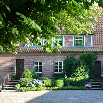
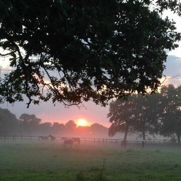
Paddocktrail Anlage in bester Lage
Issendorf
Malin Timm
@Butendieker-Pferdehof
Freizeitstall
Vermieten
Longierzirkel/Roundpen
Parkplatz für Pferdeanhänger
Bewegungsstall
Offenstall
9 weitere...
P+
Schöne Privatanlage in Nottensdorf
Nottensdorf
Hof Alpers-Janke
@Hof Alpers-Janke
Freizeitstall
Geländestrecke
Longierzirkel/Roundpen
Paddock
Gnadenbrothof
Pferdezucht
Außenboxen
Innenbox
12 weitere...
P
Deprecated: Creation of dynamic property Zend_View_Helper_Ads::$adLink is deprecated in /var/www/stall-frei/htdocs/staging.stall-frei.de/library/Psf/View/Helper/Ads.php on line 108

Heu aus neuer Ernte
Mechtersen
STALL-FREIde Marketing
@STALL-FREI-Marketing
Heulage und Pferdeheu aus der neuen Ernte findest du in unserem Futtermarkt
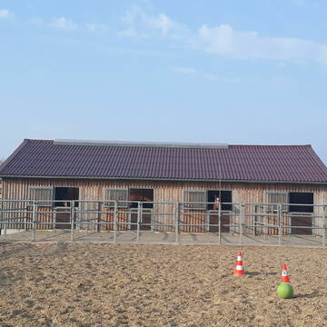
Hof Dorenblick Gerd u. Kristin Höper
Bliedersdorf
Gerd-u-Kristin-Hoeper
@Gerd-u.-Kristin-Hoeper
FN-Mitglied
Freizeitstall
Vermieten
Parkplatz für Pferdeanhänger
Reithalle
Außenboxen
Innenbox
9 weitere...
P


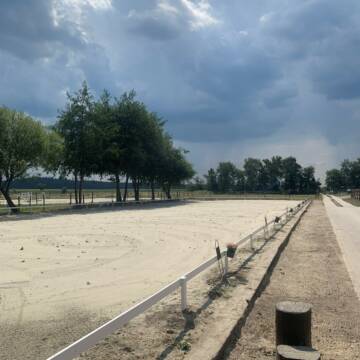
Reiten am Kloevensteen-Familie Ramcke
Pinneberg
Ramcke
@Reitstall_Ramcke
Freizeitstall
Vermieten
Longierzirkel/Roundpen
Paddock
Allergikerstall
Hufrehe geeignet
13 weitere...
S
Paddockbox in Jork-Borstel!
Jork
Quast-Oekoobst
@Quast-Oekoobst
Freizeitstall
Vermieten
Paddock
Reitplatz (z.B. Dressur, Springen, Reining)
Außenbox mit Paddock
5 weitere...
P
Reitsportanlage Brakenhof
Harsefeld
Reitsportanlage-Brakenhof
@Reitsportanlage-Brakenhof
Fahrstall, Kutschwagen
FN-Mitglied
Hunde willkommen
Longierzirkel/Roundpen
Außenboxen
Vollpension
19 weitere...
P

Persönlichkeitsentwicklung mit Pferden
Bad Salzuflen
Katja Dors
@Pferdezeiten
Begleite andere auf ihrem Entwicklungsweg und entdecke die transformative Kraft der pferdegestützten Persönlichkeitsentwicklung !
neu
R

Freier Offenstallplatz
Buxtehude
Silke Peters
@GeesthofPeters
Freizeitstall
Vermieten
Krankenbox
Longierzirkel/Roundpen
Notfallboxen
12 weitere...
P

Reitanlage Holm in 25488 Holm
Holm
Reitanlage-Holm
@Reitanlage-Holm
Freizeitstall
Geländestrecke
Vermieten
Longierzirkel/Roundpen
Ovalbahn
Allergikerstall
Hufrehe geeignet
17 weitere...
P+

Donner Birkenhof
Sauensiek
Dressurausbildung Donner
@DonnerBirkenhof
FN-Mitglied
Freizeitstall
Vermieten
Führanlage
Paddock
Allergikerstall
Gnadenbrothof
21 weitere...
P
Reiterhof Schröder
Schenefeld
Manfred Schröder
@Manfred
Reitlehrer und -unterricht
Paddock
Parkplatz für Pferdeanhänger
Außenbox mit Paddock
Außenboxen
Halbpension
10 weitere...
P+
Deprecated: Creation of dynamic property Zend_View::$pageCount is deprecated in /var/www/stall-frei/htdocs/staging.stall-frei.de/library/vendor/shardj/zf1-future/library/Zend/View/Abstract.php on line 308
Deprecated: Creation of dynamic property Zend_View::$itemCountPerPage is deprecated in /var/www/stall-frei/htdocs/staging.stall-frei.de/library/vendor/shardj/zf1-future/library/Zend/View/Abstract.php on line 308
Deprecated: Creation of dynamic property Zend_View::$first is deprecated in /var/www/stall-frei/htdocs/staging.stall-frei.de/library/vendor/shardj/zf1-future/library/Zend/View/Abstract.php on line 308
Deprecated: Creation of dynamic property Zend_View::$current is deprecated in /var/www/stall-frei/htdocs/staging.stall-frei.de/library/vendor/shardj/zf1-future/library/Zend/View/Abstract.php on line 308
Deprecated: Creation of dynamic property Zend_View::$last is deprecated in /var/www/stall-frei/htdocs/staging.stall-frei.de/library/vendor/shardj/zf1-future/library/Zend/View/Abstract.php on line 308
Deprecated: Creation of dynamic property Zend_View::$next is deprecated in /var/www/stall-frei/htdocs/staging.stall-frei.de/library/vendor/shardj/zf1-future/library/Zend/View/Abstract.php on line 308
Deprecated: Creation of dynamic property Zend_View::$pagesInRange is deprecated in /var/www/stall-frei/htdocs/staging.stall-frei.de/library/vendor/shardj/zf1-future/library/Zend/View/Abstract.php on line 308
Deprecated: Creation of dynamic property Zend_View::$firstPageInRange is deprecated in /var/www/stall-frei/htdocs/staging.stall-frei.de/library/vendor/shardj/zf1-future/library/Zend/View/Abstract.php on line 308
Deprecated: Creation of dynamic property Zend_View::$lastPageInRange is deprecated in /var/www/stall-frei/htdocs/staging.stall-frei.de/library/vendor/shardj/zf1-future/library/Zend/View/Abstract.php on line 308
Deprecated: Creation of dynamic property Zend_View::$currentItemCount is deprecated in /var/www/stall-frei/htdocs/staging.stall-frei.de/library/vendor/shardj/zf1-future/library/Zend/View/Abstract.php on line 308
Deprecated: Creation of dynamic property Zend_View::$totalItemCount is deprecated in /var/www/stall-frei/htdocs/staging.stall-frei.de/library/vendor/shardj/zf1-future/library/Zend/View/Abstract.php on line 308
Deprecated: Creation of dynamic property Zend_View::$firstItemNumber is deprecated in /var/www/stall-frei/htdocs/staging.stall-frei.de/library/vendor/shardj/zf1-future/library/Zend/View/Abstract.php on line 308
Deprecated: Creation of dynamic property Zend_View::$lastItemNumber is deprecated in /var/www/stall-frei/htdocs/staging.stall-frei.de/library/vendor/shardj/zf1-future/library/Zend/View/Abstract.php on line 308
Deprecated: Creation of dynamic property Zend_View::$router is deprecated in /var/www/stall-frei/htdocs/staging.stall-frei.de/library/vendor/shardj/zf1-future/library/Zend/View/Abstract.php on line 308
Deprecated: Creation of dynamic property Zend_View::$urlParams is deprecated in /var/www/stall-frei/htdocs/staging.stall-frei.de/library/vendor/shardj/zf1-future/library/Zend/View/Abstract.php on line 308
Deprecated: Creation of dynamic property Zend_View::$showAds is deprecated in /var/www/stall-frei/htdocs/staging.stall-frei.de/library/vendor/shardj/zf1-future/library/Zend/View/Abstract.php on line 308
Deprecated: Creation of dynamic property Zend_View::$objectIds is deprecated in /var/www/stall-frei/htdocs/staging.stall-frei.de/library/vendor/shardj/zf1-future/library/Zend/View/Abstract.php on line 308
Deprecated: Creation of dynamic property Zend_View::$showNavbar is deprecated in /var/www/stall-frei/htdocs/staging.stall-frei.de/library/vendor/shardj/zf1-future/library/Zend/View/Abstract.php on line 308
Deprecated: Creation of dynamic property Zend_View::$showBreadcrumb is deprecated in /var/www/stall-frei/htdocs/staging.stall-frei.de/library/vendor/shardj/zf1-future/library/Zend/View/Abstract.php on line 308
Deprecated: Creation of dynamic property Zend_View::$showFooter is deprecated in /var/www/stall-frei/htdocs/staging.stall-frei.de/library/vendor/shardj/zf1-future/library/Zend/View/Abstract.php on line 308
Deprecated: Creation of dynamic property Zend_View::$showInternalAds is deprecated in /var/www/stall-frei/htdocs/staging.stall-frei.de/library/vendor/shardj/zf1-future/library/Zend/View/Abstract.php on line 308
Deprecated: Creation of dynamic property Zend_View::$blNoContent is deprecated in /var/www/stall-frei/htdocs/staging.stall-frei.de/library/vendor/shardj/zf1-future/library/Zend/View/Abstract.php on line 308
Deprecated: Creation of dynamic property Zend_View::$sMetaDesc is deprecated in /var/www/stall-frei/htdocs/staging.stall-frei.de/library/vendor/shardj/zf1-future/library/Zend/View/Abstract.php on line 308
Deprecated: Creation of dynamic property Zend_View::$useGmaps is deprecated in /var/www/stall-frei/htdocs/staging.stall-frei.de/library/vendor/shardj/zf1-future/library/Zend/View/Abstract.php on line 308
Deprecated: Creation of dynamic property Zend_View::$touches is deprecated in /var/www/stall-frei/htdocs/staging.stall-frei.de/library/vendor/shardj/zf1-future/library/Zend/View/Abstract.php on line 308
Deprecated: Creation of dynamic property Zend_View::$oProject is deprecated in /var/www/stall-frei/htdocs/staging.stall-frei.de/library/vendor/shardj/zf1-future/library/Zend/View/Abstract.php on line 308
Deprecated: Creation of dynamic property Zend_View::$pageHeadline is deprecated in /var/www/stall-frei/htdocs/staging.stall-frei.de/library/vendor/shardj/zf1-future/library/Zend/View/Abstract.php on line 308
Deprecated: Creation of dynamic property Zend_View::$disableLocationField is deprecated in /var/www/stall-frei/htdocs/staging.stall-frei.de/library/vendor/shardj/zf1-future/library/Zend/View/Abstract.php on line 308
Deprecated: Creation of dynamic property Zend_View::$isSearch is deprecated in /var/www/stall-frei/htdocs/staging.stall-frei.de/library/vendor/shardj/zf1-future/library/Zend/View/Abstract.php on line 308
Deprecated: Creation of dynamic property Zend_View::$pageTitle is deprecated in /var/www/stall-frei/htdocs/staging.stall-frei.de/library/vendor/shardj/zf1-future/library/Zend/View/Abstract.php on line 308
Deprecated: Creation of dynamic property Psf_Form_Element_Text::$class is deprecated in /var/www/stall-frei/htdocs/staging.stall-frei.de/library/vendor/shardj/zf1-future/library/Zend/Form/Element.php on line 874
Deprecated: Creation of dynamic property Psf_Form_Element_Text::$size is deprecated in /var/www/stall-frei/htdocs/staging.stall-frei.de/library/vendor/shardj/zf1-future/library/Zend/Form/Element.php on line 874
Deprecated: Creation of dynamic property Psf_Form_Element_Text::$placeholder is deprecated in /var/www/stall-frei/htdocs/staging.stall-frei.de/library/vendor/shardj/zf1-future/library/Zend/Form/Element.php on line 874
Deprecated: Creation of dynamic property Psf_Form_Element_Hidden::$class is deprecated in /var/www/stall-frei/htdocs/staging.stall-frei.de/library/vendor/shardj/zf1-future/library/Zend/Form/Element.php on line 874
Deprecated: Creation of dynamic property Psf_Form_Element_Hidden::$class is deprecated in /var/www/stall-frei/htdocs/staging.stall-frei.de/library/vendor/shardj/zf1-future/library/Zend/Form/Element.php on line 874
Deprecated: Creation of dynamic property Psf_Form_Element_Hidden::$class is deprecated in /var/www/stall-frei/htdocs/staging.stall-frei.de/library/vendor/shardj/zf1-future/library/Zend/Form/Element.php on line 874
Deprecated: Creation of dynamic property Psf_Form_Element_Hidden::$class is deprecated in /var/www/stall-frei/htdocs/staging.stall-frei.de/library/vendor/shardj/zf1-future/library/Zend/Form/Element.php on line 874
Deprecated: Creation of dynamic property Psf_Form_Element_Select::$class is deprecated in /var/www/stall-frei/htdocs/staging.stall-frei.de/library/vendor/shardj/zf1-future/library/Zend/Form/Element.php on line 874
Deprecated: Creation of dynamic property Psf_Form_Element_Select::$class is deprecated in /var/www/stall-frei/htdocs/staging.stall-frei.de/library/vendor/shardj/zf1-future/library/Zend/Form/Element.php on line 874
Deprecated: Creation of dynamic property Psf_Form_Element_Select::$class is deprecated in /var/www/stall-frei/htdocs/staging.stall-frei.de/library/vendor/shardj/zf1-future/library/Zend/Form/Element.php on line 874
Deprecated: Creation of dynamic property Psf_Form_Element_Select::$class is deprecated in /var/www/stall-frei/htdocs/staging.stall-frei.de/library/vendor/shardj/zf1-future/library/Zend/Form/Element.php on line 874
Deprecated: Creation of dynamic property Psf_Form_Element_Text::$class is deprecated in /var/www/stall-frei/htdocs/staging.stall-frei.de/library/vendor/shardj/zf1-future/library/Zend/Form/Element.php on line 874
Deprecated: Creation of dynamic property Psf_Form_Element_Checkbox::$label is deprecated in /var/www/stall-frei/htdocs/staging.stall-frei.de/library/vendor/shardj/zf1-future/library/Zend/Form/Element.php on line 874
Deprecated: Creation of dynamic property Zend_View::$sort is deprecated in /var/www/stall-frei/htdocs/staging.stall-frei.de/library/vendor/shardj/zf1-future/library/Zend/View/Abstract.php on line 308
Deprecated: Creation of dynamic property Zend_View::$searchLocation is deprecated in /var/www/stall-frei/htdocs/staging.stall-frei.de/library/vendor/shardj/zf1-future/library/Zend/View/Abstract.php on line 308
Deprecated: Creation of dynamic property Zend_View::$locationHint is deprecated in /var/www/stall-frei/htdocs/staging.stall-frei.de/library/vendor/shardj/zf1-future/library/Zend/View/Abstract.php on line 308
Psf_GeoCoder_Abstract::getLocation: Postmoor Get Location CachedOrLive
Psf_GeoCoder_Abstract::getCachedOrLive: Postmoor
Psf_GeoCoder_OpenCageData::makeApiRequest: response:
Array
(
[documentation] => https://opencagedata.com/api
[licenses] => Array
(
[0] => Array
(
[name] => see attribution guide
[url] => https://opencagedata.com/credits
)
)
[results] => Array
(
[0] => Array
(
[bounds] => Array
(
[northeast] => Array
(
[lat] => 53.5180167
[lng] => 9.6079555
)
[southwest] => Array
(
[lat] => 53.4780167
[lng] => 9.5679555
)
)
[components] => Array
(
[ISO_3166-1_alpha-2] => DE
[ISO_3166-1_alpha-3] => DEU
[ISO_3166-2] => Array
(
[0] => DE-NI
)
[_category] => place
[_normalized_city] => Bliedersdorf
[_type] => village
[city] => Bliedersdorf
[continent] => Europe
[country] => Deutschland
[country_code] => de
[county] => Landkreis Stade
[municipality] => Samtgemeinde Horneburg
[political_union] => European Union
[postcode] => 21640
[state] => Niedersachsen
[state_code] => NI
[village] => Postmoor
)
[confidence] => 7
[formatted] => 21640 Postmoor, Deutschland
[geometry] => Array
(
[lat] => 53.4980167
[lng] => 9.5879555
)
)
[1] => Array
(
[bounds] => Array
(
[northeast] => Array
(
[lat] => 52.7089029
[lng] => 10.3749531
)
[southwest] => Array
(
[lat] => 52.7009656
[lng] => 10.3575147
)
)
[components] => Array
(
[ISO_3166-1_alpha-2] => DE
[ISO_3166-1_alpha-3] => DEU
[ISO_3166-2] => Array
(
[0] => DE-NI
)
[_category] => natural/water
[_normalized_city] => Eldingen
[_type] => wetland
[city] => Eldingen
[continent] => Europe
[country] => Deutschland
[country_code] => de
[county] => Landkreis Celle
[municipality] => Samtgemeinde Lachendorf
[political_union] => European Union
[postcode] => 29351
[state] => Niedersachsen
[state_code] => NI
[wetland] => Postmoor
)
[confidence] => 8
[formatted] => Postmoor, 29351 Eldingen, Deutschland
[geometry] => Array
(
[lat] => 52.7049556
[lng] => 10.3657625
)
)
[2] => Array
(
[bounds] => Array
(
[northeast] => Array
(
[lat] => 53.7086896
[lng] => 12.0197377
)
[southwest] => Array
(
[lat] => 53.7078704
[lng] => 12.0185682
)
)
[components] => Array
(
[ISO_3166-1_alpha-2] => DE
[ISO_3166-1_alpha-3] => DEU
[ISO_3166-2] => Array
(
[0] => DE-MV
)
[_category] => natural/water
[_normalized_city] => Mustin
[_type] => wetland
[continent] => Europe
[country] => Deutschland
[country_code] => de
[county] => Ludwigslust-Parchim
[hamlet] => Lenzen
[municipality] => Sternberger Seenlandschaft
[political_union] => European Union
[postcode] => 19406
[state] => Mecklenburg-Vorpommern
[state_code] => MV
[village] => Mustin
[wetland] => Postmoor
)
[confidence] => 9
[formatted] => Postmoor, Lenzen, 19406 Mustin, Deutschland
[geometry] => Array
(
[lat] => 53.7082467
[lng] => 12.0191632
)
)
[3] => Array
(
[bounds] => Array
(
[northeast] => Array
(
[lat] => 53.0692266
[lng] => 9.1882788
)
[southwest] => Array
(
[lat] => 53.0657384
[lng] => 9.1809112
)
)
[components] => Array
(
[ISO_3166-1_alpha-2] => DE
[ISO_3166-1_alpha-3] => DEU
[ISO_3166-2] => Array
(
[0] => DE-NI
)
[_category] => agriculture
[_normalized_city] => Hellwege
[_type] => farmland
[continent] => Europe
[country] => Deutschland
[country_code] => de
[county] => Landkreis Rotenburg (Wümme)
[farmland] => Postmoor
[hamlet] => Auf der Meente
[municipality] => Samtgemeinde Sottrum
[political_union] => European Union
[postcode] => 27367
[state] => Niedersachsen
[state_code] => NI
[village] => Hellwege
)
[confidence] => 9
[formatted] => Postmoor, 27367 Hellwege, Deutschland
[geometry] => Array
(
[lat] => 53.0672921
[lng] => 9.1849784
)
)
[4] => Array
(
[bounds] => Array
(
[northeast] => Array
(
[lat] => 53.7184066
[lng] => 12.0291448
)
[southwest] => Array
(
[lat] => 53.6984066
[lng] => 12.0091448
)
)
[components] => Array
(
[ISO_3166-1_alpha-2] => DE
[ISO_3166-1_alpha-3] => DEU
[ISO_3166-2] => Array
(
[0] => DE-MV
)
[_category] => place
[_normalized_city] => Mustin
[_type] => hamlet
[continent] => Europe
[country] => Deutschland
[country_code] => de
[county] => Ludwigslust-Parchim
[hamlet] => Lenzen
[locality] => Postmoor
[municipality] => Sternberger Seenlandschaft
[political_union] => European Union
[postcode] => 19406
[state] => Mecklenburg-Vorpommern
[state_code] => MV
[village] => Mustin
)
[confidence] => 8
[formatted] => Lenzen, 19406 Mustin, Deutschland
[geometry] => Array
(
[lat] => 53.7084066
[lng] => 12.0191448
)
)
[5] => Array
(
[bounds] => Array
(
[northeast] => Array
(
[lat] => 53.5000432
[lng] => 9.5887336
)
[southwest] => Array
(
[lat] => 53.4977938
[lng] => 9.5853632
)
)
[components] => Array
(
[ISO_3166-1_alpha-2] => DE
[ISO_3166-1_alpha-3] => DEU
[ISO_3166-2] => Array
(
[0] => DE-NI
)
[_category] => road
[_normalized_city] => Bliedersdorf
[_type] => road
[city] => Bliedersdorf
[continent] => Europe
[country] => Deutschland
[country_code] => de
[county] => Landkreis Stade
[municipality] => Samtgemeinde Horneburg
[political_union] => European Union
[postcode] => 21640
[road] => Postmoor
[road_type] => tertiary
[state] => Niedersachsen
[state_code] => NI
[village] => Postmoor
)
[confidence] => 9
[formatted] => Postmoor, 21640 Postmoor, Deutschland
[geometry] => Array
(
[lat] => 53.498893
[lng] => 9.5870681
)
)
[6] => Array
(
[bounds] => Array
(
[northeast] => Array
(
[lat] => 53.0659677
[lng] => 9.1900537
)
[southwest] => Array
(
[lat] => 53.0655546
[lng] => 9.1839012
)
)
[components] => Array
(
[ISO_3166-1_alpha-2] => DE
[ISO_3166-1_alpha-3] => DEU
[ISO_3166-2] => Array
(
[0] => DE-NI
)
[_category] => road
[_normalized_city] => Hellwege
[_type] => road
[continent] => Europe
[country] => Deutschland
[country_code] => de
[county] => Landkreis Rotenburg (Wümme)
[municipality] => Samtgemeinde Sottrum
[political_union] => European Union
[postcode] => 27367
[road] => Postmoor
[road_type] => track
[state] => Niedersachsen
[state_code] => NI
[village] => Hellwege
)
[confidence] => 9
[formatted] => Postmoor, 27367 Hellwege, Deutschland
[geometry] => Array
(
[lat] => 53.0657612
[lng] => 9.1869775
)
)
[7] => Array
(
[bounds] => Array
(
[northeast] => Array
(
[lat] => 53.4983583
[lng] => 9.5885961
)
[southwest] => Array
(
[lat] => 53.4980259
[lng] => 9.587416
)
)
[components] => Array
(
[ISO_3166-1_alpha-2] => DE
[ISO_3166-1_alpha-3] => DEU
[ISO_3166-2] => Array
(
[0] => DE-NI
)
[_category] => road
[_normalized_city] => Bliedersdorf
[_type] => road
[city] => Bliedersdorf
[continent] => Europe
[country] => Deutschland
[country_code] => de
[county] => Landkreis Stade
[municipality] => Samtgemeinde Horneburg
[political_union] => European Union
[postcode] => 21640
[road] => Töfenkamp
[road_type] => residential
[state] => Niedersachsen
[state_code] => NI
[village] => Postmoor
)
[confidence] => 9
[formatted] => Töfenkamp, 21640 Postmoor, Deutschland
[geometry] => Array
(
[lat] => 53.4982747
[lng] => 9.5879462
)
)
[8] => Array
(
[bounds] => Array
(
[northeast] => Array
(
[lat] => 53.4998215
[lng] => 9.5888657
)
[southwest] => Array
(
[lat] => 53.4978004
[lng] => 9.5882924
)
)
[components] => Array
(
[ISO_3166-1_alpha-2] => DE
[ISO_3166-1_alpha-3] => DEU
[ISO_3166-2] => Array
(
[0] => DE-NI
)
[_category] => road
[_normalized_city] => Nottensdorf
[_type] => road
[city] => Nottensdorf
[continent] => Europe
[country] => Deutschland
[country_code] => de
[county] => Landkreis Stade
[municipality] => Samtgemeinde Horneburg
[political_union] => European Union
[postcode] => 21640
[road] => Töfenkamp
[road_type] => residential
[state] => Niedersachsen
[state_code] => NI
)
[confidence] => 9
[formatted] => Töfenkamp, 21640 Nottensdorf, Deutschland
[geometry] => Array
(
[lat] => 53.4985189
[lng] => 9.5886772
)
)
[9] => Array
(
[components] => Array
(
[ISO_3166-1_alpha-2] => FR
[ISO_3166-1_alpha-3] => FRA
[ISO_3166-2] => Array
(
[0] => FR-ARA
[1] => FR-63
)
[_category] => road
[_normalized_city] => Clerlande
[_type] => road
[city] => Clerlande
[continent] => Europe
[country] => France
[country_code] => fr
[county] => Puy-de-Dôme
[local_authority] => Communauté d'agglomération Riom Limagne et Volcans
[political_union] => European Union
[postcode] => 63720
[road] => Route de Pontmort
[state] => Auvergne-Rhône-Alpes
[state_code] => ARA
)
[confidence] => 2
[formatted] => Route de Pontmort, 63720 Clerlande, France
[geometry] => Array
(
[lat] => 45.919065
[lng] => 3.190224
)
)
)
[status] => Array
(
[code] => 200
[message] => OK
)
[stay_informed] => Array
(
[blog] => https://blog.opencagedata.com
[mastodon] => https://en.osm.town/@opencage
)
[thanks] => For using an OpenCage API
[timestamp] => Array
(
[created_http] => Sun, 08 Feb 2026 11:32:22 GMT
[created_unix] => 1770550342
)
[total_results] => 10
)
Psf_GeoCoder_Abstract::convertLocationResult
{"documentation":"https:\/\/opencagedata.com\/api","licenses":[{"name":"see attribution guide","url":"https:\/\/opencagedata.com\/credits"}],"results":[{"bounds":{"northeast":{"lat":53.5180167,"lng":9.6079555},"southwest":{"lat":53.4780167,"lng":9.5679555}},"components":{"ISO_3166-1_alpha-2":"DE","ISO_3166-1_alpha-3":"DEU","ISO_3166-2":["DE-NI"],"_category":"place","_normalized_city":"Bliedersdorf","_type":"village","city":"Bliedersdorf","continent":"Europe","country":"Deutschland","country_code":"de","county":"Landkreis Stade","municipality":"Samtgemeinde Horneburg","political_union":"European Union","postcode":"21640","state":"Niedersachsen","state_code":"NI","village":"Postmoor"},"confidence":7,"formatted":"21640 Postmoor, Deutschland","geometry":{"lat":53.4980167,"lng":9.5879555}},{"bounds":{"northeast":{"lat":52.7089029,"lng":10.3749531},"southwest":{"lat":52.7009656,"lng":10.3575147}},"components":{"ISO_3166-1_alpha-2":"DE","ISO_3166-1_alpha-3":"DEU","ISO_3166-2":["DE-NI"],"_category":"natural\/water","_normalized_city":"Eldingen","_type":"wetland","city":"Eldingen","continent":"Europe","country":"Deutschland","country_code":"de","county":"Landkreis Celle","municipality":"Samtgemeinde Lachendorf","political_union":"European Union","postcode":"29351","state":"Niedersachsen","state_code":"NI","wetland":"Postmoor"},"confidence":8,"formatted":"Postmoor, 29351 Eldingen, Deutschland","geometry":{"lat":52.7049556,"lng":10.3657625}},{"bounds":{"northeast":{"lat":53.7086896,"lng":12.0197377},"southwest":{"lat":53.7078704,"lng":12.0185682}},"components":{"ISO_3166-1_alpha-2":"DE","ISO_3166-1_alpha-3":"DEU","ISO_3166-2":["DE-MV"],"_category":"natural\/water","_normalized_city":"Mustin","_type":"wetland","continent":"Europe","country":"Deutschland","country_code":"de","county":"Ludwigslust-Parchim","hamlet":"Lenzen","municipality":"Sternberger Seenlandschaft","political_union":"European Union","postcode":"19406","state":"Mecklenburg-Vorpommern","state_code":"MV","village":"Mustin","wetland":"Postmoor"},"confidence":9,"formatted":"Postmoor, Lenzen, 19406 Mustin, Deutschland","geometry":{"lat":53.7082467,"lng":12.0191632}},{"bounds":{"northeast":{"lat":53.0692266,"lng":9.1882788},"southwest":{"lat":53.0657384,"lng":9.1809112}},"components":{"ISO_3166-1_alpha-2":"DE","ISO_3166-1_alpha-3":"DEU","ISO_3166-2":["DE-NI"],"_category":"agriculture","_normalized_city":"Hellwege","_type":"farmland","continent":"Europe","country":"Deutschland","country_code":"de","county":"Landkreis Rotenburg (W\u00fcmme)","farmland":"Postmoor","hamlet":"Auf der Meente","municipality":"Samtgemeinde Sottrum","political_union":"European Union","postcode":"27367","state":"Niedersachsen","state_code":"NI","village":"Hellwege"},"confidence":9,"formatted":"Postmoor, 27367 Hellwege, Deutschland","geometry":{"lat":53.0672921,"lng":9.1849784}},{"bounds":{"northeast":{"lat":53.7184066,"lng":12.0291448},"southwest":{"lat":53.6984066,"lng":12.0091448}},"components":{"ISO_3166-1_alpha-2":"DE","ISO_3166-1_alpha-3":"DEU","ISO_3166-2":["DE-MV"],"_category":"place","_normalized_city":"Mustin","_type":"hamlet","continent":"Europe","country":"Deutschland","country_code":"de","county":"Ludwigslust-Parchim","hamlet":"Lenzen","locality":"Postmoor","municipality":"Sternberger Seenlandschaft","political_union":"European Union","postcode":"19406","state":"Mecklenburg-Vorpommern","state_code":"MV","village":"Mustin"},"confidence":8,"formatted":"Lenzen, 19406 Mustin, Deutschland","geometry":{"lat":53.7084066,"lng":12.0191448}},{"bounds":{"northeast":{"lat":53.5000432,"lng":9.5887336},"southwest":{"lat":53.4977938,"lng":9.5853632}},"components":{"ISO_3166-1_alpha-2":"DE","ISO_3166-1_alpha-3":"DEU","ISO_3166-2":["DE-NI"],"_category":"road","_normalized_city":"Bliedersdorf","_type":"road","city":"Bliedersdorf","continent":"Europe","country":"Deutschland","country_code":"de","county":"Landkreis Stade","municipality":"Samtgemeinde Horneburg","political_union":"European Union","postcode":"21640","road":"Postmoor","road_type":"tertiary","state":"Niedersachsen","state_code":"NI","village":"Postmoor"},"confidence":9,"formatted":"Postmoor, 21640 Postmoor, Deutschland","geometry":{"lat":53.498893,"lng":9.5870681}},{"bounds":{"northeast":{"lat":53.0659677,"lng":9.1900537},"southwest":{"lat":53.0655546,"lng":9.1839012}},"components":{"ISO_3166-1_alpha-2":"DE","ISO_3166-1_alpha-3":"DEU","ISO_3166-2":["DE-NI"],"_category":"road","_normalized_city":"Hellwege","_type":"road","continent":"Europe","country":"Deutschland","country_code":"de","county":"Landkreis Rotenburg (W\u00fcmme)","municipality":"Samtgemeinde Sottrum","political_union":"European Union","postcode":"27367","road":"Postmoor","road_type":"track","state":"Niedersachsen","state_code":"NI","village":"Hellwege"},"confidence":9,"formatted":"Postmoor, 27367 Hellwege, Deutschland","geometry":{"lat":53.0657612,"lng":9.1869775}},{"bounds":{"northeast":{"lat":53.4983583,"lng":9.5885961},"southwest":{"lat":53.4980259,"lng":9.587416}},"components":{"ISO_3166-1_alpha-2":"DE","ISO_3166-1_alpha-3":"DEU","ISO_3166-2":["DE-NI"],"_category":"road","_normalized_city":"Bliedersdorf","_type":"road","city":"Bliedersdorf","continent":"Europe","country":"Deutschland","country_code":"de","county":"Landkreis Stade","municipality":"Samtgemeinde Horneburg","political_union":"European Union","postcode":"21640","road":"T\u00f6fenkamp","road_type":"residential","state":"Niedersachsen","state_code":"NI","village":"Postmoor"},"confidence":9,"formatted":"T\u00f6fenkamp, 21640 Postmoor, Deutschland","geometry":{"lat":53.4982747,"lng":9.5879462}},{"bounds":{"northeast":{"lat":53.4998215,"lng":9.5888657},"southwest":{"lat":53.4978004,"lng":9.5882924}},"components":{"ISO_3166-1_alpha-2":"DE","ISO_3166-1_alpha-3":"DEU","ISO_3166-2":["DE-NI"],"_category":"road","_normalized_city":"Nottensdorf","_type":"road","city":"Nottensdorf","continent":"Europe","country":"Deutschland","country_code":"de","county":"Landkreis Stade","municipality":"Samtgemeinde Horneburg","political_union":"European Union","postcode":"21640","road":"T\u00f6fenkamp","road_type":"residential","state":"Niedersachsen","state_code":"NI"},"confidence":9,"formatted":"T\u00f6fenkamp, 21640 Nottensdorf, Deutschland","geometry":{"lat":53.4985189,"lng":9.5886772}},{"components":{"ISO_3166-1_alpha-2":"FR","ISO_3166-1_alpha-3":"FRA","ISO_3166-2":["FR-ARA","FR-63"],"_category":"road","_normalized_city":"Clerlande","_type":"road","city":"Clerlande","continent":"Europe","country":"France","country_code":"fr","county":"Puy-de-D\u00f4me","local_authority":"Communaut\u00e9 d'agglom\u00e9ration Riom Limagne et Volcans","political_union":"European Union","postcode":"63720","road":"Route de Pontmort","state":"Auvergne-Rh\u00f4ne-Alpes","state_code":"ARA"},"confidence":2,"formatted":"Route de Pontmort, 63720 Clerlande, France","geometry":{"lat":45.919065,"lng":3.190224}}],"status":{"code":200,"message":"OK"},"stay_informed":{"blog":"https:\/\/blog.opencagedata.com","mastodon":"https:\/\/en.osm.town\/@opencage"},"thanks":"For using an OpenCage API","timestamp":{"created_http":"Sun, 08 Feb 2026 11:32:22 GMT","created_unix":1770550342},"total_results":10}Array
(
[0] => stdClass Object
(
[bounds] => stdClass Object
(
[northeast] => stdClass Object
(
[lat] => 53.5180167
[lng] => 9.6079555
)
[southwest] => stdClass Object
(
[lat] => 53.4780167
[lng] => 9.5679555
)
)
[components] => stdClass Object
(
[ISO_3166-1_alpha-2] => DE
[ISO_3166-1_alpha-3] => DEU
[ISO_3166-2] => Array
(
[0] => DE-NI
)
[_category] => place
[_normalized_city] => Bliedersdorf
[_type] => village
[city] => Bliedersdorf
[continent] => Europe
[country] => Deutschland
[country_code] => de
[county] => Landkreis Stade
[municipality] => Samtgemeinde Horneburg
[political_union] => European Union
[postcode] => 21640
[state] => Niedersachsen
[state_code] => NI
[village] => Postmoor
)
[confidence] => 7
[formatted] => 21640 Postmoor, Deutschland
[geometry] => stdClass Object
(
[lat] => 53.4980167
[lng] => 9.5879555
)
)
[1] => stdClass Object
(
[bounds] => stdClass Object
(
[northeast] => stdClass Object
(
[lat] => 52.7089029
[lng] => 10.3749531
)
[southwest] => stdClass Object
(
[lat] => 52.7009656
[lng] => 10.3575147
)
)
[components] => stdClass Object
(
[ISO_3166-1_alpha-2] => DE
[ISO_3166-1_alpha-3] => DEU
[ISO_3166-2] => Array
(
[0] => DE-NI
)
[_category] => natural/water
[_normalized_city] => Eldingen
[_type] => wetland
[city] => Eldingen
[continent] => Europe
[country] => Deutschland
[country_code] => de
[county] => Landkreis Celle
[municipality] => Samtgemeinde Lachendorf
[political_union] => European Union
[postcode] => 29351
[state] => Niedersachsen
[state_code] => NI
[wetland] => Postmoor
)
[confidence] => 8
[formatted] => Postmoor, 29351 Eldingen, Deutschland
[geometry] => stdClass Object
(
[lat] => 52.7049556
[lng] => 10.3657625
)
)
[2] => stdClass Object
(
[bounds] => stdClass Object
(
[northeast] => stdClass Object
(
[lat] => 53.7086896
[lng] => 12.0197377
)
[southwest] => stdClass Object
(
[lat] => 53.7078704
[lng] => 12.0185682
)
)
[components] => stdClass Object
(
[ISO_3166-1_alpha-2] => DE
[ISO_3166-1_alpha-3] => DEU
[ISO_3166-2] => Array
(
[0] => DE-MV
)
[_category] => natural/water
[_normalized_city] => Mustin
[_type] => wetland
[continent] => Europe
[country] => Deutschland
[country_code] => de
[county] => Ludwigslust-Parchim
[hamlet] => Lenzen
[municipality] => Sternberger Seenlandschaft
[political_union] => European Union
[postcode] => 19406
[state] => Mecklenburg-Vorpommern
[state_code] => MV
[village] => Mustin
[wetland] => Postmoor
)
[confidence] => 9
[formatted] => Postmoor, Lenzen, 19406 Mustin, Deutschland
[geometry] => stdClass Object
(
[lat] => 53.7082467
[lng] => 12.0191632
)
)
[3] => stdClass Object
(
[bounds] => stdClass Object
(
[northeast] => stdClass Object
(
[lat] => 53.0692266
[lng] => 9.1882788
)
[southwest] => stdClass Object
(
[lat] => 53.0657384
[lng] => 9.1809112
)
)
[components] => stdClass Object
(
[ISO_3166-1_alpha-2] => DE
[ISO_3166-1_alpha-3] => DEU
[ISO_3166-2] => Array
(
[0] => DE-NI
)
[_category] => agriculture
[_normalized_city] => Hellwege
[_type] => farmland
[continent] => Europe
[country] => Deutschland
[country_code] => de
[county] => Landkreis Rotenburg (Wümme)
[farmland] => Postmoor
[hamlet] => Auf der Meente
[municipality] => Samtgemeinde Sottrum
[political_union] => European Union
[postcode] => 27367
[state] => Niedersachsen
[state_code] => NI
[village] => Hellwege
)
[confidence] => 9
[formatted] => Postmoor, 27367 Hellwege, Deutschland
[geometry] => stdClass Object
(
[lat] => 53.0672921
[lng] => 9.1849784
)
)
[4] => stdClass Object
(
[bounds] => stdClass Object
(
[northeast] => stdClass Object
(
[lat] => 53.7184066
[lng] => 12.0291448
)
[southwest] => stdClass Object
(
[lat] => 53.6984066
[lng] => 12.0091448
)
)
[components] => stdClass Object
(
[ISO_3166-1_alpha-2] => DE
[ISO_3166-1_alpha-3] => DEU
[ISO_3166-2] => Array
(
[0] => DE-MV
)
[_category] => place
[_normalized_city] => Mustin
[_type] => hamlet
[continent] => Europe
[country] => Deutschland
[country_code] => de
[county] => Ludwigslust-Parchim
[hamlet] => Lenzen
[locality] => Postmoor
[municipality] => Sternberger Seenlandschaft
[political_union] => European Union
[postcode] => 19406
[state] => Mecklenburg-Vorpommern
[state_code] => MV
[village] => Mustin
)
[confidence] => 8
[formatted] => Lenzen, 19406 Mustin, Deutschland
[geometry] => stdClass Object
(
[lat] => 53.7084066
[lng] => 12.0191448
)
)
[5] => stdClass Object
(
[bounds] => stdClass Object
(
[northeast] => stdClass Object
(
[lat] => 53.5000432
[lng] => 9.5887336
)
[southwest] => stdClass Object
(
[lat] => 53.4977938
[lng] => 9.5853632
)
)
[components] => stdClass Object
(
[ISO_3166-1_alpha-2] => DE
[ISO_3166-1_alpha-3] => DEU
[ISO_3166-2] => Array
(
[0] => DE-NI
)
[_category] => road
[_normalized_city] => Bliedersdorf
[_type] => road
[city] => Bliedersdorf
[continent] => Europe
[country] => Deutschland
[country_code] => de
[county] => Landkreis Stade
[municipality] => Samtgemeinde Horneburg
[political_union] => European Union
[postcode] => 21640
[road] => Postmoor
[road_type] => tertiary
[state] => Niedersachsen
[state_code] => NI
[village] => Postmoor
)
[confidence] => 9
[formatted] => Postmoor, 21640 Postmoor, Deutschland
[geometry] => stdClass Object
(
[lat] => 53.498893
[lng] => 9.5870681
)
)
[6] => stdClass Object
(
[bounds] => stdClass Object
(
[northeast] => stdClass Object
(
[lat] => 53.0659677
[lng] => 9.1900537
)
[southwest] => stdClass Object
(
[lat] => 53.0655546
[lng] => 9.1839012
)
)
[components] => stdClass Object
(
[ISO_3166-1_alpha-2] => DE
[ISO_3166-1_alpha-3] => DEU
[ISO_3166-2] => Array
(
[0] => DE-NI
)
[_category] => road
[_normalized_city] => Hellwege
[_type] => road
[continent] => Europe
[country] => Deutschland
[country_code] => de
[county] => Landkreis Rotenburg (Wümme)
[municipality] => Samtgemeinde Sottrum
[political_union] => European Union
[postcode] => 27367
[road] => Postmoor
[road_type] => track
[state] => Niedersachsen
[state_code] => NI
[village] => Hellwege
)
[confidence] => 9
[formatted] => Postmoor, 27367 Hellwege, Deutschland
[geometry] => stdClass Object
(
[lat] => 53.0657612
[lng] => 9.1869775
)
)
[7] => stdClass Object
(
[bounds] => stdClass Object
(
[northeast] => stdClass Object
(
[lat] => 53.4983583
[lng] => 9.5885961
)
[southwest] => stdClass Object
(
[lat] => 53.4980259
[lng] => 9.587416
)
)
[components] => stdClass Object
(
[ISO_3166-1_alpha-2] => DE
[ISO_3166-1_alpha-3] => DEU
[ISO_3166-2] => Array
(
[0] => DE-NI
)
[_category] => road
[_normalized_city] => Bliedersdorf
[_type] => road
[city] => Bliedersdorf
[continent] => Europe
[country] => Deutschland
[country_code] => de
[county] => Landkreis Stade
[municipality] => Samtgemeinde Horneburg
[political_union] => European Union
[postcode] => 21640
[road] => Töfenkamp
[road_type] => residential
[state] => Niedersachsen
[state_code] => NI
[village] => Postmoor
)
[confidence] => 9
[formatted] => Töfenkamp, 21640 Postmoor, Deutschland
[geometry] => stdClass Object
(
[lat] => 53.4982747
[lng] => 9.5879462
)
)
[8] => stdClass Object
(
[bounds] => stdClass Object
(
[northeast] => stdClass Object
(
[lat] => 53.4998215
[lng] => 9.5888657
)
[southwest] => stdClass Object
(
[lat] => 53.4978004
[lng] => 9.5882924
)
)
[components] => stdClass Object
(
[ISO_3166-1_alpha-2] => DE
[ISO_3166-1_alpha-3] => DEU
[ISO_3166-2] => Array
(
[0] => DE-NI
)
[_category] => road
[_normalized_city] => Nottensdorf
[_type] => road
[city] => Nottensdorf
[continent] => Europe
[country] => Deutschland
[country_code] => de
[county] => Landkreis Stade
[municipality] => Samtgemeinde Horneburg
[political_union] => European Union
[postcode] => 21640
[road] => Töfenkamp
[road_type] => residential
[state] => Niedersachsen
[state_code] => NI
)
[confidence] => 9
[formatted] => Töfenkamp, 21640 Nottensdorf, Deutschland
[geometry] => stdClass Object
(
[lat] => 53.4985189
[lng] => 9.5886772
)
)
[9] => stdClass Object
(
[components] => stdClass Object
(
[ISO_3166-1_alpha-2] => FR
[ISO_3166-1_alpha-3] => FRA
[ISO_3166-2] => Array
(
[0] => FR-ARA
[1] => FR-63
)
[_category] => road
[_normalized_city] => Clerlande
[_type] => road
[city] => Clerlande
[continent] => Europe
[country] => France
[country_code] => fr
[county] => Puy-de-Dôme
[local_authority] => Communauté d'agglomération Riom Limagne et Volcans
[political_union] => European Union
[postcode] => 63720
[road] => Route de Pontmort
[state] => Auvergne-Rhône-Alpes
[state_code] => ARA
)
[confidence] => 2
[formatted] => Route de Pontmort, 63720 Clerlande, France
[geometry] => stdClass Object
(
[lat] => 45.919065
[lng] => 3.190224
)
)
)
Psf_GeoCoder_OpenCageData::getKeyMap: 0
stdClass Object
(
    [bounds] => stdClass Object
        (
            [northeast] => stdClass Object
                (
                    [lat] => 53.5180167
                    [lng] => 9.6079555
                )

            [southwest] => stdClass Object
                (
                    [lat] => 53.4780167
                    [lng] => 9.5679555
                )

        )

    [components] => stdClass Object
        (
            [ISO_3166-1_alpha-2] => DE
            [ISO_3166-1_alpha-3] => DEU
            [ISO_3166-2] => Array
                (
                    [0] => DE-NI
                )

            [_category] => place
            [_normalized_city] => Bliedersdorf
            [_type] => village
            [city] => Bliedersdorf
            [continent] => Europe
            [country] => Deutschland
            [country_code] => de
            [county] => Landkreis Stade
            [municipality] => Samtgemeinde Horneburg
            [political_union] => European Union
            [postcode] => 21640
            [state] => Niedersachsen
            [state_code] => NI
            [village] => Postmoor
        )

    [confidence] => 7
    [formatted] => 21640 Postmoor, Deutschland
    [geometry] => stdClass Object
        (
            [lat] => 53.4980167
            [lng] => 9.5879555
        )

)
Psf_GeoCoder_OpenCageData::getCounty: Stade
Psf_GeoCoder_OpenCageData::addMissingData REFETCH!
Array
(
    [address] => 21640 Postmoor, Deutschland
    [type] => village
    [street] =>
    [city] => Postmoor
    [county] => Stade
    [state] => Niedersachsen
    [zip] => 21640
    [country] => Deutschland
    [suburb] =>
    [countrycode] => de
    [latitude] => 53.4980167
    [longitude] => 9.5879555
    [accuracy] => 1
    [confidence] => 7
    [bounds] => stdClass Object
        (
            [northeast] => stdClass Object
                (
                    [lat] => 53.5180167
                    [lng] => 9.6079555
                )

            [southwest] => stdClass Object
                (
                    [lat] => 53.4780167
                    [lng] => 9.5679555
                )

        )

)
reformat!
Array
(
    [address] => 21640 Postmoor, Deutschland
    [type] => village
    [street] =>
    [city] => Postmoor
    [county] => Stade
    [state] => Niedersachsen
    [zip] => 21640
    [country] => Deutschland
    [suburb] =>
    [countrycode] => de
    [latitude] => 53.4980167
    [longitude] => 9.5879555
    [accuracy] => 1
    [confidence] => 7
    [bounds] => stdClass Object
        (
            [northeast] => stdClass Object
                (
                    [lat] => 53.5180167
                    [lng] => 9.6079555
                )

            [southwest] => stdClass Object
                (
                    [lat] => 53.4780167
                    [lng] => 9.5679555
                )

        )

    [place] => 21640 Postmoor, Niedersachsen
    [hash] => 0e716a7c8c94e66ef1da904da4e0214b
)
Psf_GeoCoder_OpenCageData::getKeyMap: 1
stdClass Object
(
    [bounds] => stdClass Object
        (
            [northeast] => stdClass Object
                (
                    [lat] => 52.7089029
                    [lng] => 10.3749531
                )

            [southwest] => stdClass Object
                (
                    [lat] => 52.7009656
                    [lng] => 10.3575147
                )

        )

    [components] => stdClass Object
        (
            [ISO_3166-1_alpha-2] => DE
            [ISO_3166-1_alpha-3] => DEU
            [ISO_3166-2] => Array
                (
                    [0] => DE-NI
                )

            [_category] => natural/water
            [_normalized_city] => Eldingen
            [_type] => wetland
            [city] => Eldingen
            [continent] => Europe
            [country] => Deutschland
            [country_code] => de
            [county] => Landkreis Celle
            [municipality] => Samtgemeinde Lachendorf
            [political_union] => European Union
            [postcode] => 29351
            [state] => Niedersachsen
            [state_code] => NI
            [wetland] => Postmoor
        )

    [confidence] => 8
    [formatted] => Postmoor, 29351 Eldingen, Deutschland
    [geometry] => stdClass Object
        (
            [lat] => 52.7049556
            [lng] => 10.3657625
        )

)
Psf_GeoCoder_OpenCageData::getCounty: Celle
Psf_GeoCoder_OpenCageData::addMissingData REFETCH!
Array
(
    [address] => Postmoor, 29351 Eldingen, Deutschland
    [type] => wetland
    [street] =>
    [city] => Eldingen
    [county] => Celle
    [state] => Niedersachsen
    [zip] => 29351
    [country] => Deutschland
    [suburb] =>
    [countrycode] => de
    [latitude] => 52.7049556
    [longitude] => 10.3657625
    [accuracy] => 1
    [confidence] => 8
    [bounds] => stdClass Object
        (
            [northeast] => stdClass Object
                (
                    [lat] => 52.7089029
                    [lng] => 10.3749531
                )

            [southwest] => stdClass Object
                (
                    [lat] => 52.7009656
                    [lng] => 10.3575147
                )

        )

)
reformat!
Array
(
    [address] => Postmoor, 29351 Eldingen, Deutschland
    [type] => wetland
    [street] =>
    [city] => Eldingen
    [county] => Celle
    [state] => Niedersachsen
    [zip] => 29351
    [country] => Deutschland
    [suburb] =>
    [countrycode] => de
    [latitude] => 52.7049556
    [longitude] => 10.3657625
    [accuracy] => 1
    [confidence] => 8
    [bounds] => stdClass Object
        (
            [northeast] => stdClass Object
                (
                    [lat] => 52.7089029
                    [lng] => 10.3749531
                )

            [southwest] => stdClass Object
                (
                    [lat] => 52.7009656
                    [lng] => 10.3575147
                )

        )

    [place] => 29351 Eldingen, Niedersachsen
    [hash] => 41531b24a5f0c1789f7a94075174beef
)
Psf_GeoCoder_OpenCageData::getKeyMap: 2
stdClass Object
(
    [bounds] => stdClass Object
        (
            [northeast] => stdClass Object
                (
                    [lat] => 53.7086896
                    [lng] => 12.0197377
                )

            [southwest] => stdClass Object
                (
                    [lat] => 53.7078704
                    [lng] => 12.0185682
                )

        )

    [components] => stdClass Object
        (
            [ISO_3166-1_alpha-2] => DE
            [ISO_3166-1_alpha-3] => DEU
            [ISO_3166-2] => Array
                (
                    [0] => DE-MV
                )

            [_category] => natural/water
            [_normalized_city] => Mustin
            [_type] => wetland
            [continent] => Europe
            [country] => Deutschland
            [country_code] => de
            [county] => Ludwigslust-Parchim
            [hamlet] => Lenzen
            [municipality] => Sternberger Seenlandschaft
            [political_union] => European Union
            [postcode] => 19406
            [state] => Mecklenburg-Vorpommern
            [state_code] => MV
            [village] => Mustin
            [wetland] => Postmoor
        )

    [confidence] => 9
    [formatted] => Postmoor, Lenzen, 19406 Mustin, Deutschland
    [geometry] => stdClass Object
        (
            [lat] => 53.7082467
            [lng] => 12.0191632
        )

)
Psf_GeoCoder_OpenCageData::getCounty: Ludwigslust-Parchim
Psf_GeoCoder_OpenCageData::addMissingData REFETCH!
Array
(
    [address] => Postmoor, Lenzen, 19406 Mustin, Deutschland
    [type] => wetland
    [street] => Lenzen
    [city] => Mustin
    [county] => Ludwigslust-Parchim
    [state] => Mecklenburg-Vorpommern
    [zip] => 19406
    [country] => Deutschland
    [suburb] =>
    [countrycode] => de
    [latitude] => 53.7082467
    [longitude] => 12.0191632
    [accuracy] => 1
    [confidence] => 9
    [bounds] => stdClass Object
        (
            [northeast] => stdClass Object
                (
                    [lat] => 53.7086896
                    [lng] => 12.0197377
                )

            [southwest] => stdClass Object
                (
                    [lat] => 53.7078704
                    [lng] => 12.0185682
                )

        )

)
reformat!
Array
(
    [address] => Postmoor, Lenzen, 19406 Mustin, Deutschland
    [type] => wetland
    [street] => Lenzen
    [city] => Mustin
    [county] => Ludwigslust-Parchim
    [state] => Mecklenburg-Vorpommern
    [zip] => 19406
    [country] => Deutschland
    [suburb] =>
    [countrycode] => de
    [latitude] => 53.7082467
    [longitude] => 12.0191632
    [accuracy] => 1
    [confidence] => 9
    [bounds] => stdClass Object
        (
            [northeast] => stdClass Object
                (
                    [lat] => 53.7086896
                    [lng] => 12.0197377
                )

            [southwest] => stdClass Object
                (
                    [lat] => 53.7078704
                    [lng] => 12.0185682
                )

        )

    [place] => Lenzen, 19406 Mustin, Mecklenburg-Vorpommern
    [hash] => 9cba142c3abe6eba0cd21e3fc2ea4764
)
Psf_GeoCoder_OpenCageData::getKeyMap: 3
stdClass Object
(
    [bounds] => stdClass Object
        (
            [northeast] => stdClass Object
                (
                    [lat] => 53.0692266
                    [lng] => 9.1882788
                )

            [southwest] => stdClass Object
                (
                    [lat] => 53.0657384
                    [lng] => 9.1809112
                )

        )

    [components] => stdClass Object
        (
            [ISO_3166-1_alpha-2] => DE
            [ISO_3166-1_alpha-3] => DEU
            [ISO_3166-2] => Array
                (
                    [0] => DE-NI
                )

            [_category] => agriculture
            [_normalized_city] => Hellwege
            [_type] => farmland
            [continent] => Europe
            [country] => Deutschland
            [country_code] => de
            [county] => Landkreis Rotenburg (Wümme)
            [farmland] => Postmoor
            [hamlet] => Auf der Meente
            [municipality] => Samtgemeinde Sottrum
            [political_union] => European Union
            [postcode] => 27367
            [state] => Niedersachsen
            [state_code] => NI
            [village] => Hellwege
        )

    [confidence] => 9
    [formatted] => Postmoor, 27367 Hellwege, Deutschland
    [geometry] => stdClass Object
        (
            [lat] => 53.0672921
            [lng] => 9.1849784
        )

)
Psf_GeoCoder_OpenCageData::getCounty: Rotenburg (Wümme)
Psf_GeoCoder_OpenCageData::addMissingData REFETCH!
Array
(
    [address] => Postmoor, 27367 Hellwege, Deutschland
    [type] => farmland
    [street] => Auf der Meente
    [city] => Hellwege
    [county] => Rotenburg (Wümme)
    [state] => Niedersachsen
    [zip] => 27367
    [country] => Deutschland
    [suburb] =>
    [countrycode] => de
    [latitude] => 53.0672921
    [longitude] => 9.1849784
    [accuracy] => 1
    [confidence] => 9
    [bounds] => stdClass Object
        (
            [northeast] => stdClass Object
                (
                    [lat] => 53.0692266
                    [lng] => 9.1882788
                )

            [southwest] => stdClass Object
                (
                    [lat] => 53.0657384
                    [lng] => 9.1809112
                )

        )

)
reformat!
Array
(
    [address] => Postmoor, 27367 Hellwege, Deutschland
    [type] => farmland
    [street] => Auf der Meente
    [city] => Hellwege
    [county] => Rotenburg (Wümme)
    [state] => Niedersachsen
    [zip] => 27367
    [country] => Deutschland
    [suburb] =>
    [countrycode] => de
    [latitude] => 53.0672921
    [longitude] => 9.1849784
    [accuracy] => 1
    [confidence] => 9
    [bounds] => stdClass Object
        (
            [northeast] => stdClass Object
                (
                    [lat] => 53.0692266
                    [lng] => 9.1882788
                )

            [southwest] => stdClass Object
                (
                    [lat] => 53.0657384
                    [lng] => 9.1809112
                )

        )

    [place] => Auf der Meente, 27367 Hellwege, Niedersachsen
    [hash] => 103915db3ca825ee870ef1ec0c67e247
)
Psf_GeoCoder_OpenCageData::getKeyMap: 4
stdClass Object
(
    [bounds] => stdClass Object
        (
            [northeast] => stdClass Object
                (
                    [lat] => 53.7184066
                    [lng] => 12.0291448
                )

            [southwest] => stdClass Object
                (
                    [lat] => 53.6984066
                    [lng] => 12.0091448
                )

        )

    [components] => stdClass Object
        (
            [ISO_3166-1_alpha-2] => DE
            [ISO_3166-1_alpha-3] => DEU
            [ISO_3166-2] => Array
                (
                    [0] => DE-MV
                )

            [_category] => place
            [_normalized_city] => Mustin
            [_type] => hamlet
            [continent] => Europe
            [country] => Deutschland
            [country_code] => de
            [county] => Ludwigslust-Parchim
            [hamlet] => Lenzen
            [locality] => Postmoor
            [municipality] => Sternberger Seenlandschaft
            [political_union] => European Union
            [postcode] => 19406
            [state] => Mecklenburg-Vorpommern
            [state_code] => MV
            [village] => Mustin
        )

    [confidence] => 8
    [formatted] => Lenzen, 19406 Mustin, Deutschland
    [geometry] => stdClass Object
        (
            [lat] => 53.7084066
            [lng] => 12.0191448
        )

)
Psf_GeoCoder_OpenCageData::getCounty: Ludwigslust-Parchim
Psf_GeoCoder_OpenCageData::addMissingData REFETCH!
Array
(
    [address] => Lenzen, 19406 Mustin, Deutschland
    [type] => hamlet
    [street] => Lenzen
    [city] => Mustin
    [county] => Ludwigslust-Parchim
    [state] => Mecklenburg-Vorpommern
    [zip] => 19406
    [country] => Deutschland
    [suburb] =>
    [countrycode] => de
    [latitude] => 53.7084066
    [longitude] => 12.0191448
    [accuracy] => 1
    [confidence] => 8
    [bounds] => stdClass Object
        (
            [northeast] => stdClass Object
                (
                    [lat] => 53.7184066
                    [lng] => 12.0291448
                )

            [southwest] => stdClass Object
                (
                    [lat] => 53.6984066
                    [lng] => 12.0091448
                )

        )

)
reformat!
Array
(
    [address] => Lenzen, 19406 Mustin, Deutschland
    [type] => hamlet
    [street] => Lenzen
    [city] => Mustin
    [county] => Ludwigslust-Parchim
    [state] => Mecklenburg-Vorpommern
    [zip] => 19406
    [country] => Deutschland
    [suburb] =>
    [countrycode] => de
    [latitude] => 53.7084066
    [longitude] => 12.0191448
    [accuracy] => 1
    [confidence] => 8
    [bounds] => stdClass Object
        (
            [northeast] => stdClass Object
                (
                    [lat] => 53.7184066
                    [lng] => 12.0291448
                )

            [southwest] => stdClass Object
                (
                    [lat] => 53.6984066
                    [lng] => 12.0091448
                )

        )

    [place] => Lenzen, 19406 Mustin, Mecklenburg-Vorpommern
    [hash] => 9cba142c3abe6eba0cd21e3fc2ea4764
)
Psf_GeoCoder_OpenCageData::getKeyMap: 5
stdClass Object
(
    [bounds] => stdClass Object
        (
            [northeast] => stdClass Object
                (
                    [lat] => 53.5000432
                    [lng] => 9.5887336
                )

            [southwest] => stdClass Object
                (
                    [lat] => 53.4977938
                    [lng] => 9.5853632
                )

        )

    [components] => stdClass Object
        (
            [ISO_3166-1_alpha-2] => DE
            [ISO_3166-1_alpha-3] => DEU
            [ISO_3166-2] => Array
                (
                    [0] => DE-NI
                )

            [_category] => road
            [_normalized_city] => Bliedersdorf
            [_type] => road
            [city] => Bliedersdorf
            [continent] => Europe
            [country] => Deutschland
            [country_code] => de
            [county] => Landkreis Stade
            [municipality] => Samtgemeinde Horneburg
            [political_union] => European Union
            [postcode] => 21640
            [road] => Postmoor
            [road_type] => tertiary
            [state] => Niedersachsen
            [state_code] => NI
            [village] => Postmoor
        )

    [confidence] => 9
    [formatted] => Postmoor, 21640 Postmoor, Deutschland
    [geometry] => stdClass Object
        (
            [lat] => 53.498893
            [lng] => 9.5870681
        )

)
Psf_GeoCoder_OpenCageData::getCounty: Stade
Psf_GeoCoder_OpenCageData::addMissingData REFETCH!
Array
(
    [address] => Postmoor, 21640 Postmoor, Deutschland
    [type] => road
    [street] => Postmoor
    [city] => Postmoor
    [county] => Stade
    [state] => Niedersachsen
    [zip] => 21640
    [country] => Deutschland
    [suburb] =>
    [countrycode] => de
    [latitude] => 53.498893
    [longitude] => 9.5870681
    [accuracy] => 1
    [confidence] => 9
    [bounds] => stdClass Object
        (
            [northeast] => stdClass Object
                (
                    [lat] => 53.5000432
                    [lng] => 9.5887336
                )

            [southwest] => stdClass Object
                (
                    [lat] => 53.4977938
                    [lng] => 9.5853632
                )

        )

)
reformat!
Array
(
    [address] => Postmoor, 21640 Postmoor, Deutschland
    [type] => road
    [street] => Postmoor
    [city] => Postmoor
    [county] => Stade
    [state] => Niedersachsen
    [zip] => 21640
    [country] => Deutschland
    [suburb] =>
    [countrycode] => de
    [latitude] => 53.498893
    [longitude] => 9.5870681
    [accuracy] => 1
    [confidence] => 9
    [bounds] => stdClass Object
        (
            [northeast] => stdClass Object
                (
                    [lat] => 53.5000432
                    [lng] => 9.5887336
                )

            [southwest] => stdClass Object
                (
                    [lat] => 53.4977938
                    [lng] => 9.5853632
                )

        )

    [place] => Postmoor, 21640 Postmoor, Niedersachsen
    [hash] => e728bd3b85d50fb203dd92d6e3d91717
)
Psf_GeoCoder_OpenCageData::getKeyMap: 6
stdClass Object
(
    [bounds] => stdClass Object
        (
            [northeast] => stdClass Object
                (
                    [lat] => 53.0659677
                    [lng] => 9.1900537
                )

            [southwest] => stdClass Object
                (
                    [lat] => 53.0655546
                    [lng] => 9.1839012
                )

        )

    [components] => stdClass Object
        (
            [ISO_3166-1_alpha-2] => DE
            [ISO_3166-1_alpha-3] => DEU
            [ISO_3166-2] => Array
                (
                    [0] => DE-NI
                )

            [_category] => road
            [_normalized_city] => Hellwege
            [_type] => road
            [continent] => Europe
            [country] => Deutschland
            [country_code] => de
            [county] => Landkreis Rotenburg (Wümme)
            [municipality] => Samtgemeinde Sottrum
            [political_union] => European Union
            [postcode] => 27367
            [road] => Postmoor
            [road_type] => track
            [state] => Niedersachsen
            [state_code] => NI
            [village] => Hellwege
        )

    [confidence] => 9
    [formatted] => Postmoor, 27367 Hellwege, Deutschland
    [geometry] => stdClass Object
        (
            [lat] => 53.0657612
            [lng] => 9.1869775
        )

)
Psf_GeoCoder_OpenCageData::getCounty: Rotenburg (Wümme)
Psf_GeoCoder_OpenCageData::addMissingData REFETCH!
Array
(
    [address] => Postmoor, 27367 Hellwege, Deutschland
    [type] => road
    [street] => Postmoor
    [city] => Hellwege
    [county] => Rotenburg (Wümme)
    [state] => Niedersachsen
    [zip] => 27367
    [country] => Deutschland
    [suburb] =>
    [countrycode] => de
    [latitude] => 53.0657612
    [longitude] => 9.1869775
    [accuracy] => 1
    [confidence] => 9
    [bounds] => stdClass Object
        (
            [northeast] => stdClass Object
                (
                    [lat] => 53.0659677
                    [lng] => 9.1900537
                )

            [southwest] => stdClass Object
                (
                    [lat] => 53.0655546
                    [lng] => 9.1839012
                )

        )

)
reformat!
Array
(
    [address] => Postmoor, 27367 Hellwege, Deutschland
    [type] => road
    [street] => Postmoor
    [city] => Hellwege
    [county] => Rotenburg (Wümme)
    [state] => Niedersachsen
    [zip] => 27367
    [country] => Deutschland
    [suburb] =>
    [countrycode] => de
    [latitude] => 53.0657612
    [longitude] => 9.1869775
    [accuracy] => 1
    [confidence] => 9
    [bounds] => stdClass Object
        (
            [northeast] => stdClass Object
                (
                    [lat] => 53.0659677
                    [lng] => 9.1900537
                )

            [southwest] => stdClass Object
                (
                    [lat] => 53.0655546
                    [lng] => 9.1839012
                )

        )

    [place] => Postmoor, 27367 Hellwege, Niedersachsen
    [hash] => 6767bc752f46b09ba8e29d2d8ac8bbca
)
Psf_GeoCoder_OpenCageData::getKeyMap: 7
stdClass Object
(
    [bounds] => stdClass Object
        (
            [northeast] => stdClass Object
                (
                    [lat] => 53.4983583
                    [lng] => 9.5885961
                )

            [southwest] => stdClass Object
                (
                    [lat] => 53.4980259
                    [lng] => 9.587416
                )

        )

    [components] => stdClass Object
        (
            [ISO_3166-1_alpha-2] => DE
            [ISO_3166-1_alpha-3] => DEU
            [ISO_3166-2] => Array
                (
                    [0] => DE-NI
                )

            [_category] => road
            [_normalized_city] => Bliedersdorf
            [_type] => road
            [city] => Bliedersdorf
            [continent] => Europe
            [country] => Deutschland
            [country_code] => de
            [county] => Landkreis Stade
            [municipality] => Samtgemeinde Horneburg
            [political_union] => European Union
            [postcode] => 21640
            [road] => Töfenkamp
            [road_type] => residential
            [state] => Niedersachsen
            [state_code] => NI
            [village] => Postmoor
        )

    [confidence] => 9
    [formatted] => Töfenkamp, 21640 Postmoor, Deutschland
    [geometry] => stdClass Object
        (
            [lat] => 53.4982747
            [lng] => 9.5879462
        )

)
Psf_GeoCoder_OpenCageData::getCounty: Stade
Psf_GeoCoder_OpenCageData::addMissingData REFETCH!
Array
(
    [address] => Töfenkamp, 21640 Postmoor, Deutschland
    [type] => road
    [street] => Töfenkamp
    [city] => Postmoor
    [county] => Stade
    [state] => Niedersachsen
    [zip] => 21640
    [country] => Deutschland
    [suburb] =>
    [countrycode] => de
    [latitude] => 53.4982747
    [longitude] => 9.5879462
    [accuracy] => 1
    [confidence] => 9
    [bounds] => stdClass Object
        (
            [northeast] => stdClass Object
                (
                    [lat] => 53.4983583
                    [lng] => 9.5885961
                )

            [southwest] => stdClass Object
                (
                    [lat] => 53.4980259
                    [lng] => 9.587416
                )

        )

)
reformat!
Array
(
    [address] => Töfenkamp, 21640 Postmoor, Deutschland
    [type] => road
    [street] => Töfenkamp
    [city] => Postmoor
    [county] => Stade
    [state] => Niedersachsen
    [zip] => 21640
    [country] => Deutschland
    [suburb] =>
    [countrycode] => de
    [latitude] => 53.4982747
    [longitude] => 9.5879462
    [accuracy] => 1
    [confidence] => 9
    [bounds] => stdClass Object
        (
            [northeast] => stdClass Object
                (
                    [lat] => 53.4983583
                    [lng] => 9.5885961
                )

            [southwest] => stdClass Object
                (
                    [lat] => 53.4980259
                    [lng] => 9.587416
                )

        )

    [place] => Töfenkamp, 21640 Postmoor, Niedersachsen
    [hash] => cfb814a8f5a333ac7bc8cbc3248eda80
)
Psf_GeoCoder_OpenCageData::getKeyMap: 8
stdClass Object
(
    [bounds] => stdClass Object
        (
            [northeast] => stdClass Object
                (
                    [lat] => 53.4998215
                    [lng] => 9.5888657
                )

            [southwest] => stdClass Object
                (
                    [lat] => 53.4978004
                    [lng] => 9.5882924
                )

        )

    [components] => stdClass Object
        (
            [ISO_3166-1_alpha-2] => DE
            [ISO_3166-1_alpha-3] => DEU
            [ISO_3166-2] => Array
                (
                    [0] => DE-NI
                )

            [_category] => road
            [_normalized_city] => Nottensdorf
            [_type] => road
            [city] => Nottensdorf
            [continent] => Europe
            [country] => Deutschland
            [country_code] => de
            [county] => Landkreis Stade
            [municipality] => Samtgemeinde Horneburg
            [political_union] => European Union
            [postcode] => 21640
            [road] => Töfenkamp
            [road_type] => residential
            [state] => Niedersachsen
            [state_code] => NI
        )

    [confidence] => 9
    [formatted] => Töfenkamp, 21640 Nottensdorf, Deutschland
    [geometry] => stdClass Object
        (
            [lat] => 53.4985189
            [lng] => 9.5886772
        )

)
Psf_GeoCoder_OpenCageData::getCounty: Stade
Psf_GeoCoder_OpenCageData::addMissingData REFETCH!
Array
(
    [address] => Töfenkamp, 21640 Nottensdorf, Deutschland
    [type] => road
    [street] => Töfenkamp
    [city] => Nottensdorf
    [county] => Stade
    [state] => Niedersachsen
    [zip] => 21640
    [country] => Deutschland
    [suburb] =>
    [countrycode] => de
    [latitude] => 53.4985189
    [longitude] => 9.5886772
    [accuracy] => 1
    [confidence] => 9
    [bounds] => stdClass Object
        (
            [northeast] => stdClass Object
                (
                    [lat] => 53.4998215
                    [lng] => 9.5888657
                )

            [southwest] => stdClass Object
                (
                    [lat] => 53.4978004
                    [lng] => 9.5882924
                )

        )

)
reformat!
Array
(
    [address] => Töfenkamp, 21640 Nottensdorf, Deutschland
    [type] => road
    [street] => Töfenkamp
    [city] => Nottensdorf
    [county] => Stade
    [state] => Niedersachsen
    [zip] => 21640
    [country] => Deutschland
    [suburb] =>
    [countrycode] => de
    [latitude] => 53.4985189
    [longitude] => 9.5886772
    [accuracy] => 1
    [confidence] => 9
    [bounds] => stdClass Object
        (
            [northeast] => stdClass Object
                (
                    [lat] => 53.4998215
                    [lng] => 9.5888657
                )

            [southwest] => stdClass Object
                (
                    [lat] => 53.4978004
                    [lng] => 9.5882924
                )

        )

    [place] => Töfenkamp, 21640 Nottensdorf, Niedersachsen
    [hash] => 8ffc661c621da1fea4ef18e185540eba
)
Psf_GeoCoder_OpenCageData::getKeyMap: 9
stdClass Object
(
    [components] => stdClass Object
        (
            [ISO_3166-1_alpha-2] => FR
            [ISO_3166-1_alpha-3] => FRA
            [ISO_3166-2] => Array
                (
                    [0] => FR-ARA
                    [1] => FR-63
                )

            [_category] => road
            [_normalized_city] => Clerlande
            [_type] => road
            [city] => Clerlande
            [continent] => Europe
            [country] => France
            [country_code] => fr
            [county] => Puy-de-Dôme
            [local_authority] => Communauté d'agglomération Riom Limagne et Volcans
            [political_union] => European Union
            [postcode] => 63720
            [road] => Route de Pontmort
            [state] => Auvergne-Rhône-Alpes
            [state_code] => ARA
        )

    [confidence] => 2
    [formatted] => Route de Pontmort, 63720 Clerlande, France
    [geometry] => stdClass Object
        (
            [lat] => 45.919065
            [lng] => 3.190224
        )

)
Psf_GeoCoder_OpenCageData::getCounty: Puy-de-Dôme
Psf_GeoCoder_OpenCageData::addMissingData REFETCH!
Array
(
    [address] => Route de Pontmort, 63720 Clerlande, France
    [type] => road
    [street] => Route de Pontmort
    [city] => Clerlande
    [county] => Puy-de-Dôme
    [state] => Auvergne-Rhône-Alpes
    [zip] => 63720
    [country] => France
    [suburb] =>
    [countrycode] => fr
    [latitude] => 45.919065
    [longitude] => 3.190224
    [accuracy] => 1
    [confidence] => 2
    [bounds] =>
)
reformat!
Array
(
    [address] => Route de Pontmort, 63720 Clerlande, France
    [type] => road
    [street] => Route de Pontmort
    [city] => Clerlande
    [county] => Puy-de-Dôme
    [state] => Auvergne-Rhône-Alpes
    [zip] => 63720
    [country] => France
    [suburb] =>
    [countrycode] => fr
    [latitude] => 45.919065
    [longitude] => 3.190224
    [accuracy] => 1
    [confidence] => 2
    [bounds] =>
    [place] => Route de Pontmort, 63720 Clerlande, Auvergne-Rhône-Alpes
    [hash] => 248df7aabe7dca12488d831cedee6c45
)
Deprecated: Creation of dynamic property Zend_View::$locationHintStyle is deprecated in /var/www/stall-frei/htdocs/staging.stall-frei.de/library/vendor/shardj/zf1-future/library/Zend/View/Abstract.php on line 308
Deprecated: Creation of dynamic property Zend_View::$adGeoLocation is deprecated in /var/www/stall-frei/htdocs/staging.stall-frei.de/library/vendor/shardj/zf1-future/library/Zend/View/Abstract.php on line 308
Deprecated: Creation of dynamic property Zend_View::$recordCount is deprecated in /var/www/stall-frei/htdocs/staging.stall-frei.de/library/vendor/shardj/zf1-future/library/Zend/View/Abstract.php on line 308
Deprecated: explode(): Passing null to parameter #2 ($string) of type string is deprecated in /var/www/stall-frei/htdocs/staging.stall-frei.de/application/models/SearchAgent.php on line 100
Deprecated: explode(): Passing null to parameter #2 ($string) of type string is deprecated in /var/www/stall-frei/htdocs/staging.stall-frei.de/application/models/SearchAgent.php on line 100
Deprecated: explode(): Passing null to parameter #2 ($string) of type string is deprecated in /var/www/stall-frei/htdocs/staging.stall-frei.de/application/models/SearchAgent.php on line 100
Deprecated: explode(): Passing null to parameter #2 ($string) of type string is deprecated in /var/www/stall-frei/htdocs/staging.stall-frei.de/application/models/SearchAgent.php on line 100
Deprecated: explode(): Passing null to parameter #2 ($string) of type string is deprecated in /var/www/stall-frei/htdocs/staging.stall-frei.de/application/models/SearchAgent.php on line 100
Deprecated: explode(): Passing null to parameter #2 ($string) of type string is deprecated in /var/www/stall-frei/htdocs/staging.stall-frei.de/application/models/SearchAgent.php on line 100
Deprecated: explode(): Passing null to parameter #2 ($string) of type string is deprecated in /var/www/stall-frei/htdocs/staging.stall-frei.de/application/models/SearchAgent.php on line 100
Deprecated: explode(): Passing null to parameter #2 ($string) of type string is deprecated in /var/www/stall-frei/htdocs/staging.stall-frei.de/application/models/SearchAgent.php on line 100
Deprecated: explode(): Passing null to parameter #2 ($string) of type string is deprecated in /var/www/stall-frei/htdocs/staging.stall-frei.de/application/models/SearchAgent.php on line 100
Deprecated: trim(): Passing null to parameter #1 ($string) of type string is deprecated in /var/www/stall-frei/htdocs/staging.stall-frei.de/application/models/Account/Search.php on line 82
Warning: Cannot modify header information - headers already sent by (output started at /var/www/stall-frei/htdocs/staging.stall-frei.de/library/vendor/shardj/zf1-future/library/Zend/View/Abstract.php:308) in /var/www/stall-frei/htdocs/staging.stall-frei.de/application/models/Account/Search.php on line 71
Deprecated: Creation of dynamic property Zend_View::$paginationParams is deprecated in /var/www/stall-frei/htdocs/staging.stall-frei.de/library/vendor/shardj/zf1-future/library/Zend/View/Abstract.php on line 308
Deprecated: Creation of dynamic property Zend_View::$objectPaginator is deprecated in /var/www/stall-frei/htdocs/staging.stall-frei.de/library/vendor/shardj/zf1-future/library/Zend/View/Abstract.php on line 308
Deprecated: Creation of dynamic property Zend_View::$featuredObjects is deprecated in /var/www/stall-frei/htdocs/staging.stall-frei.de/library/vendor/shardj/zf1-future/library/Zend/View/Abstract.php on line 308
Deprecated: Creation of dynamic property Zend_View::$hints is deprecated in /var/www/stall-frei/htdocs/staging.stall-frei.de/library/vendor/shardj/zf1-future/library/Zend/View/Abstract.php on line 308
Deprecated: Creation of dynamic property Zend_View::$attributeHints is deprecated in /var/www/stall-frei/htdocs/staging.stall-frei.de/library/vendor/shardj/zf1-future/library/Zend/View/Abstract.php on line 308
Deprecated: Creation of dynamic property Zend_View::$oSearchForm is deprecated in /var/www/stall-frei/htdocs/staging.stall-frei.de/library/vendor/shardj/zf1-future/library/Zend/View/Abstract.php on line 308