Deprecated: Creation of dynamic property Zend_View::$sMode is deprecated in /var/www/stall-frei/htdocs/staging.stall-frei.de/library/vendor/shardj/zf1-future/library/Zend/View/Abstract.php on line 308
Stallplatz oder Offenstall in Balje
Gesucht wird in "21730 Balje, Deutschland"
6.337 Einträge
Deprecated: Creation of dynamic property Zend_View::$listObjects is deprecated in /var/www/stall-frei/htdocs/staging.stall-frei.de/library/vendor/shardj/zf1-future/library/Zend/View/Abstract.php on line 308
Gesponsort


Deprecated: Creation of dynamic property Zend_View::$listMode is deprecated in /var/www/stall-frei/htdocs/staging.stall-frei.de/library/vendor/shardj/zf1-future/library/Zend/View/Abstract.php on line 308
Deprecated: Creation of dynamic property Zend_View::$renderedObjects is deprecated in /var/www/stall-frei/htdocs/staging.stall-frei.de/library/vendor/shardj/zf1-future/library/Zend/View/Abstract.php on line 308
Deprecated: Creation of dynamic property Zend_View::$index is deprecated in /var/www/stall-frei/htdocs/staging.stall-frei.de/library/vendor/shardj/zf1-future/library/Zend/View/Abstract.php on line 308
Deprecated: Creation of dynamic property Zend_View::$displayMode is deprecated in /var/www/stall-frei/htdocs/staging.stall-frei.de/library/vendor/shardj/zf1-future/library/Zend/View/Abstract.php on line 308
Deprecated: Creation of dynamic property Zend_View::$remarketingIds is deprecated in /var/www/stall-frei/htdocs/staging.stall-frei.de/library/vendor/shardj/zf1-future/library/Zend/View/Abstract.php on line 308
Deprecated: Creation of dynamic property Zend_View::$listItem is deprecated in /var/www/stall-frei/htdocs/staging.stall-frei.de/library/vendor/shardj/zf1-future/library/Zend/View/Abstract.php on line 308
Deprecated: Creation of dynamic property Zend_View::$object is deprecated in /var/www/stall-frei/htdocs/staging.stall-frei.de/library/vendor/shardj/zf1-future/library/Zend/View/Abstract.php on line 308
Deprecated: Creation of dynamic property Zend_View::$attributes is deprecated in /var/www/stall-frei/htdocs/staging.stall-frei.de/library/vendor/shardj/zf1-future/library/Zend/View/Abstract.php on line 308
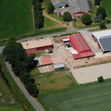
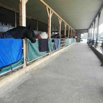
HIT Aktivstall
Brunsbüttel
Anki-Kuehl1
@Anki-Kuehl1
FN-Mitglied
Freizeitstall
Krankenbox
Longierzirkel/Roundpen
Notfallboxen
Pferdezucht
Bewegungsstall
Offenstall
16 weitere...
P
Leider kein Vorschaubild
Leider kein Vorschaubild
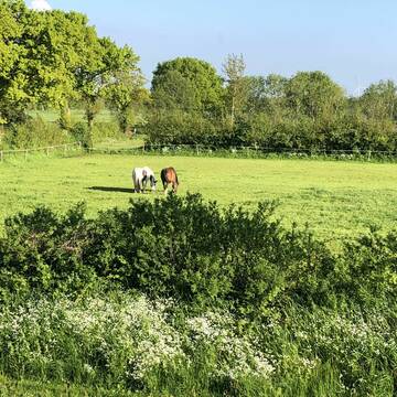
Boxen frei im Privatstall - viel draußen im Wint...
Brunsbüttel
Reiterhof Brunsbüttel
@Pferdehof_Brunsbuettel
Freizeitstall
Pflegepferd
Vermieten
Hunde willkommen
Krankenbox
Innenbox
Offenstall
10 weitere...
B
Deprecated: Creation of dynamic property Zend_View_Helper_Ads::$adLink is deprecated in /var/www/stall-frei/htdocs/staging.stall-frei.de/library/Psf/View/Helper/Ads.php on line 108

Das Beste für die Hufe
Mechtersen
STALL-FREIde Marketing
@STALL-FREI-Marketing
Hufschmiede und Hufpfleger in Ihrer Nähe
Reit- und Pensionsstall Mißfeldt
Tensbüttel-Röst
Andrea Mißfeldt
@Missfeldt250477
FN-Mitglied
Freizeitstall
Vermieten
Hunde willkommen
Krankenbox
Allergikerstall
bedampftes/gewaschenes Heu
33 weitere...
S
Leider kein Vorschaubild
Leider kein Vorschaubild
Box frei
Ramhusen
Claudia
@Claudia94
Freizeitstall
Vermieten
Longierzirkel/Roundpen
Paddock
Vollpension
7 weitere...
B
Leider kein Vorschaubild
Leider kein Vorschaubild
Offenstall - 2 Plätze frei, 220€
Landscheide
A. Kölln
@HofKoelln
Freizeitstall
Reitlehrer und -unterricht
Vermieten
Hunde willkommen
Krankenbox
Notfallboxen
6 weitere...
B

Gut Haneworth FN zertifizierte Pferdepension
Lamstedt
Gut-Haneworth
@Gut-Haneworth
FN-Mitglied
Freizeitstall
Longierzirkel/Roundpen
Paddock
bedampftes/gewaschenes Heu
Außenbox mit Paddock
Außenboxen
15 weitere...
P
Job gesucht?
Mechtersen
STALL-FREIde Marketing
@STALL-FREI-Marketing
Sie suchen einen Job und arbeiten gerne mit Pferden oder auf Reitanlagen?
Besuchen Sie jetzt unseren Stellenmarkt!

Offenstall Aufzucht Jungpferde & Rentner
Engelbrechtsche Wildnis
Landwirtschaft Strube GbR
@Stall-Strube
Krankenbox
Paddock
Fohlenaufzucht möglich
Hengsthaltung möglich
Offenstall
Vollpension
6 weitere...
P

Offenstall - Aufzucht - Kur - Tragende
Nordleda
Pferde_Norddeutschland
@Pferde_Norddeutschland
Vermieten
Hunde willkommen
Pensions- und Gastboxen
Allergikerstall
Hengsthaltung möglich
Bewegungsstall
Offenstall
7 weitere...
P
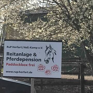
Reit- u. Pferdefreunde Herfart, u. U. e. V.
Heiligenstedtenerkamp
Reit- und Pferdefreunde e. V.
@RuPHerfartu.U.
FN-Mitglied
Freizeitstall
Vermieten
Hunde willkommen
Longierzirkel/Roundpen
Allergikerstall
18 weitere...
aktuell
P
Leider kein Vorschaubild
Leider kein Vorschaubild
Offenstallplatz für Wallach frei
Helse
Verena
@Verena123
Vermieten
Paddock
Reitplatz (z.B. Dressur, Springen, Reining)
Allergikerstall
Offenstall
3 weitere...
B
Deprecated: Creation of dynamic property Zend_View::$pageCount is deprecated in /var/www/stall-frei/htdocs/staging.stall-frei.de/library/vendor/shardj/zf1-future/library/Zend/View/Abstract.php on line 308
Deprecated: Creation of dynamic property Zend_View::$itemCountPerPage is deprecated in /var/www/stall-frei/htdocs/staging.stall-frei.de/library/vendor/shardj/zf1-future/library/Zend/View/Abstract.php on line 308
Deprecated: Creation of dynamic property Zend_View::$first is deprecated in /var/www/stall-frei/htdocs/staging.stall-frei.de/library/vendor/shardj/zf1-future/library/Zend/View/Abstract.php on line 308
Deprecated: Creation of dynamic property Zend_View::$current is deprecated in /var/www/stall-frei/htdocs/staging.stall-frei.de/library/vendor/shardj/zf1-future/library/Zend/View/Abstract.php on line 308
Deprecated: Creation of dynamic property Zend_View::$last is deprecated in /var/www/stall-frei/htdocs/staging.stall-frei.de/library/vendor/shardj/zf1-future/library/Zend/View/Abstract.php on line 308
Deprecated: Creation of dynamic property Zend_View::$next is deprecated in /var/www/stall-frei/htdocs/staging.stall-frei.de/library/vendor/shardj/zf1-future/library/Zend/View/Abstract.php on line 308
Deprecated: Creation of dynamic property Zend_View::$pagesInRange is deprecated in /var/www/stall-frei/htdocs/staging.stall-frei.de/library/vendor/shardj/zf1-future/library/Zend/View/Abstract.php on line 308
Deprecated: Creation of dynamic property Zend_View::$firstPageInRange is deprecated in /var/www/stall-frei/htdocs/staging.stall-frei.de/library/vendor/shardj/zf1-future/library/Zend/View/Abstract.php on line 308
Deprecated: Creation of dynamic property Zend_View::$lastPageInRange is deprecated in /var/www/stall-frei/htdocs/staging.stall-frei.de/library/vendor/shardj/zf1-future/library/Zend/View/Abstract.php on line 308
Deprecated: Creation of dynamic property Zend_View::$currentItemCount is deprecated in /var/www/stall-frei/htdocs/staging.stall-frei.de/library/vendor/shardj/zf1-future/library/Zend/View/Abstract.php on line 308
Deprecated: Creation of dynamic property Zend_View::$totalItemCount is deprecated in /var/www/stall-frei/htdocs/staging.stall-frei.de/library/vendor/shardj/zf1-future/library/Zend/View/Abstract.php on line 308
Deprecated: Creation of dynamic property Zend_View::$firstItemNumber is deprecated in /var/www/stall-frei/htdocs/staging.stall-frei.de/library/vendor/shardj/zf1-future/library/Zend/View/Abstract.php on line 308
Deprecated: Creation of dynamic property Zend_View::$lastItemNumber is deprecated in /var/www/stall-frei/htdocs/staging.stall-frei.de/library/vendor/shardj/zf1-future/library/Zend/View/Abstract.php on line 308
Deprecated: Creation of dynamic property Zend_View::$router is deprecated in /var/www/stall-frei/htdocs/staging.stall-frei.de/library/vendor/shardj/zf1-future/library/Zend/View/Abstract.php on line 308
Deprecated: Creation of dynamic property Zend_View::$urlParams is deprecated in /var/www/stall-frei/htdocs/staging.stall-frei.de/library/vendor/shardj/zf1-future/library/Zend/View/Abstract.php on line 308
Deprecated: Creation of dynamic property Zend_View::$showAds is deprecated in /var/www/stall-frei/htdocs/staging.stall-frei.de/library/vendor/shardj/zf1-future/library/Zend/View/Abstract.php on line 308
Deprecated: Creation of dynamic property Zend_View::$objectIds is deprecated in /var/www/stall-frei/htdocs/staging.stall-frei.de/library/vendor/shardj/zf1-future/library/Zend/View/Abstract.php on line 308
Deprecated: Creation of dynamic property Zend_View::$showNavbar is deprecated in /var/www/stall-frei/htdocs/staging.stall-frei.de/library/vendor/shardj/zf1-future/library/Zend/View/Abstract.php on line 308
Deprecated: Creation of dynamic property Zend_View::$showBreadcrumb is deprecated in /var/www/stall-frei/htdocs/staging.stall-frei.de/library/vendor/shardj/zf1-future/library/Zend/View/Abstract.php on line 308
Deprecated: Creation of dynamic property Zend_View::$showFooter is deprecated in /var/www/stall-frei/htdocs/staging.stall-frei.de/library/vendor/shardj/zf1-future/library/Zend/View/Abstract.php on line 308
Deprecated: Creation of dynamic property Zend_View::$showInternalAds is deprecated in /var/www/stall-frei/htdocs/staging.stall-frei.de/library/vendor/shardj/zf1-future/library/Zend/View/Abstract.php on line 308
Deprecated: Creation of dynamic property Zend_View::$blNoContent is deprecated in /var/www/stall-frei/htdocs/staging.stall-frei.de/library/vendor/shardj/zf1-future/library/Zend/View/Abstract.php on line 308
Deprecated: Creation of dynamic property Zend_View::$sMetaDesc is deprecated in /var/www/stall-frei/htdocs/staging.stall-frei.de/library/vendor/shardj/zf1-future/library/Zend/View/Abstract.php on line 308
Deprecated: Creation of dynamic property Zend_View::$useGmaps is deprecated in /var/www/stall-frei/htdocs/staging.stall-frei.de/library/vendor/shardj/zf1-future/library/Zend/View/Abstract.php on line 308
Deprecated: Creation of dynamic property Zend_View::$touches is deprecated in /var/www/stall-frei/htdocs/staging.stall-frei.de/library/vendor/shardj/zf1-future/library/Zend/View/Abstract.php on line 308
Deprecated: Creation of dynamic property Zend_View::$oProject is deprecated in /var/www/stall-frei/htdocs/staging.stall-frei.de/library/vendor/shardj/zf1-future/library/Zend/View/Abstract.php on line 308
Deprecated: Creation of dynamic property Zend_View::$pageHeadline is deprecated in /var/www/stall-frei/htdocs/staging.stall-frei.de/library/vendor/shardj/zf1-future/library/Zend/View/Abstract.php on line 308
Deprecated: Creation of dynamic property Zend_View::$disableLocationField is deprecated in /var/www/stall-frei/htdocs/staging.stall-frei.de/library/vendor/shardj/zf1-future/library/Zend/View/Abstract.php on line 308
Deprecated: Creation of dynamic property Zend_View::$isSearch is deprecated in /var/www/stall-frei/htdocs/staging.stall-frei.de/library/vendor/shardj/zf1-future/library/Zend/View/Abstract.php on line 308
Deprecated: Creation of dynamic property Zend_View::$pageTitle is deprecated in /var/www/stall-frei/htdocs/staging.stall-frei.de/library/vendor/shardj/zf1-future/library/Zend/View/Abstract.php on line 308
Deprecated: Creation of dynamic property Psf_Form_Element_Text::$class is deprecated in /var/www/stall-frei/htdocs/staging.stall-frei.de/library/vendor/shardj/zf1-future/library/Zend/Form/Element.php on line 874
Deprecated: Creation of dynamic property Psf_Form_Element_Text::$size is deprecated in /var/www/stall-frei/htdocs/staging.stall-frei.de/library/vendor/shardj/zf1-future/library/Zend/Form/Element.php on line 874
Deprecated: Creation of dynamic property Psf_Form_Element_Text::$placeholder is deprecated in /var/www/stall-frei/htdocs/staging.stall-frei.de/library/vendor/shardj/zf1-future/library/Zend/Form/Element.php on line 874
Deprecated: Creation of dynamic property Psf_Form_Element_Hidden::$class is deprecated in /var/www/stall-frei/htdocs/staging.stall-frei.de/library/vendor/shardj/zf1-future/library/Zend/Form/Element.php on line 874
Deprecated: Creation of dynamic property Psf_Form_Element_Hidden::$class is deprecated in /var/www/stall-frei/htdocs/staging.stall-frei.de/library/vendor/shardj/zf1-future/library/Zend/Form/Element.php on line 874
Deprecated: Creation of dynamic property Psf_Form_Element_Hidden::$class is deprecated in /var/www/stall-frei/htdocs/staging.stall-frei.de/library/vendor/shardj/zf1-future/library/Zend/Form/Element.php on line 874
Deprecated: Creation of dynamic property Psf_Form_Element_Hidden::$class is deprecated in /var/www/stall-frei/htdocs/staging.stall-frei.de/library/vendor/shardj/zf1-future/library/Zend/Form/Element.php on line 874
Deprecated: Creation of dynamic property Psf_Form_Element_Select::$class is deprecated in /var/www/stall-frei/htdocs/staging.stall-frei.de/library/vendor/shardj/zf1-future/library/Zend/Form/Element.php on line 874
Deprecated: Creation of dynamic property Psf_Form_Element_Select::$class is deprecated in /var/www/stall-frei/htdocs/staging.stall-frei.de/library/vendor/shardj/zf1-future/library/Zend/Form/Element.php on line 874
Deprecated: Creation of dynamic property Psf_Form_Element_Select::$class is deprecated in /var/www/stall-frei/htdocs/staging.stall-frei.de/library/vendor/shardj/zf1-future/library/Zend/Form/Element.php on line 874
Deprecated: Creation of dynamic property Psf_Form_Element_Select::$class is deprecated in /var/www/stall-frei/htdocs/staging.stall-frei.de/library/vendor/shardj/zf1-future/library/Zend/Form/Element.php on line 874
Deprecated: Creation of dynamic property Psf_Form_Element_Text::$class is deprecated in /var/www/stall-frei/htdocs/staging.stall-frei.de/library/vendor/shardj/zf1-future/library/Zend/Form/Element.php on line 874
Deprecated: Creation of dynamic property Psf_Form_Element_Checkbox::$label is deprecated in /var/www/stall-frei/htdocs/staging.stall-frei.de/library/vendor/shardj/zf1-future/library/Zend/Form/Element.php on line 874
Deprecated: Creation of dynamic property Zend_View::$sort is deprecated in /var/www/stall-frei/htdocs/staging.stall-frei.de/library/vendor/shardj/zf1-future/library/Zend/View/Abstract.php on line 308
Deprecated: Creation of dynamic property Zend_View::$searchLocation is deprecated in /var/www/stall-frei/htdocs/staging.stall-frei.de/library/vendor/shardj/zf1-future/library/Zend/View/Abstract.php on line 308
Deprecated: Creation of dynamic property Zend_View::$locationHint is deprecated in /var/www/stall-frei/htdocs/staging.stall-frei.de/library/vendor/shardj/zf1-future/library/Zend/View/Abstract.php on line 308
Psf_GeoCoder_Abstract::getLocation: Balje Get Location CachedOrLive
Psf_GeoCoder_Abstract::getCachedOrLive: Balje
Psf_GeoCoder_OpenCageData::makeApiRequest: response:
Array
(
[documentation] => https://opencagedata.com/api
[licenses] => Array
(
[0] => Array
(
[name] => see attribution guide
[url] => https://opencagedata.com/credits
)
)
[results] => Array
(
[0] => Array
(
[bounds] => Array
(
[northeast] => Array
(
[lat] => 53.864651
[lng] => 9.1917846
)
[southwest] => Array
(
[lat] => 53.7905977
[lng] => 9.0132319
)
)
[components] => Array
(
[ISO_3166-1_alpha-2] => DE
[ISO_3166-1_alpha-3] => DEU
[ISO_3166-2] => Array
(
[0] => DE-NI
)
[_category] => place
[_normalized_city] => Balje
[_type] => village
[continent] => Europe
[country] => Deutschland
[country_code] => de
[county] => Landkreis Stade
[municipality] => Samtgemeinde Nordkehdingen
[political_union] => European Union
[postcode] => 21730
[state] => Niedersachsen
[state_code] => NI
[village] => Balje
)
[confidence] => 6
[formatted] => 21730 Balje, Deutschland
[geometry] => Array
(
[lat] => 53.8333
[lng] => 9.13333
)
)
[1] => Array
(
[bounds] => Array
(
[northeast] => Array
(
[lat] => 53.3387821
[lng] => 8.520283
)
[southwest] => Array
(
[lat] => 53.3367584
[lng] => 8.51953
)
)
[components] => Array
(
[ISO_3166-1_alpha-2] => DE
[ISO_3166-1_alpha-3] => DEU
[ISO_3166-2] => Array
(
[0] => DE-NI
)
[_category] => unknown
[_normalized_city] => Hagen im Bremischen
[_type] => ditch
[continent] => Europe
[country] => Deutschland
[country_code] => de
[county] => Landkreis Cuxhaven
[ditch] => Balje
[political_union] => European Union
[postcode] => 27628
[state] => Niedersachsen
[state_code] => NI
[town] => Hagen im Bremischen
[village] => Sandstedt
)
[confidence] => 9
[formatted] => Balje, 27628 Sandstedt, Deutschland
[geometry] => Array
(
[lat] => 53.3376553
[lng] => 8.5199309
)
)
[2] => Array
(
[components] => Array
(
[ISO_3166-1_alpha-2] => FR
[ISO_3166-1_alpha-3] => FRA
[ISO_3166-2] => Array
(
[0] => FR-IDF
[1] => FR-92
)
[_category] => road
[_normalized_city] => Levallois-Perret
[_type] => road
[city] => Levallois-Perret
[continent] => Europe
[country] => France
[country_code] => fr
[county] => Hauts-de-Seine
[local_authority] => Métropole du Grand Paris
[political_union] => European Union
[postcode] => 92300
[road] => Rue Charles Deutschmann
[state] => Île-de-France
[state_code] => IDF
)
[confidence] => 3
[formatted] => Rue Charles Deutschmann, 92300 Levallois-Perret, France
[geometry] => Array
(
[lat] => 48.900049
[lng] => 2.2842
)
)
[3] => Array
(
[components] => Array
(
[ISO_3166-1_alpha-2] => FR
[ISO_3166-1_alpha-3] => FRA
[ISO_3166-2] => Array
(
[0] => FR-OCC
[1] => FR-82
)
[_category] => road
[_normalized_city] => Montauban
[_type] => road
[city] => Montauban
[continent] => Europe
[country] => France
[country_code] => fr
[county] => Tarn-et-Garonne
[local_authority] => Grand Montauban
[political_union] => European Union
[postcode] => 82000
[road] => chemin de balat
[state] => Occitanie
[state_code] => OCC
)
[confidence] => 3
[formatted] => chemin de balat, 82000 Montauban, France
[geometry] => Array
(
[lat] => 44.055361
[lng] => 1.406601
)
)
[4] => Array
(
[components] => Array
(
[ISO_3166-1_alpha-2] => FR
[ISO_3166-1_alpha-3] => FRA
[ISO_3166-2] => Array
(
[0] => FR-OCC
[1] => FR-31
)
[_category] => road
[_normalized_city] => Carbonne
[_type] => road
[city] => Carbonne
[continent] => Europe
[country] => France
[country_code] => fr
[county] => Haute-Garonne
[local_authority] => Communauté de communes du Volvestre
[political_union] => European Union
[postcode] => 31390
[road] => chemin de Balas
[state] => Occitanie
[state_code] => OCC
)
[confidence] => 3
[formatted] => chemin de Balas, 31390 Carbonne, France
[geometry] => Array
(
[lat] => 43.300362
[lng] => 1.205188
)
)
[5] => Array
(
[components] => Array
(
[ISO_3166-1_alpha-2] => FR
[ISO_3166-1_alpha-3] => FRA
[ISO_3166-2] => Array
(
[0] => FR-OCC
[1] => FR-32
)
[_category] => road
[_normalized_city] => Viella
[_type] => road
[city] => Viella
[continent] => Europe
[country] => France
[country_code] => fr
[county] => Gers
[local_authority] => Communauté de communes Armagnac Adour
[political_union] => European Union
[postcode] => 32400
[road] => chemin de bala
[state] => Occitanie
[state_code] => OCC
)
[confidence] => 3
[formatted] => chemin de bala, 32400 Viella, France
[geometry] => Array
(
[lat] => 43.601233
[lng] => -0.128319
)
)
[6] => Array
(
[components] => Array
(
[ISO_3166-1_alpha-2] => FR
[ISO_3166-1_alpha-3] => FRA
[ISO_3166-2] => Array
(
[0] => FR-ARA
[1] => FR-63
)
[_category] => road
[_normalized_city] => Murol
[_type] => road
[city] => Murol
[continent] => Europe
[country] => France
[country_code] => fr
[county] => Puy-de-Dôme
[local_authority] => Communauté de communes du Massif du Sancy
[political_union] => European Union
[postcode] => 63790
[road] => Rue des ballats
[state] => Auvergne-Rhône-Alpes
[state_code] => ARA
)
[confidence] => 3
[formatted] => Rue des ballats, 63790 Murol, France
[geometry] => Array
(
[lat] => 45.574262
[lng] => 2.94975
)
)
[7] => Array
(
[components] => Array
(
[ISO_3166-1_alpha-2] => FR
[ISO_3166-1_alpha-3] => FRA
[ISO_3166-2] => Array
(
[0] => FR-ARA
[1] => FR-15
)
[_category] => road
[_normalized_city] => Lorcières
[_type] => road
[city] => Lorcières
[continent] => Europe
[country] => France
[country_code] => fr
[county] => Cantal
[local_authority] => Saint-Flour Communauté
[political_union] => European Union
[postcode] => 15320
[road] => rue des Balats
[state] => Auvergne-Rhône-Alpes
[state_code] => ARA
)
[confidence] => 3
[formatted] => rue des Balats, 15320 Lorcières, France
[geometry] => Array
(
[lat] => 44.959296
[lng] => 3.309386
)
)
[8] => Array
(
[components] => Array
(
[ISO_3166-1_alpha-2] => FR
[ISO_3166-1_alpha-3] => FRA
[ISO_3166-2] => Array
(
[0] => FR-NOR
[1] => FR-61
)
[_category] => road
[_normalized_city] => Saint-Aquilin-de-Corbion
[_type] => road
[city] => Saint-Aquilin-de-Corbion
[continent] => Europe
[country] => France
[country_code] => fr
[county] => Orne
[local_authority] => Communauté de communes du Pays de Mortagne au Perche
[political_union] => European Union
[postcode] => 61380
[road] => Chemin de Bala
[state] => Normandie
[state_code] => NOR
)
[confidence] => 3
[formatted] => Chemin de Bala, 61380 Saint-Aquilin-de-Corbion, France
[geometry] => Array
(
[lat] => 48.635473
[lng] => 0.527783
)
)
[9] => Array
(
[components] => Array
(
[ISO_3166-1_alpha-2] => FR
[ISO_3166-1_alpha-3] => FRA
[ISO_3166-2] => Array
(
[0] => FR-OCC
[1] => FR-46
)
[_category] => road
[_normalized_city] => Cénevières
[_type] => road
[city] => Cénevières
[continent] => Europe
[country] => France
[country_code] => fr
[county] => Lot
[local_authority] => Communauté de communes du Pays de Lalbenque-Limogne
[political_union] => European Union
[postcode] => 46330
[road] => Chemin de Balat
[state] => Occitanie
[state_code] => OCC
)
[confidence] => 3
[formatted] => Chemin de Balat, 46330 Cénevières, France
[geometry] => Array
(
[lat] => 44.430758
[lng] => 1.745818
)
)
)
[status] => Array
(
[code] => 200
[message] => OK
)
[stay_informed] => Array
(
[blog] => https://blog.opencagedata.com
[mastodon] => https://en.osm.town/@opencage
)
[thanks] => For using an OpenCage API
[timestamp] => Array
(
[created_http] => Sat, 07 Feb 2026 11:37:54 GMT
[created_unix] => 1770464274
)
[total_results] => 10
)
Psf_GeoCoder_Abstract::convertLocationResult
{"documentation":"https:\/\/opencagedata.com\/api","licenses":[{"name":"see attribution guide","url":"https:\/\/opencagedata.com\/credits"}],"results":[{"bounds":{"northeast":{"lat":53.864651,"lng":9.1917846},"southwest":{"lat":53.7905977,"lng":9.0132319}},"components":{"ISO_3166-1_alpha-2":"DE","ISO_3166-1_alpha-3":"DEU","ISO_3166-2":["DE-NI"],"_category":"place","_normalized_city":"Balje","_type":"village","continent":"Europe","country":"Deutschland","country_code":"de","county":"Landkreis Stade","municipality":"Samtgemeinde Nordkehdingen","political_union":"European Union","postcode":"21730","state":"Niedersachsen","state_code":"NI","village":"Balje"},"confidence":6,"formatted":"21730 Balje, Deutschland","geometry":{"lat":53.8333,"lng":9.13333}},{"bounds":{"northeast":{"lat":53.3387821,"lng":8.520283},"southwest":{"lat":53.3367584,"lng":8.51953}},"components":{"ISO_3166-1_alpha-2":"DE","ISO_3166-1_alpha-3":"DEU","ISO_3166-2":["DE-NI"],"_category":"unknown","_normalized_city":"Hagen im Bremischen","_type":"ditch","continent":"Europe","country":"Deutschland","country_code":"de","county":"Landkreis Cuxhaven","ditch":"Balje","political_union":"European Union","postcode":"27628","state":"Niedersachsen","state_code":"NI","town":"Hagen im Bremischen","village":"Sandstedt"},"confidence":9,"formatted":"Balje, 27628 Sandstedt, Deutschland","geometry":{"lat":53.3376553,"lng":8.5199309}},{"components":{"ISO_3166-1_alpha-2":"FR","ISO_3166-1_alpha-3":"FRA","ISO_3166-2":["FR-IDF","FR-92"],"_category":"road","_normalized_city":"Levallois-Perret","_type":"road","city":"Levallois-Perret","continent":"Europe","country":"France","country_code":"fr","county":"Hauts-de-Seine","local_authority":"M\u00e9tropole du Grand Paris","political_union":"European Union","postcode":"92300","road":"Rue Charles Deutschmann","state":"\u00cele-de-France","state_code":"IDF"},"confidence":3,"formatted":"Rue Charles Deutschmann, 92300 Levallois-Perret, France","geometry":{"lat":48.900049,"lng":2.2842}},{"components":{"ISO_3166-1_alpha-2":"FR","ISO_3166-1_alpha-3":"FRA","ISO_3166-2":["FR-OCC","FR-82"],"_category":"road","_normalized_city":"Montauban","_type":"road","city":"Montauban","continent":"Europe","country":"France","country_code":"fr","county":"Tarn-et-Garonne","local_authority":"Grand Montauban","political_union":"European Union","postcode":"82000","road":"chemin de balat","state":"Occitanie","state_code":"OCC"},"confidence":3,"formatted":"chemin de balat, 82000 Montauban, France","geometry":{"lat":44.055361,"lng":1.406601}},{"components":{"ISO_3166-1_alpha-2":"FR","ISO_3166-1_alpha-3":"FRA","ISO_3166-2":["FR-OCC","FR-31"],"_category":"road","_normalized_city":"Carbonne","_type":"road","city":"Carbonne","continent":"Europe","country":"France","country_code":"fr","county":"Haute-Garonne","local_authority":"Communaut\u00e9 de communes du Volvestre","political_union":"European Union","postcode":"31390","road":"chemin de Balas","state":"Occitanie","state_code":"OCC"},"confidence":3,"formatted":"chemin de Balas, 31390 Carbonne, France","geometry":{"lat":43.300362,"lng":1.205188}},{"components":{"ISO_3166-1_alpha-2":"FR","ISO_3166-1_alpha-3":"FRA","ISO_3166-2":["FR-OCC","FR-32"],"_category":"road","_normalized_city":"Viella","_type":"road","city":"Viella","continent":"Europe","country":"France","country_code":"fr","county":"Gers","local_authority":"Communaut\u00e9 de communes Armagnac Adour","political_union":"European Union","postcode":"32400","road":"chemin de bala","state":"Occitanie","state_code":"OCC"},"confidence":3,"formatted":"chemin de bala, 32400 Viella, France","geometry":{"lat":43.601233,"lng":-0.128319}},{"components":{"ISO_3166-1_alpha-2":"FR","ISO_3166-1_alpha-3":"FRA","ISO_3166-2":["FR-ARA","FR-63"],"_category":"road","_normalized_city":"Murol","_type":"road","city":"Murol","continent":"Europe","country":"France","country_code":"fr","county":"Puy-de-D\u00f4me","local_authority":"Communaut\u00e9 de communes du Massif du Sancy","political_union":"European Union","postcode":"63790","road":"Rue des ballats","state":"Auvergne-Rh\u00f4ne-Alpes","state_code":"ARA"},"confidence":3,"formatted":"Rue des ballats, 63790 Murol, France","geometry":{"lat":45.574262,"lng":2.94975}},{"components":{"ISO_3166-1_alpha-2":"FR","ISO_3166-1_alpha-3":"FRA","ISO_3166-2":["FR-ARA","FR-15"],"_category":"road","_normalized_city":"Lorci\u00e8res","_type":"road","city":"Lorci\u00e8res","continent":"Europe","country":"France","country_code":"fr","county":"Cantal","local_authority":"Saint-Flour Communaut\u00e9","political_union":"European Union","postcode":"15320","road":"rue des Balats","state":"Auvergne-Rh\u00f4ne-Alpes","state_code":"ARA"},"confidence":3,"formatted":"rue des Balats, 15320 Lorci\u00e8res, France","geometry":{"lat":44.959296,"lng":3.309386}},{"components":{"ISO_3166-1_alpha-2":"FR","ISO_3166-1_alpha-3":"FRA","ISO_3166-2":["FR-NOR","FR-61"],"_category":"road","_normalized_city":"Saint-Aquilin-de-Corbion","_type":"road","city":"Saint-Aquilin-de-Corbion","continent":"Europe","country":"France","country_code":"fr","county":"Orne","local_authority":"Communaut\u00e9 de communes du Pays de Mortagne au Perche","political_union":"European Union","postcode":"61380","road":"Chemin de Bala","state":"Normandie","state_code":"NOR"},"confidence":3,"formatted":"Chemin de Bala, 61380 Saint-Aquilin-de-Corbion, France","geometry":{"lat":48.635473,"lng":0.527783}},{"components":{"ISO_3166-1_alpha-2":"FR","ISO_3166-1_alpha-3":"FRA","ISO_3166-2":["FR-OCC","FR-46"],"_category":"road","_normalized_city":"C\u00e9nevi\u00e8res","_type":"road","city":"C\u00e9nevi\u00e8res","continent":"Europe","country":"France","country_code":"fr","county":"Lot","local_authority":"Communaut\u00e9 de communes du Pays de Lalbenque-Limogne","political_union":"European Union","postcode":"46330","road":"Chemin de Balat","state":"Occitanie","state_code":"OCC"},"confidence":3,"formatted":"Chemin de Balat, 46330 C\u00e9nevi\u00e8res, France","geometry":{"lat":44.430758,"lng":1.745818}}],"status":{"code":200,"message":"OK"},"stay_informed":{"blog":"https:\/\/blog.opencagedata.com","mastodon":"https:\/\/en.osm.town\/@opencage"},"thanks":"For using an OpenCage API","timestamp":{"created_http":"Sat, 07 Feb 2026 11:37:54 GMT","created_unix":1770464274},"total_results":10}Array
(
[0] => stdClass Object
(
[bounds] => stdClass Object
(
[northeast] => stdClass Object
(
[lat] => 53.864651
[lng] => 9.1917846
)
[southwest] => stdClass Object
(
[lat] => 53.7905977
[lng] => 9.0132319
)
)
[components] => stdClass Object
(
[ISO_3166-1_alpha-2] => DE
[ISO_3166-1_alpha-3] => DEU
[ISO_3166-2] => Array
(
[0] => DE-NI
)
[_category] => place
[_normalized_city] => Balje
[_type] => village
[continent] => Europe
[country] => Deutschland
[country_code] => de
[county] => Landkreis Stade
[municipality] => Samtgemeinde Nordkehdingen
[political_union] => European Union
[postcode] => 21730
[state] => Niedersachsen
[state_code] => NI
[village] => Balje
)
[confidence] => 6
[formatted] => 21730 Balje, Deutschland
[geometry] => stdClass Object
(
[lat] => 53.8333
[lng] => 9.13333
)
)
[1] => stdClass Object
(
[bounds] => stdClass Object
(
[northeast] => stdClass Object
(
[lat] => 53.3387821
[lng] => 8.520283
)
[southwest] => stdClass Object
(
[lat] => 53.3367584
[lng] => 8.51953
)
)
[components] => stdClass Object
(
[ISO_3166-1_alpha-2] => DE
[ISO_3166-1_alpha-3] => DEU
[ISO_3166-2] => Array
(
[0] => DE-NI
)
[_category] => unknown
[_normalized_city] => Hagen im Bremischen
[_type] => ditch
[continent] => Europe
[country] => Deutschland
[country_code] => de
[county] => Landkreis Cuxhaven
[ditch] => Balje
[political_union] => European Union
[postcode] => 27628
[state] => Niedersachsen
[state_code] => NI
[town] => Hagen im Bremischen
[village] => Sandstedt
)
[confidence] => 9
[formatted] => Balje, 27628 Sandstedt, Deutschland
[geometry] => stdClass Object
(
[lat] => 53.3376553
[lng] => 8.5199309
)
)
[2] => stdClass Object
(
[components] => stdClass Object
(
[ISO_3166-1_alpha-2] => FR
[ISO_3166-1_alpha-3] => FRA
[ISO_3166-2] => Array
(
[0] => FR-IDF
[1] => FR-92
)
[_category] => road
[_normalized_city] => Levallois-Perret
[_type] => road
[city] => Levallois-Perret
[continent] => Europe
[country] => France
[country_code] => fr
[county] => Hauts-de-Seine
[local_authority] => Métropole du Grand Paris
[political_union] => European Union
[postcode] => 92300
[road] => Rue Charles Deutschmann
[state] => Île-de-France
[state_code] => IDF
)
[confidence] => 3
[formatted] => Rue Charles Deutschmann, 92300 Levallois-Perret, France
[geometry] => stdClass Object
(
[lat] => 48.900049
[lng] => 2.2842
)
)
[3] => stdClass Object
(
[components] => stdClass Object
(
[ISO_3166-1_alpha-2] => FR
[ISO_3166-1_alpha-3] => FRA
[ISO_3166-2] => Array
(
[0] => FR-OCC
[1] => FR-82
)
[_category] => road
[_normalized_city] => Montauban
[_type] => road
[city] => Montauban
[continent] => Europe
[country] => France
[country_code] => fr
[county] => Tarn-et-Garonne
[local_authority] => Grand Montauban
[political_union] => European Union
[postcode] => 82000
[road] => chemin de balat
[state] => Occitanie
[state_code] => OCC
)
[confidence] => 3
[formatted] => chemin de balat, 82000 Montauban, France
[geometry] => stdClass Object
(
[lat] => 44.055361
[lng] => 1.406601
)
)
[4] => stdClass Object
(
[components] => stdClass Object
(
[ISO_3166-1_alpha-2] => FR
[ISO_3166-1_alpha-3] => FRA
[ISO_3166-2] => Array
(
[0] => FR-OCC
[1] => FR-31
)
[_category] => road
[_normalized_city] => Carbonne
[_type] => road
[city] => Carbonne
[continent] => Europe
[country] => France
[country_code] => fr
[county] => Haute-Garonne
[local_authority] => Communauté de communes du Volvestre
[political_union] => European Union
[postcode] => 31390
[road] => chemin de Balas
[state] => Occitanie
[state_code] => OCC
)
[confidence] => 3
[formatted] => chemin de Balas, 31390 Carbonne, France
[geometry] => stdClass Object
(
[lat] => 43.300362
[lng] => 1.205188
)
)
[5] => stdClass Object
(
[components] => stdClass Object
(
[ISO_3166-1_alpha-2] => FR
[ISO_3166-1_alpha-3] => FRA
[ISO_3166-2] => Array
(
[0] => FR-OCC
[1] => FR-32
)
[_category] => road
[_normalized_city] => Viella
[_type] => road
[city] => Viella
[continent] => Europe
[country] => France
[country_code] => fr
[county] => Gers
[local_authority] => Communauté de communes Armagnac Adour
[political_union] => European Union
[postcode] => 32400
[road] => chemin de bala
[state] => Occitanie
[state_code] => OCC
)
[confidence] => 3
[formatted] => chemin de bala, 32400 Viella, France
[geometry] => stdClass Object
(
[lat] => 43.601233
[lng] => -0.128319
)
)
[6] => stdClass Object
(
[components] => stdClass Object
(
[ISO_3166-1_alpha-2] => FR
[ISO_3166-1_alpha-3] => FRA
[ISO_3166-2] => Array
(
[0] => FR-ARA
[1] => FR-63
)
[_category] => road
[_normalized_city] => Murol
[_type] => road
[city] => Murol
[continent] => Europe
[country] => France
[country_code] => fr
[county] => Puy-de-Dôme
[local_authority] => Communauté de communes du Massif du Sancy
[political_union] => European Union
[postcode] => 63790
[road] => Rue des ballats
[state] => Auvergne-Rhône-Alpes
[state_code] => ARA
)
[confidence] => 3
[formatted] => Rue des ballats, 63790 Murol, France
[geometry] => stdClass Object
(
[lat] => 45.574262
[lng] => 2.94975
)
)
[7] => stdClass Object
(
[components] => stdClass Object
(
[ISO_3166-1_alpha-2] => FR
[ISO_3166-1_alpha-3] => FRA
[ISO_3166-2] => Array
(
[0] => FR-ARA
[1] => FR-15
)
[_category] => road
[_normalized_city] => Lorcières
[_type] => road
[city] => Lorcières
[continent] => Europe
[country] => France
[country_code] => fr
[county] => Cantal
[local_authority] => Saint-Flour Communauté
[political_union] => European Union
[postcode] => 15320
[road] => rue des Balats
[state] => Auvergne-Rhône-Alpes
[state_code] => ARA
)
[confidence] => 3
[formatted] => rue des Balats, 15320 Lorcières, France
[geometry] => stdClass Object
(
[lat] => 44.959296
[lng] => 3.309386
)
)
[8] => stdClass Object
(
[components] => stdClass Object
(
[ISO_3166-1_alpha-2] => FR
[ISO_3166-1_alpha-3] => FRA
[ISO_3166-2] => Array
(
[0] => FR-NOR
[1] => FR-61
)
[_category] => road
[_normalized_city] => Saint-Aquilin-de-Corbion
[_type] => road
[city] => Saint-Aquilin-de-Corbion
[continent] => Europe
[country] => France
[country_code] => fr
[county] => Orne
[local_authority] => Communauté de communes du Pays de Mortagne au Perche
[political_union] => European Union
[postcode] => 61380
[road] => Chemin de Bala
[state] => Normandie
[state_code] => NOR
)
[confidence] => 3
[formatted] => Chemin de Bala, 61380 Saint-Aquilin-de-Corbion, France
[geometry] => stdClass Object
(
[lat] => 48.635473
[lng] => 0.527783
)
)
[9] => stdClass Object
(
[components] => stdClass Object
(
[ISO_3166-1_alpha-2] => FR
[ISO_3166-1_alpha-3] => FRA
[ISO_3166-2] => Array
(
[0] => FR-OCC
[1] => FR-46
)
[_category] => road
[_normalized_city] => Cénevières
[_type] => road
[city] => Cénevières
[continent] => Europe
[country] => France
[country_code] => fr
[county] => Lot
[local_authority] => Communauté de communes du Pays de Lalbenque-Limogne
[political_union] => European Union
[postcode] => 46330
[road] => Chemin de Balat
[state] => Occitanie
[state_code] => OCC
)
[confidence] => 3
[formatted] => Chemin de Balat, 46330 Cénevières, France
[geometry] => stdClass Object
(
[lat] => 44.430758
[lng] => 1.745818
)
)
)
Psf_GeoCoder_OpenCageData::getKeyMap: 0
stdClass Object
(
    [bounds] => stdClass Object
        (
            [northeast] => stdClass Object
                (
                    [lat] => 53.864651
                    [lng] => 9.1917846
                )

            [southwest] => stdClass Object
                (
                    [lat] => 53.7905977
                    [lng] => 9.0132319
                )

        )

    [components] => stdClass Object
        (
            [ISO_3166-1_alpha-2] => DE
            [ISO_3166-1_alpha-3] => DEU
            [ISO_3166-2] => Array
                (
                    [0] => DE-NI
                )

            [_category] => place
            [_normalized_city] => Balje
            [_type] => village
            [continent] => Europe
            [country] => Deutschland
            [country_code] => de
            [county] => Landkreis Stade
            [municipality] => Samtgemeinde Nordkehdingen
            [political_union] => European Union
            [postcode] => 21730
            [state] => Niedersachsen
            [state_code] => NI
            [village] => Balje
        )

    [confidence] => 6
    [formatted] => 21730 Balje, Deutschland
    [geometry] => stdClass Object
        (
            [lat] => 53.8333
            [lng] => 9.13333
        )

)
Psf_GeoCoder_OpenCageData::getCounty: Stade
Psf_GeoCoder_OpenCageData::addMissingData REFETCH!
Array
(
    [address] => 21730 Balje, Deutschland
    [type] => village
    [street] =>
    [city] => Balje
    [county] => Stade
    [state] => Niedersachsen
    [zip] => 21730
    [country] => Deutschland
    [suburb] =>
    [countrycode] => de
    [latitude] => 53.8333
    [longitude] => 9.13333
    [accuracy] => 1
    [confidence] => 6
    [bounds] => stdClass Object
        (
            [northeast] => stdClass Object
                (
                    [lat] => 53.864651
                    [lng] => 9.1917846
                )

            [southwest] => stdClass Object
                (
                    [lat] => 53.7905977
                    [lng] => 9.0132319
                )

        )

)
reformat!
Array
(
    [address] => 21730 Balje, Deutschland
    [type] => village
    [street] =>
    [city] => Balje
    [county] => Stade
    [state] => Niedersachsen
    [zip] => 21730
    [country] => Deutschland
    [suburb] =>
    [countrycode] => de
    [latitude] => 53.8333
    [longitude] => 9.13333
    [accuracy] => 1
    [confidence] => 6
    [bounds] => stdClass Object
        (
            [northeast] => stdClass Object
                (
                    [lat] => 53.864651
                    [lng] => 9.1917846
                )

            [southwest] => stdClass Object
                (
                    [lat] => 53.7905977
                    [lng] => 9.0132319
                )

        )

    [place] => 21730 Balje, Niedersachsen
    [hash] => 71bacd2d4401df08248a33c445ad117c
)
Psf_GeoCoder_OpenCageData::getKeyMap: 1
stdClass Object
(
    [bounds] => stdClass Object
        (
            [northeast] => stdClass Object
                (
                    [lat] => 53.3387821
                    [lng] => 8.520283
                )

            [southwest] => stdClass Object
                (
                    [lat] => 53.3367584
                    [lng] => 8.51953
                )

        )

    [components] => stdClass Object
        (
            [ISO_3166-1_alpha-2] => DE
            [ISO_3166-1_alpha-3] => DEU
            [ISO_3166-2] => Array
                (
                    [0] => DE-NI
                )

            [_category] => unknown
            [_normalized_city] => Hagen im Bremischen
            [_type] => ditch
            [continent] => Europe
            [country] => Deutschland
            [country_code] => de
            [county] => Landkreis Cuxhaven
            [ditch] => Balje
            [political_union] => European Union
            [postcode] => 27628
            [state] => Niedersachsen
            [state_code] => NI
            [town] => Hagen im Bremischen
            [village] => Sandstedt
        )

    [confidence] => 9
    [formatted] => Balje, 27628 Sandstedt, Deutschland
    [geometry] => stdClass Object
        (
            [lat] => 53.3376553
            [lng] => 8.5199309
        )

)
Psf_GeoCoder_OpenCageData::getCounty: Cuxhaven
Psf_GeoCoder_OpenCageData::addMissingData REFETCH!
Array
(
    [address] => Balje, 27628 Sandstedt, Deutschland
    [type] => ditch
    [street] =>
    [city] => Hagen im Bremischen
    [county] => Cuxhaven
    [state] => Niedersachsen
    [zip] => 27628
    [country] => Deutschland
    [suburb] =>
    [countrycode] => de
    [latitude] => 53.3376553
    [longitude] => 8.5199309
    [accuracy] => 1
    [confidence] => 9
    [bounds] => stdClass Object
        (
            [northeast] => stdClass Object
                (
                    [lat] => 53.3387821
                    [lng] => 8.520283
                )

            [southwest] => stdClass Object
                (
                    [lat] => 53.3367584
                    [lng] => 8.51953
                )

        )

)
reformat!
Array
(
    [address] => 27628 Hagen im Bremischen
    [type] => ditch
    [street] =>
    [city] => Hagen im Bremischen
    [county] => Cuxhaven
    [state] => Niedersachsen
    [zip] => 27628
    [country] => Deutschland
    [suburb] =>
    [countrycode] => de
    [latitude] => 53.3376553
    [longitude] => 8.5199309
    [accuracy] => 1
    [confidence] => 9
    [bounds] => stdClass Object
        (
            [northeast] => stdClass Object
                (
                    [lat] => 53.3387821
                    [lng] => 8.520283
                )

            [southwest] => stdClass Object
                (
                    [lat] => 53.3367584
                    [lng] => 8.51953
                )

        )

    [place] => 27628 Hagen im Bremischen, Niedersachsen
    [hash] => 034a2f390379d4a350d2c0b4c6015987
)
Psf_GeoCoder_OpenCageData::getKeyMap: 2
stdClass Object
(
    [components] => stdClass Object
        (
            [ISO_3166-1_alpha-2] => FR
            [ISO_3166-1_alpha-3] => FRA
            [ISO_3166-2] => Array
                (
                    [0] => FR-IDF
                    [1] => FR-92
                )

            [_category] => road
            [_normalized_city] => Levallois-Perret
            [_type] => road
            [city] => Levallois-Perret
            [continent] => Europe
            [country] => France
            [country_code] => fr
            [county] => Hauts-de-Seine
            [local_authority] => Métropole du Grand Paris
            [political_union] => European Union
            [postcode] => 92300
            [road] => Rue Charles Deutschmann
            [state] => Île-de-France
            [state_code] => IDF
        )

    [confidence] => 3
    [formatted] => Rue Charles Deutschmann, 92300 Levallois-Perret, France
    [geometry] => stdClass Object
        (
            [lat] => 48.900049
            [lng] => 2.2842
        )

)
Psf_GeoCoder_OpenCageData::getCounty: Hauts-de-Seine
Psf_GeoCoder_OpenCageData::addMissingData REFETCH!
Array
(
    [address] => Rue Charles Deutschmann, 92300 Levallois-Perret, France
    [type] => road
    [street] => Rue Charles Deutschmann
    [city] => Levallois-Perret
    [county] => Hauts-de-Seine
    [state] => Île-de-France
    [zip] => 92300
    [country] => France
    [suburb] =>
    [countrycode] => fr
    [latitude] => 48.900049
    [longitude] => 2.2842
    [accuracy] => 1
    [confidence] => 3
    [bounds] =>
)
reformat!
Array
(
    [address] => Rue Charles Deutschmann, 92300 Levallois-Perret, France
    [type] => road
    [street] => Rue Charles Deutschmann
    [city] => Levallois-Perret
    [county] => Hauts-de-Seine
    [state] => Île-de-France
    [zip] => 92300
    [country] => France
    [suburb] =>
    [countrycode] => fr
    [latitude] => 48.900049
    [longitude] => 2.2842
    [accuracy] => 1
    [confidence] => 3
    [bounds] =>
    [place] => Rue Charles Deutschmann, 92300 Levallois-Perret, Île-de-France
    [hash] => b7dc44def3990e8a7eaf18e019eca466
)
Psf_GeoCoder_OpenCageData::getKeyMap: 3
stdClass Object
(
    [components] => stdClass Object
        (
            [ISO_3166-1_alpha-2] => FR
            [ISO_3166-1_alpha-3] => FRA
            [ISO_3166-2] => Array
                (
                    [0] => FR-OCC
                    [1] => FR-82
                )

            [_category] => road
            [_normalized_city] => Montauban
            [_type] => road
            [city] => Montauban
            [continent] => Europe
            [country] => France
            [country_code] => fr
            [county] => Tarn-et-Garonne
            [local_authority] => Grand Montauban
            [political_union] => European Union
            [postcode] => 82000
            [road] => chemin de balat
            [state] => Occitanie
            [state_code] => OCC
        )

    [confidence] => 3
    [formatted] => chemin de balat, 82000 Montauban, France
    [geometry] => stdClass Object
        (
            [lat] => 44.055361
            [lng] => 1.406601
        )

)
Psf_GeoCoder_OpenCageData::getCounty: Tarn-et-Garonne
Psf_GeoCoder_OpenCageData::addMissingData REFETCH!
Array
(
    [address] => chemin de balat, 82000 Montauban, France
    [type] => road
    [street] => chemin de balat
    [city] => Montauban
    [county] => Tarn-et-Garonne
    [state] => Occitanie
    [zip] => 82000
    [country] => France
    [suburb] =>
    [countrycode] => fr
    [latitude] => 44.055361
    [longitude] => 1.406601
    [accuracy] => 1
    [confidence] => 3
    [bounds] =>
)
reformat!
Array
(
    [address] => chemin de balat, 82000 Montauban, France
    [type] => road
    [street] => chemin de balat
    [city] => Montauban
    [county] => Tarn-et-Garonne
    [state] => Occitanie
    [zip] => 82000
    [country] => France
    [suburb] =>
    [countrycode] => fr
    [latitude] => 44.055361
    [longitude] => 1.406601
    [accuracy] => 1
    [confidence] => 3
    [bounds] =>
    [place] => chemin de balat, 82000 Montauban, Occitanie
    [hash] => 3ce96dd8860797b4167aa1448c1982c6
)
Psf_GeoCoder_OpenCageData::getKeyMap: 4
stdClass Object
(
    [components] => stdClass Object
        (
            [ISO_3166-1_alpha-2] => FR
            [ISO_3166-1_alpha-3] => FRA
            [ISO_3166-2] => Array
                (
                    [0] => FR-OCC
                    [1] => FR-31
                )

            [_category] => road
            [_normalized_city] => Carbonne
            [_type] => road
            [city] => Carbonne
            [continent] => Europe
            [country] => France
            [country_code] => fr
            [county] => Haute-Garonne
            [local_authority] => Communauté de communes du Volvestre
            [political_union] => European Union
            [postcode] => 31390
            [road] => chemin de Balas
            [state] => Occitanie
            [state_code] => OCC
        )

    [confidence] => 3
    [formatted] => chemin de Balas, 31390 Carbonne, France
    [geometry] => stdClass Object
        (
            [lat] => 43.300362
            [lng] => 1.205188
        )

)
Psf_GeoCoder_OpenCageData::getCounty: Haute-Garonne
Psf_GeoCoder_OpenCageData::addMissingData REFETCH!
Array
(
    [address] => chemin de Balas, 31390 Carbonne, France
    [type] => road
    [street] => chemin de Balas
    [city] => Carbonne
    [county] => Haute-Garonne
    [state] => Occitanie
    [zip] => 31390
    [country] => France
    [suburb] =>
    [countrycode] => fr
    [latitude] => 43.300362
    [longitude] => 1.205188
    [accuracy] => 1
    [confidence] => 3
    [bounds] =>
)
reformat!
Array
(
    [address] => chemin de Balas, 31390 Carbonne, France
    [type] => road
    [street] => chemin de Balas
    [city] => Carbonne
    [county] => Haute-Garonne
    [state] => Occitanie
    [zip] => 31390
    [country] => France
    [suburb] =>
    [countrycode] => fr
    [latitude] => 43.300362
    [longitude] => 1.205188
    [accuracy] => 1
    [confidence] => 3
    [bounds] =>
    [place] => chemin de Balas, 31390 Carbonne, Occitanie
    [hash] => 5bba886ca81d4eb7667d95fb758b705f
)
Psf_GeoCoder_OpenCageData::getKeyMap: 5
stdClass Object
(
    [components] => stdClass Object
        (
            [ISO_3166-1_alpha-2] => FR
            [ISO_3166-1_alpha-3] => FRA
            [ISO_3166-2] => Array
                (
                    [0] => FR-OCC
                    [1] => FR-32
                )

            [_category] => road
            [_normalized_city] => Viella
            [_type] => road
            [city] => Viella
            [continent] => Europe
            [country] => France
            [country_code] => fr
            [county] => Gers
            [local_authority] => Communauté de communes Armagnac Adour
            [political_union] => European Union
            [postcode] => 32400
            [road] => chemin de bala
            [state] => Occitanie
            [state_code] => OCC
        )

    [confidence] => 3
    [formatted] => chemin de bala, 32400 Viella, France
    [geometry] => stdClass Object
        (
            [lat] => 43.601233
            [lng] => -0.128319
        )

)
Psf_GeoCoder_OpenCageData::getCounty: Gers
Psf_GeoCoder_OpenCageData::addMissingData REFETCH!
Array
(
    [address] => chemin de bala, 32400 Viella, France
    [type] => road
    [street] => chemin de bala
    [city] => Viella
    [county] => Gers
    [state] => Occitanie
    [zip] => 32400
    [country] => France
    [suburb] =>
    [countrycode] => fr
    [latitude] => 43.601233
    [longitude] => -0.128319
    [accuracy] => 1
    [confidence] => 3
    [bounds] =>
)
reformat!
Array
(
    [address] => chemin de bala, 32400 Viella, France
    [type] => road
    [street] => chemin de bala
    [city] => Viella
    [county] => Gers
    [state] => Occitanie
    [zip] => 32400
    [country] => France
    [suburb] =>
    [countrycode] => fr
    [latitude] => 43.601233
    [longitude] => -0.128319
    [accuracy] => 1
    [confidence] => 3
    [bounds] =>
    [place] => chemin de bala, 32400 Viella, Occitanie
    [hash] => f9e9f83ee1017bf1bc52237c0253dd6b
)
Psf_GeoCoder_OpenCageData::getKeyMap: 6
stdClass Object
(
    [components] => stdClass Object
        (
            [ISO_3166-1_alpha-2] => FR
            [ISO_3166-1_alpha-3] => FRA
            [ISO_3166-2] => Array
                (
                    [0] => FR-ARA
                    [1] => FR-63
                )

            [_category] => road
            [_normalized_city] => Murol
            [_type] => road
            [city] => Murol
            [continent] => Europe
            [country] => France
            [country_code] => fr
            [county] => Puy-de-Dôme
            [local_authority] => Communauté de communes du Massif du Sancy
            [political_union] => European Union
            [postcode] => 63790
            [road] => Rue des ballats
            [state] => Auvergne-Rhône-Alpes
            [state_code] => ARA
        )

    [confidence] => 3
    [formatted] => Rue des ballats, 63790 Murol, France
    [geometry] => stdClass Object
        (
            [lat] => 45.574262
            [lng] => 2.94975
        )

)
Psf_GeoCoder_OpenCageData::getCounty: Puy-de-Dôme
Psf_GeoCoder_OpenCageData::addMissingData REFETCH!
Array
(
    [address] => Rue des ballats, 63790 Murol, France
    [type] => road
    [street] => Rue des ballats
    [city] => Murol
    [county] => Puy-de-Dôme
    [state] => Auvergne-Rhône-Alpes
    [zip] => 63790
    [country] => France
    [suburb] =>
    [countrycode] => fr
    [latitude] => 45.574262
    [longitude] => 2.94975
    [accuracy] => 1
    [confidence] => 3
    [bounds] =>
)
reformat!
Array
(
    [address] => Rue des ballats, 63790 Murol, France
    [type] => road
    [street] => Rue des ballats
    [city] => Murol
    [county] => Puy-de-Dôme
    [state] => Auvergne-Rhône-Alpes
    [zip] => 63790
    [country] => France
    [suburb] =>
    [countrycode] => fr
    [latitude] => 45.574262
    [longitude] => 2.94975
    [accuracy] => 1
    [confidence] => 3
    [bounds] =>
    [place] => Rue des ballats, 63790 Murol, Auvergne-Rhône-Alpes
    [hash] => edca694b1fbe33bd0ca6c3ac6d04175b
)
Psf_GeoCoder_OpenCageData::getKeyMap: 7
stdClass Object
(
    [components] => stdClass Object
        (
            [ISO_3166-1_alpha-2] => FR
            [ISO_3166-1_alpha-3] => FRA
            [ISO_3166-2] => Array
                (
                    [0] => FR-ARA
                    [1] => FR-15
                )

            [_category] => road
            [_normalized_city] => Lorcières
            [_type] => road
            [city] => Lorcières
            [continent] => Europe
            [country] => France
            [country_code] => fr
            [county] => Cantal
            [local_authority] => Saint-Flour Communauté
            [political_union] => European Union
            [postcode] => 15320
            [road] => rue des Balats
            [state] => Auvergne-Rhône-Alpes
            [state_code] => ARA
        )

    [confidence] => 3
    [formatted] => rue des Balats, 15320 Lorcières, France
    [geometry] => stdClass Object
        (
            [lat] => 44.959296
            [lng] => 3.309386
        )

)
Psf_GeoCoder_OpenCageData::getCounty: Cantal
Psf_GeoCoder_OpenCageData::addMissingData REFETCH!
Array
(
    [address] => rue des Balats, 15320 Lorcières, France
    [type] => road
    [street] => rue des Balats
    [city] => Lorcières
    [county] => Cantal
    [state] => Auvergne-Rhône-Alpes
    [zip] => 15320
    [country] => France
    [suburb] =>
    [countrycode] => fr
    [latitude] => 44.959296
    [longitude] => 3.309386
    [accuracy] => 1
    [confidence] => 3
    [bounds] =>
)
reformat!
Array
(
    [address] => rue des Balats, 15320 Lorcières, France
    [type] => road
    [street] => rue des Balats
    [city] => Lorcières
    [county] => Cantal
    [state] => Auvergne-Rhône-Alpes
    [zip] => 15320
    [country] => France
    [suburb] =>
    [countrycode] => fr
    [latitude] => 44.959296
    [longitude] => 3.309386
    [accuracy] => 1
    [confidence] => 3
    [bounds] =>
    [place] => rue des Balats, 15320 Lorcières, Auvergne-Rhône-Alpes
    [hash] => 1f99d2b6897df7adc6fe17db60293483
)
Psf_GeoCoder_OpenCageData::getKeyMap: 8
stdClass Object
(
    [components] => stdClass Object
        (
            [ISO_3166-1_alpha-2] => FR
            [ISO_3166-1_alpha-3] => FRA
            [ISO_3166-2] => Array
                (
                    [0] => FR-NOR
                    [1] => FR-61
                )

            [_category] => road
            [_normalized_city] => Saint-Aquilin-de-Corbion
            [_type] => road
            [city] => Saint-Aquilin-de-Corbion
            [continent] => Europe
            [country] => France
            [country_code] => fr
            [county] => Orne
            [local_authority] => Communauté de communes du Pays de Mortagne au Perche
            [political_union] => European Union
            [postcode] => 61380
            [road] => Chemin de Bala
            [state] => Normandie
            [state_code] => NOR
        )

    [confidence] => 3
    [formatted] => Chemin de Bala, 61380 Saint-Aquilin-de-Corbion, France
    [geometry] => stdClass Object
        (
            [lat] => 48.635473
            [lng] => 0.527783
        )

)
Psf_GeoCoder_OpenCageData::getCounty: Orne
Psf_GeoCoder_OpenCageData::addMissingData REFETCH!
Array
(
    [address] => Chemin de Bala, 61380 Saint-Aquilin-de-Corbion, France
    [type] => road
    [street] => Chemin de Bala
    [city] => Saint-Aquilin-de-Corbion
    [county] => Orne
    [state] => Normandie
    [zip] => 61380
    [country] => France
    [suburb] =>
    [countrycode] => fr
    [latitude] => 48.635473
    [longitude] => 0.527783
    [accuracy] => 1
    [confidence] => 3
    [bounds] =>
)
reformat!
Array
(
    [address] => Chemin de Bala, 61380 Saint-Aquilin-de-Corbion, France
    [type] => road
    [street] => Chemin de Bala
    [city] => Saint-Aquilin-de-Corbion
    [county] => Orne
    [state] => Normandie
    [zip] => 61380
    [country] => France
    [suburb] =>
    [countrycode] => fr
    [latitude] => 48.635473
    [longitude] => 0.527783
    [accuracy] => 1
    [confidence] => 3
    [bounds] =>
    [place] => Chemin de Bala, 61380 Saint-Aquilin-de-Corbion, Normandie
    [hash] => 0ead8b7ad9e8ce6f1d94e9cccdd82f62
)
Psf_GeoCoder_OpenCageData::getKeyMap: 9
stdClass Object
(
    [components] => stdClass Object
        (
            [ISO_3166-1_alpha-2] => FR
            [ISO_3166-1_alpha-3] => FRA
            [ISO_3166-2] => Array
                (
                    [0] => FR-OCC
                    [1] => FR-46
                )

            [_category] => road
            [_normalized_city] => Cénevières
            [_type] => road
            [city] => Cénevières
            [continent] => Europe
            [country] => France
            [country_code] => fr
            [county] => Lot
            [local_authority] => Communauté de communes du Pays de Lalbenque-Limogne
            [political_union] => European Union
            [postcode] => 46330
            [road] => Chemin de Balat
            [state] => Occitanie
            [state_code] => OCC
        )

    [confidence] => 3
    [formatted] => Chemin de Balat, 46330 Cénevières, France
    [geometry] => stdClass Object
        (
            [lat] => 44.430758
            [lng] => 1.745818
        )

)
Psf_GeoCoder_OpenCageData::getCounty: Lot
Psf_GeoCoder_OpenCageData::addMissingData REFETCH!
Array
(
    [address] => Chemin de Balat, 46330 Cénevières, France
    [type] => road
    [street] => Chemin de Balat
    [city] => Cénevières
    [county] => Lot
    [state] => Occitanie
    [zip] => 46330
    [country] => France
    [suburb] =>
    [countrycode] => fr
    [latitude] => 44.430758
    [longitude] => 1.745818
    [accuracy] => 1
    [confidence] => 3
    [bounds] =>
)
reformat!
Array
(
    [address] => Chemin de Balat, 46330 Cénevières, France
    [type] => road
    [street] => Chemin de Balat
    [city] => Cénevières
    [county] => Lot
    [state] => Occitanie
    [zip] => 46330
    [country] => France
    [suburb] =>
    [countrycode] => fr
    [latitude] => 44.430758
    [longitude] => 1.745818
    [accuracy] => 1
    [confidence] => 3
    [bounds] =>
    [place] => Chemin de Balat, 46330 Cénevières, Occitanie
    [hash] => 5edf81ea10d92a8eb619f321276abf50
)
Deprecated: Creation of dynamic property Zend_View::$locationHintStyle is deprecated in /var/www/stall-frei/htdocs/staging.stall-frei.de/library/vendor/shardj/zf1-future/library/Zend/View/Abstract.php on line 308
Deprecated: Creation of dynamic property Zend_View::$adGeoLocation is deprecated in /var/www/stall-frei/htdocs/staging.stall-frei.de/library/vendor/shardj/zf1-future/library/Zend/View/Abstract.php on line 308
Deprecated: Creation of dynamic property Zend_View::$recordCount is deprecated in /var/www/stall-frei/htdocs/staging.stall-frei.de/library/vendor/shardj/zf1-future/library/Zend/View/Abstract.php on line 308
Deprecated: explode(): Passing null to parameter #2 ($string) of type string is deprecated in /var/www/stall-frei/htdocs/staging.stall-frei.de/application/models/SearchAgent.php on line 100
Deprecated: explode(): Passing null to parameter #2 ($string) of type string is deprecated in /var/www/stall-frei/htdocs/staging.stall-frei.de/application/models/SearchAgent.php on line 100
Deprecated: explode(): Passing null to parameter #2 ($string) of type string is deprecated in /var/www/stall-frei/htdocs/staging.stall-frei.de/application/models/SearchAgent.php on line 100
Deprecated: explode(): Passing null to parameter #2 ($string) of type string is deprecated in /var/www/stall-frei/htdocs/staging.stall-frei.de/application/models/SearchAgent.php on line 100
Deprecated: explode(): Passing null to parameter #2 ($string) of type string is deprecated in /var/www/stall-frei/htdocs/staging.stall-frei.de/application/models/SearchAgent.php on line 100
Deprecated: explode(): Passing null to parameter #2 ($string) of type string is deprecated in /var/www/stall-frei/htdocs/staging.stall-frei.de/application/models/SearchAgent.php on line 100
Deprecated: explode(): Passing null to parameter #2 ($string) of type string is deprecated in /var/www/stall-frei/htdocs/staging.stall-frei.de/application/models/SearchAgent.php on line 100
Deprecated: explode(): Passing null to parameter #2 ($string) of type string is deprecated in /var/www/stall-frei/htdocs/staging.stall-frei.de/application/models/SearchAgent.php on line 100
Deprecated: explode(): Passing null to parameter #2 ($string) of type string is deprecated in /var/www/stall-frei/htdocs/staging.stall-frei.de/application/models/SearchAgent.php on line 100
Deprecated: trim(): Passing null to parameter #1 ($string) of type string is deprecated in /var/www/stall-frei/htdocs/staging.stall-frei.de/application/models/Account/Search.php on line 82
Warning: Cannot modify header information - headers already sent by (output started at /var/www/stall-frei/htdocs/staging.stall-frei.de/library/vendor/shardj/zf1-future/library/Zend/View/Abstract.php:308) in /var/www/stall-frei/htdocs/staging.stall-frei.de/application/models/Account/Search.php on line 71
Deprecated: Creation of dynamic property Zend_View::$paginationParams is deprecated in /var/www/stall-frei/htdocs/staging.stall-frei.de/library/vendor/shardj/zf1-future/library/Zend/View/Abstract.php on line 308
Deprecated: Creation of dynamic property Zend_View::$objectPaginator is deprecated in /var/www/stall-frei/htdocs/staging.stall-frei.de/library/vendor/shardj/zf1-future/library/Zend/View/Abstract.php on line 308
Deprecated: Creation of dynamic property Zend_View::$featuredObjects is deprecated in /var/www/stall-frei/htdocs/staging.stall-frei.de/library/vendor/shardj/zf1-future/library/Zend/View/Abstract.php on line 308
Deprecated: Creation of dynamic property Zend_View::$hints is deprecated in /var/www/stall-frei/htdocs/staging.stall-frei.de/library/vendor/shardj/zf1-future/library/Zend/View/Abstract.php on line 308
Deprecated: Creation of dynamic property Zend_View::$attributeHints is deprecated in /var/www/stall-frei/htdocs/staging.stall-frei.de/library/vendor/shardj/zf1-future/library/Zend/View/Abstract.php on line 308
Deprecated: Creation of dynamic property Zend_View::$oSearchForm is deprecated in /var/www/stall-frei/htdocs/staging.stall-frei.de/library/vendor/shardj/zf1-future/library/Zend/View/Abstract.php on line 308