Deprecated: Creation of dynamic property Zend_View::$sMode is deprecated in /var/www/stall-frei/htdocs/staging.stall-frei.de/library/vendor/shardj/zf1-future/library/Zend/View/Abstract.php on line 308
Stallplatz oder Offenstall in Freudenthal
Gesucht wird in "Freudenthal, Hessen, Deutschland"
6.335 Einträge
Deprecated: Creation of dynamic property Zend_View::$listObjects is deprecated in /var/www/stall-frei/htdocs/staging.stall-frei.de/library/vendor/shardj/zf1-future/library/Zend/View/Abstract.php on line 308
Gesponsort


Deprecated: Creation of dynamic property Zend_View::$listMode is deprecated in /var/www/stall-frei/htdocs/staging.stall-frei.de/library/vendor/shardj/zf1-future/library/Zend/View/Abstract.php on line 308
Deprecated: Creation of dynamic property Zend_View::$renderedObjects is deprecated in /var/www/stall-frei/htdocs/staging.stall-frei.de/library/vendor/shardj/zf1-future/library/Zend/View/Abstract.php on line 308
Deprecated: Creation of dynamic property Zend_View::$index is deprecated in /var/www/stall-frei/htdocs/staging.stall-frei.de/library/vendor/shardj/zf1-future/library/Zend/View/Abstract.php on line 308
Deprecated: Creation of dynamic property Zend_View::$displayMode is deprecated in /var/www/stall-frei/htdocs/staging.stall-frei.de/library/vendor/shardj/zf1-future/library/Zend/View/Abstract.php on line 308
Deprecated: Creation of dynamic property Zend_View::$remarketingIds is deprecated in /var/www/stall-frei/htdocs/staging.stall-frei.de/library/vendor/shardj/zf1-future/library/Zend/View/Abstract.php on line 308
Deprecated: Creation of dynamic property Zend_View::$listItem is deprecated in /var/www/stall-frei/htdocs/staging.stall-frei.de/library/vendor/shardj/zf1-future/library/Zend/View/Abstract.php on line 308
Deprecated: Creation of dynamic property Zend_View::$object is deprecated in /var/www/stall-frei/htdocs/staging.stall-frei.de/library/vendor/shardj/zf1-future/library/Zend/View/Abstract.php on line 308
Deprecated: Creation of dynamic property Zend_View::$attributes is deprecated in /var/www/stall-frei/htdocs/staging.stall-frei.de/library/vendor/shardj/zf1-future/library/Zend/View/Abstract.php on line 308
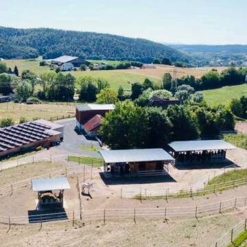
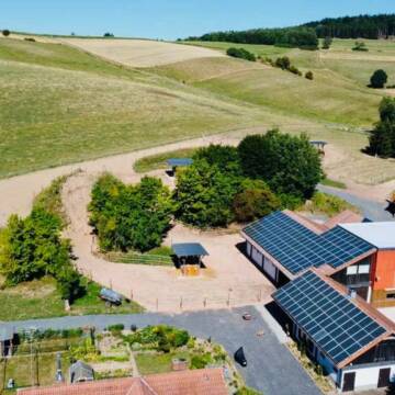
Aktivstall Offenstall Paddock Trail Plätze frei
Neuenstein
carsten-bernhardt
@carsten-bernhardt
Vermieten
Hunde willkommen
Krankenbox
Allergikerstall
Hufrehe geeignet
Bewegungsstall
Laufstall
14 weitere...
S


Pferdepension Hof Reinbold
Fritzlar
Hof-Reinbold
@Hof-Reinbold
Freizeitstall
Pferdeausbildung
Vermieten
Hunde willkommen
Krankenbox
Gnadenbrothof
Hufrehe geeignet
32 weitere...
P+
Deprecated: Creation of dynamic property Zend_View_Helper_Ads::$adLink is deprecated in /var/www/stall-frei/htdocs/staging.stall-frei.de/library/Psf/View/Helper/Ads.php on line 108

Futtersack HeuToy, Fressbremse in pink
Mechtersen
STALL-FREIde Marketing
@STALL-FREI-Marketing
Stundenlange Beschäftigung die
Koliken vorbeugt, geringe Staubinhalation mit
steuerbarer Futterentnahme
Leider kein Vorschaubild
Leider kein Vorschaubild
Sommerweide,ideal für ältere Pferde/Ponys...
Borken
Engeldinger
@Engeldinger
Geländestrecke
Pferdeausbildung
Longierzirkel/Roundpen
Paddock
Hengsthaltung möglich
Pferdezucht
Außenbox mit Paddock
Außenboxen
11 weitere...
B
Leider kein Vorschaubild
Leider kein Vorschaubild
Biete: Pensionsplätze für Pferde inkl. Halle/Wei...
Borken
Engeldinger
@Engeldinger
Kinderreitkurse
Natural Horsemanship
Beratung rund ums Pferd
Tierkommunikation
5 weitere...
B

Silent Oak Ranch – Reha & Requitreat
Jesberg
Silent Oak Ranch - Requitreat
@SilentOakRanch
Freizeitstall
Geländestrecke
Vermieten
Verpachten
Hunde willkommen
Krankenbox
Allergikerstall
Fohlenaufzucht möglich
33 weitere...
P
Leider kein Vorschaubild
Leider kein Vorschaubild
Offenstall, Paddock Box,
Wabern
DBraun
@DBraun
Freizeitstall
Vermieten
Longierzirkel/Roundpen
Paddock
Allergikerstall
bedampftes/gewaschenes Heu
13 weitere...
B
Leider kein Vorschaubild
Leider kein Vorschaubild
Offenstallplatz
Schwalmstadt
Sabine Schwalm
@Schwalm
Fahrstall, Kutschwagen
Freizeitstall
Vermieten
Krankenbox
Longierzirkel/Roundpen
Fohlenaufzucht möglich
Gnadenbrothof
17 weitere...
B

Beisteller Platz, Offenstall + Box
Felsberg
Loretta
@Loretta
Freizeitstall
Geländestrecke
Vermieten
Hunde willkommen
Toilette vorhanden
Hufrehe geeignet
8 weitere...
P

Persönlichkeitsentwicklung mit Pferden
Bad Salzuflen
Katja Dors
@Pferdezeiten
Begleite andere auf ihrem Entwicklungsweg und entdecke die transformative Kraft der pferdegestützten Persönlichkeitsentwicklung !
neu
R

Offenstallplätze frei
Willingshausen-Loshausen
Pensionsstall-Klinkenmuehle
@Pensionsstall-Klinkenmuehle
Freizeitstall
Pferdeausbildung
Vermieten
Verpachten
Hunde willkommen
Krankenbox
bedampftes/gewaschenes Heu
Fohlenaufzucht möglich
25 weitere...
aktuell
P

Pferdebox, Paddockbox, Allergikerbox frei
Malsfeld
Gestüt Lindenhof
@Gestuet-Lindenhof
FN-Mitglied
Pferdeausbildung
Vermieten
Führanlage
Krankenbox
Allergikerstall
Fohlenaufzucht möglich
24 weitere...
P
Deprecated: Creation of dynamic property Zend_View::$pageCount is deprecated in /var/www/stall-frei/htdocs/staging.stall-frei.de/library/vendor/shardj/zf1-future/library/Zend/View/Abstract.php on line 308
Deprecated: Creation of dynamic property Zend_View::$itemCountPerPage is deprecated in /var/www/stall-frei/htdocs/staging.stall-frei.de/library/vendor/shardj/zf1-future/library/Zend/View/Abstract.php on line 308
Deprecated: Creation of dynamic property Zend_View::$first is deprecated in /var/www/stall-frei/htdocs/staging.stall-frei.de/library/vendor/shardj/zf1-future/library/Zend/View/Abstract.php on line 308
Deprecated: Creation of dynamic property Zend_View::$current is deprecated in /var/www/stall-frei/htdocs/staging.stall-frei.de/library/vendor/shardj/zf1-future/library/Zend/View/Abstract.php on line 308
Deprecated: Creation of dynamic property Zend_View::$last is deprecated in /var/www/stall-frei/htdocs/staging.stall-frei.de/library/vendor/shardj/zf1-future/library/Zend/View/Abstract.php on line 308
Deprecated: Creation of dynamic property Zend_View::$next is deprecated in /var/www/stall-frei/htdocs/staging.stall-frei.de/library/vendor/shardj/zf1-future/library/Zend/View/Abstract.php on line 308
Deprecated: Creation of dynamic property Zend_View::$pagesInRange is deprecated in /var/www/stall-frei/htdocs/staging.stall-frei.de/library/vendor/shardj/zf1-future/library/Zend/View/Abstract.php on line 308
Deprecated: Creation of dynamic property Zend_View::$firstPageInRange is deprecated in /var/www/stall-frei/htdocs/staging.stall-frei.de/library/vendor/shardj/zf1-future/library/Zend/View/Abstract.php on line 308
Deprecated: Creation of dynamic property Zend_View::$lastPageInRange is deprecated in /var/www/stall-frei/htdocs/staging.stall-frei.de/library/vendor/shardj/zf1-future/library/Zend/View/Abstract.php on line 308
Deprecated: Creation of dynamic property Zend_View::$currentItemCount is deprecated in /var/www/stall-frei/htdocs/staging.stall-frei.de/library/vendor/shardj/zf1-future/library/Zend/View/Abstract.php on line 308
Deprecated: Creation of dynamic property Zend_View::$totalItemCount is deprecated in /var/www/stall-frei/htdocs/staging.stall-frei.de/library/vendor/shardj/zf1-future/library/Zend/View/Abstract.php on line 308
Deprecated: Creation of dynamic property Zend_View::$firstItemNumber is deprecated in /var/www/stall-frei/htdocs/staging.stall-frei.de/library/vendor/shardj/zf1-future/library/Zend/View/Abstract.php on line 308
Deprecated: Creation of dynamic property Zend_View::$lastItemNumber is deprecated in /var/www/stall-frei/htdocs/staging.stall-frei.de/library/vendor/shardj/zf1-future/library/Zend/View/Abstract.php on line 308
Deprecated: Creation of dynamic property Zend_View::$router is deprecated in /var/www/stall-frei/htdocs/staging.stall-frei.de/library/vendor/shardj/zf1-future/library/Zend/View/Abstract.php on line 308
Deprecated: Creation of dynamic property Zend_View::$urlParams is deprecated in /var/www/stall-frei/htdocs/staging.stall-frei.de/library/vendor/shardj/zf1-future/library/Zend/View/Abstract.php on line 308
Deprecated: Creation of dynamic property Zend_View::$showAds is deprecated in /var/www/stall-frei/htdocs/staging.stall-frei.de/library/vendor/shardj/zf1-future/library/Zend/View/Abstract.php on line 308
Deprecated: Creation of dynamic property Zend_View::$objectIds is deprecated in /var/www/stall-frei/htdocs/staging.stall-frei.de/library/vendor/shardj/zf1-future/library/Zend/View/Abstract.php on line 308
Deprecated: Creation of dynamic property Zend_View::$showNavbar is deprecated in /var/www/stall-frei/htdocs/staging.stall-frei.de/library/vendor/shardj/zf1-future/library/Zend/View/Abstract.php on line 308
Deprecated: Creation of dynamic property Zend_View::$showBreadcrumb is deprecated in /var/www/stall-frei/htdocs/staging.stall-frei.de/library/vendor/shardj/zf1-future/library/Zend/View/Abstract.php on line 308
Deprecated: Creation of dynamic property Zend_View::$showFooter is deprecated in /var/www/stall-frei/htdocs/staging.stall-frei.de/library/vendor/shardj/zf1-future/library/Zend/View/Abstract.php on line 308
Deprecated: Creation of dynamic property Zend_View::$showInternalAds is deprecated in /var/www/stall-frei/htdocs/staging.stall-frei.de/library/vendor/shardj/zf1-future/library/Zend/View/Abstract.php on line 308
Deprecated: Creation of dynamic property Zend_View::$blNoContent is deprecated in /var/www/stall-frei/htdocs/staging.stall-frei.de/library/vendor/shardj/zf1-future/library/Zend/View/Abstract.php on line 308
Deprecated: Creation of dynamic property Zend_View::$sMetaDesc is deprecated in /var/www/stall-frei/htdocs/staging.stall-frei.de/library/vendor/shardj/zf1-future/library/Zend/View/Abstract.php on line 308
Deprecated: Creation of dynamic property Zend_View::$useGmaps is deprecated in /var/www/stall-frei/htdocs/staging.stall-frei.de/library/vendor/shardj/zf1-future/library/Zend/View/Abstract.php on line 308
Deprecated: Creation of dynamic property Zend_View::$touches is deprecated in /var/www/stall-frei/htdocs/staging.stall-frei.de/library/vendor/shardj/zf1-future/library/Zend/View/Abstract.php on line 308
Deprecated: Creation of dynamic property Zend_View::$oProject is deprecated in /var/www/stall-frei/htdocs/staging.stall-frei.de/library/vendor/shardj/zf1-future/library/Zend/View/Abstract.php on line 308
Deprecated: Creation of dynamic property Zend_View::$pageHeadline is deprecated in /var/www/stall-frei/htdocs/staging.stall-frei.de/library/vendor/shardj/zf1-future/library/Zend/View/Abstract.php on line 308
Deprecated: Creation of dynamic property Zend_View::$disableLocationField is deprecated in /var/www/stall-frei/htdocs/staging.stall-frei.de/library/vendor/shardj/zf1-future/library/Zend/View/Abstract.php on line 308
Deprecated: Creation of dynamic property Zend_View::$isSearch is deprecated in /var/www/stall-frei/htdocs/staging.stall-frei.de/library/vendor/shardj/zf1-future/library/Zend/View/Abstract.php on line 308
Deprecated: Creation of dynamic property Zend_View::$pageTitle is deprecated in /var/www/stall-frei/htdocs/staging.stall-frei.de/library/vendor/shardj/zf1-future/library/Zend/View/Abstract.php on line 308
Deprecated: Creation of dynamic property Psf_Form_Element_Text::$class is deprecated in /var/www/stall-frei/htdocs/staging.stall-frei.de/library/vendor/shardj/zf1-future/library/Zend/Form/Element.php on line 874
Deprecated: Creation of dynamic property Psf_Form_Element_Text::$size is deprecated in /var/www/stall-frei/htdocs/staging.stall-frei.de/library/vendor/shardj/zf1-future/library/Zend/Form/Element.php on line 874
Deprecated: Creation of dynamic property Psf_Form_Element_Text::$placeholder is deprecated in /var/www/stall-frei/htdocs/staging.stall-frei.de/library/vendor/shardj/zf1-future/library/Zend/Form/Element.php on line 874
Deprecated: Creation of dynamic property Psf_Form_Element_Hidden::$class is deprecated in /var/www/stall-frei/htdocs/staging.stall-frei.de/library/vendor/shardj/zf1-future/library/Zend/Form/Element.php on line 874
Deprecated: Creation of dynamic property Psf_Form_Element_Hidden::$class is deprecated in /var/www/stall-frei/htdocs/staging.stall-frei.de/library/vendor/shardj/zf1-future/library/Zend/Form/Element.php on line 874
Deprecated: Creation of dynamic property Psf_Form_Element_Hidden::$class is deprecated in /var/www/stall-frei/htdocs/staging.stall-frei.de/library/vendor/shardj/zf1-future/library/Zend/Form/Element.php on line 874
Deprecated: Creation of dynamic property Psf_Form_Element_Hidden::$class is deprecated in /var/www/stall-frei/htdocs/staging.stall-frei.de/library/vendor/shardj/zf1-future/library/Zend/Form/Element.php on line 874
Deprecated: Creation of dynamic property Psf_Form_Element_Select::$class is deprecated in /var/www/stall-frei/htdocs/staging.stall-frei.de/library/vendor/shardj/zf1-future/library/Zend/Form/Element.php on line 874
Deprecated: Creation of dynamic property Psf_Form_Element_Select::$class is deprecated in /var/www/stall-frei/htdocs/staging.stall-frei.de/library/vendor/shardj/zf1-future/library/Zend/Form/Element.php on line 874
Deprecated: Creation of dynamic property Psf_Form_Element_Select::$class is deprecated in /var/www/stall-frei/htdocs/staging.stall-frei.de/library/vendor/shardj/zf1-future/library/Zend/Form/Element.php on line 874
Deprecated: Creation of dynamic property Psf_Form_Element_Select::$class is deprecated in /var/www/stall-frei/htdocs/staging.stall-frei.de/library/vendor/shardj/zf1-future/library/Zend/Form/Element.php on line 874
Deprecated: Creation of dynamic property Psf_Form_Element_Text::$class is deprecated in /var/www/stall-frei/htdocs/staging.stall-frei.de/library/vendor/shardj/zf1-future/library/Zend/Form/Element.php on line 874
Deprecated: Creation of dynamic property Psf_Form_Element_Checkbox::$label is deprecated in /var/www/stall-frei/htdocs/staging.stall-frei.de/library/vendor/shardj/zf1-future/library/Zend/Form/Element.php on line 874
Deprecated: Creation of dynamic property Zend_View::$sort is deprecated in /var/www/stall-frei/htdocs/staging.stall-frei.de/library/vendor/shardj/zf1-future/library/Zend/View/Abstract.php on line 308
Deprecated: Creation of dynamic property Zend_View::$searchLocation is deprecated in /var/www/stall-frei/htdocs/staging.stall-frei.de/library/vendor/shardj/zf1-future/library/Zend/View/Abstract.php on line 308
Deprecated: Creation of dynamic property Zend_View::$locationHint is deprecated in /var/www/stall-frei/htdocs/staging.stall-frei.de/library/vendor/shardj/zf1-future/library/Zend/View/Abstract.php on line 308
Psf_GeoCoder_Abstract::getLocation: Freudenthal Get Location CachedOrLive
Psf_GeoCoder_Abstract::getCachedOrLive: Freudenthal
Psf_GeoCoder_OpenCageData::makeApiRequest: response:
Array
(
[documentation] => https://opencagedata.com/api
[licenses] => Array
(
[0] => Array
(
[name] => see attribution guide
[url] => https://opencagedata.com/credits
)
)
[results] => Array
(
[0] => Array
(
[bounds] => Array
(
[northeast] => Array
(
[lat] => 51.0401047
[lng] => 9.340395
)
[southwest] => Array
(
[lat] => 51.0137129
[lng] => 9.3142781
)
)
[components] => Array
(
[ISO_3166-1_alpha-2] => DE
[ISO_3166-1_alpha-3] => DEU
[ISO_3166-2] => Array
(
[0] => DE-HE
)
[_category] => place
[_normalized_city] => Freudenthal
[_type] => village
[continent] => Europe
[country] => Deutschland
[country_code] => de
[county] => Schwalm-Eder-Kreis
[municipality] => Borken (Hessen)
[political_union] => European Union
[state] => Hessen
[state_code] => HE
[village] => Freudenthal
)
[confidence] => 7
[formatted] => Freudenthal, Hessen, Deutschland
[geometry] => Array
(
[lat] => 51.0249939
[lng] => 9.3270345
)
)
[1] => Array
(
[bounds] => Array
(
[northeast] => Array
(
[lat] => 51.3802329
[lng] => 9.851604
)
[southwest] => Array
(
[lat] => 51.3402329
[lng] => 9.811604
)
)
[components] => Array
(
[ISO_3166-1_alpha-2] => DE
[ISO_3166-1_alpha-3] => DEU
[ISO_3166-2] => Array
(
[0] => DE-HE
)
[_category] => place
[_normalized_city] => Ermschwerd
[_type] => hamlet
[continent] => Europe
[country] => Deutschland
[country_code] => de
[county] => Werra-Meißner-Kreis
[hamlet] => Freudenthal
[municipality] => Witzenhausen
[political_union] => European Union
[postcode] => 37218
[state] => Hessen
[state_code] => HE
[village] => Ermschwerd
)
[confidence] => 7
[formatted] => Freudenthal, 37218 Ermschwerd, Deutschland
[geometry] => Array
(
[lat] => 51.3602329
[lng] => 9.831604
)
)
[2] => Array
(
[bounds] => Array
(
[northeast] => Array
(
[lat] => 48.7144455
[lng] => 11.9059162
)
[southwest] => Array
(
[lat] => 48.6744455
[lng] => 11.8659162
)
)
[components] => Array
(
[ISO_3166-1_alpha-2] => DE
[ISO_3166-1_alpha-3] => DEU
[ISO_3166-2] => Array
(
[0] => DE-BY
)
[_category] => place
[_normalized_city] => Elsendorf
[_type] => hamlet
[continent] => Europe
[country] => Deutschland
[country_code] => de
[county] => Landkreis Kelheim
[hamlet] => Freudenthal
[municipality] => Mainburg (VGem)
[political_union] => European Union
[postcode] => 84094
[state] => Bayern
[state_code] => BY
[village] => Elsendorf
)
[confidence] => 7
[formatted] => Freudenthal, 84094 Elsendorf, Deutschland
[geometry] => Array
(
[lat] => 48.6944455
[lng] => 11.8859162
)
)
[3] => Array
(
[bounds] => Array
(
[northeast] => Array
(
[lat] => 54.3763577
[lng] => 9.6838767
)
[southwest] => Array
(
[lat] => 54.3762577
[lng] => 9.6837767
)
)
[components] => Array
(
[ISO_3166-1_alpha-2] => DE
[ISO_3166-1_alpha-3] => DEU
[ISO_3166-2] => Array
(
[0] => DE-SH
)
[_category] => building
[_normalized_city] => Holzbunge
[_type] => building
[continent] => Europe
[country] => Deutschland
[country_code] => de
[county] => Kreis Rendsburg-Eckernförde
[isolated_dwelling] => Freudenthal
[municipality] => Hüttener Berge
[political_union] => European Union
[postcode] => 24361
[state] => Schleswig-Holstein
[state_code] => SH
[village] => Holzbunge
)
[confidence] => 10
[formatted] => Freudenthal, 24361 Holzbunge, Deutschland
[geometry] => Array
(
[lat] => 54.3763077
[lng] => 9.6838267
)
)
[4] => Array
(
[bounds] => Array
(
[northeast] => Array
(
[lat] => 50.8834953
[lng] => 10.8440043
)
[southwest] => Array
(
[lat] => 50.8818418
[lng] => 10.8407081
)
)
[components] => Array
(
[ISO_3166-1_alpha-2] => DE
[ISO_3166-1_alpha-3] => DEU
[ISO_3166-2] => Array
(
[0] => DE-TH
)
[_category] => place
[_normalized_city] => Wandersleben
[_type] => hamlet
[continent] => Europe
[country] => Deutschland
[country_code] => de
[county] => Landkreis Gotha
[locality] => Freudenthal
[municipality] => Drei Gleichen
[political_union] => European Union
[postcode] => 99869
[state] => Thüringen
[state_code] => TH
[village] => Wandersleben
)
[confidence] => 9
[formatted] => Freudenthal, 99869 Wandersleben, Deutschland
[geometry] => Array
(
[lat] => 50.8826615
[lng] => 10.8424228
)
)
[5] => Array
(
[bounds] => Array
(
[northeast] => Array
(
[lat] => 50.8880559
[lng] => 10.8474712
)
[southwest] => Array
(
[lat] => 50.8844529
[lng] => 10.8436995
)
)
[components] => Array
(
[ISO_3166-1_alpha-2] => DE
[ISO_3166-1_alpha-3] => DEU
[ISO_3166-2] => Array
(
[0] => DE-TH
)
[_category] => road
[_normalized_city] => Wandersleben
[_type] => road
[continent] => Europe
[country] => Deutschland
[country_code] => de
[county] => Landkreis Gotha
[municipality] => Drei Gleichen
[political_union] => European Union
[postcode] => 99869
[road] => Freudenthal
[road_type] => secondary
[state] => Thüringen
[state_code] => TH
[village] => Wandersleben
)
[confidence] => 9
[formatted] => Freudenthal, 99869 Wandersleben, Deutschland
[geometry] => Array
(
[lat] => 50.88576
[lng] => 10.8460673
)
)
[6] => Array
(
[bounds] => Array
(
[northeast] => Array
(
[lat] => 54.1480361
[lng] => 9.2783047
)
[southwest] => Array
(
[lat] => 54.1465611
[lng] => 9.2729671
)
)
[components] => Array
(
[ISO_3166-1_alpha-2] => DE
[ISO_3166-1_alpha-3] => DEU
[ISO_3166-2] => Array
(
[0] => DE-SH
)
[_category] => road
[_normalized_city] => Albersdorf
[_type] => road
[continent] => Europe
[country] => Deutschland
[country_code] => de
[county] => Kreis Dithmarschen
[municipality] => Mitteldithmarschen
[political_union] => European Union
[postcode] => 25767
[road] => Freudenthal
[road_type] => residential
[state] => Schleswig-Holstein
[state_code] => SH
[town] => Albersdorf
)
[confidence] => 9
[formatted] => Freudenthal, 25767 Albersdorf, Deutschland
[geometry] => Array
(
[lat] => 54.1469821
[lng] => 9.2757493
)
)
[7] => Array
(
[bounds] => Array
(
[northeast] => Array
(
[lat] => 54.3758736
[lng] => 9.6946528
)
[southwest] => Array
(
[lat] => 54.3753386
[lng] => 9.6863202
)
)
[components] => Array
(
[ISO_3166-1_alpha-2] => DE
[ISO_3166-1_alpha-3] => DEU
[ISO_3166-2] => Array
(
[0] => DE-SH
)
[_category] => road
[_normalized_city] => Holzbunge
[_type] => road
[continent] => Europe
[country] => Deutschland
[country_code] => de
[county] => Kreis Rendsburg-Eckernförde
[municipality] => Hüttener Berge
[political_union] => European Union
[postcode] => 24361
[road] => Freudenthal
[road_type] => track
[state] => Schleswig-Holstein
[state_code] => SH
[village] => Holzbunge
)
[confidence] => 9
[formatted] => Freudenthal, 24361 Holzbunge, Deutschland
[geometry] => Array
(
[lat] => 54.3756904
[lng] => 9.6904741
)
)
[8] => Array
(
[bounds] => Array
(
[northeast] => Array
(
[lat] => 52.2536025
[lng] => 13.6614508
)
[southwest] => Array
(
[lat] => 52.2516966
[lng] => 13.6597758
)
)
[components] => Array
(
[ISO_3166-1_alpha-2] => DE
[ISO_3166-1_alpha-3] => DEU
[ISO_3166-2] => Array
(
[0] => DE-BB
)
[_category] => road
[_normalized_city] => Bestensee
[_type] => road
[continent] => Europe
[country] => Deutschland
[country_code] => de
[county] => Dahme-Spreewald
[hamlet] => Glunzbusch
[municipality] => Schenkendorf-Krummensee
[political_union] => European Union
[postcode] => 15741
[road] => Freudenthal
[road_type] => residential
[state] => Brandenburg
[state_code] => BB
[village] => Bestensee
)
[confidence] => 9
[formatted] => Freudenthal, 15741 Bestensee, Deutschland
[geometry] => Array
(
[lat] => 52.2525449
[lng] => 13.6607549
)
)
[9] => Array
(
[components] => Array
(
[ISO_3166-1_alpha-2] => FR
[ISO_3166-1_alpha-3] => FRA
[ISO_3166-2] => Array
(
[0] => FR-IDF
[1] => FR-92
)
[_category] => road
[_normalized_city] => Levallois-Perret
[_type] => road
[city] => Levallois-Perret
[continent] => Europe
[country] => France
[country_code] => fr
[county] => Hauts-de-Seine
[local_authority] => Métropole du Grand Paris
[political_union] => European Union
[postcode] => 92300
[road] => Rue Charles Deutschmann
[state] => Île-de-France
[state_code] => IDF
)
[confidence] => 2
[formatted] => Rue Charles Deutschmann, 92300 Levallois-Perret, France
[geometry] => Array
(
[lat] => 48.900049
[lng] => 2.2842
)
)
)
[status] => Array
(
[code] => 200
[message] => OK
)
[stay_informed] => Array
(
[blog] => https://blog.opencagedata.com
[mastodon] => https://en.osm.town/@opencage
)
[thanks] => For using an OpenCage API
[timestamp] => Array
(
[created_http] => Sun, 08 Feb 2026 13:49:15 GMT
[created_unix] => 1770558555
)
[total_results] => 10
)
Psf_GeoCoder_Abstract::convertLocationResult
{"documentation":"https:\/\/opencagedata.com\/api","licenses":[{"name":"see attribution guide","url":"https:\/\/opencagedata.com\/credits"}],"results":[{"bounds":{"northeast":{"lat":51.0401047,"lng":9.340395},"southwest":{"lat":51.0137129,"lng":9.3142781}},"components":{"ISO_3166-1_alpha-2":"DE","ISO_3166-1_alpha-3":"DEU","ISO_3166-2":["DE-HE"],"_category":"place","_normalized_city":"Freudenthal","_type":"village","continent":"Europe","country":"Deutschland","country_code":"de","county":"Schwalm-Eder-Kreis","municipality":"Borken (Hessen)","political_union":"European Union","state":"Hessen","state_code":"HE","village":"Freudenthal"},"confidence":7,"formatted":"Freudenthal, Hessen, Deutschland","geometry":{"lat":51.0249939,"lng":9.3270345}},{"bounds":{"northeast":{"lat":51.3802329,"lng":9.851604},"southwest":{"lat":51.3402329,"lng":9.811604}},"components":{"ISO_3166-1_alpha-2":"DE","ISO_3166-1_alpha-3":"DEU","ISO_3166-2":["DE-HE"],"_category":"place","_normalized_city":"Ermschwerd","_type":"hamlet","continent":"Europe","country":"Deutschland","country_code":"de","county":"Werra-Mei\u00dfner-Kreis","hamlet":"Freudenthal","municipality":"Witzenhausen","political_union":"European Union","postcode":"37218","state":"Hessen","state_code":"HE","village":"Ermschwerd"},"confidence":7,"formatted":"Freudenthal, 37218 Ermschwerd, Deutschland","geometry":{"lat":51.3602329,"lng":9.831604}},{"bounds":{"northeast":{"lat":48.7144455,"lng":11.9059162},"southwest":{"lat":48.6744455,"lng":11.8659162}},"components":{"ISO_3166-1_alpha-2":"DE","ISO_3166-1_alpha-3":"DEU","ISO_3166-2":["DE-BY"],"_category":"place","_normalized_city":"Elsendorf","_type":"hamlet","continent":"Europe","country":"Deutschland","country_code":"de","county":"Landkreis Kelheim","hamlet":"Freudenthal","municipality":"Mainburg (VGem)","political_union":"European Union","postcode":"84094","state":"Bayern","state_code":"BY","village":"Elsendorf"},"confidence":7,"formatted":"Freudenthal, 84094 Elsendorf, Deutschland","geometry":{"lat":48.6944455,"lng":11.8859162}},{"bounds":{"northeast":{"lat":54.3763577,"lng":9.6838767},"southwest":{"lat":54.3762577,"lng":9.6837767}},"components":{"ISO_3166-1_alpha-2":"DE","ISO_3166-1_alpha-3":"DEU","ISO_3166-2":["DE-SH"],"_category":"building","_normalized_city":"Holzbunge","_type":"building","continent":"Europe","country":"Deutschland","country_code":"de","county":"Kreis Rendsburg-Eckernf\u00f6rde","isolated_dwelling":"Freudenthal","municipality":"H\u00fcttener Berge","political_union":"European Union","postcode":"24361","state":"Schleswig-Holstein","state_code":"SH","village":"Holzbunge"},"confidence":10,"formatted":"Freudenthal, 24361 Holzbunge, Deutschland","geometry":{"lat":54.3763077,"lng":9.6838267}},{"bounds":{"northeast":{"lat":50.8834953,"lng":10.8440043},"southwest":{"lat":50.8818418,"lng":10.8407081}},"components":{"ISO_3166-1_alpha-2":"DE","ISO_3166-1_alpha-3":"DEU","ISO_3166-2":["DE-TH"],"_category":"place","_normalized_city":"Wandersleben","_type":"hamlet","continent":"Europe","country":"Deutschland","country_code":"de","county":"Landkreis Gotha","locality":"Freudenthal","municipality":"Drei Gleichen","political_union":"European Union","postcode":"99869","state":"Th\u00fcringen","state_code":"TH","village":"Wandersleben"},"confidence":9,"formatted":"Freudenthal, 99869 Wandersleben, Deutschland","geometry":{"lat":50.8826615,"lng":10.8424228}},{"bounds":{"northeast":{"lat":50.8880559,"lng":10.8474712},"southwest":{"lat":50.8844529,"lng":10.8436995}},"components":{"ISO_3166-1_alpha-2":"DE","ISO_3166-1_alpha-3":"DEU","ISO_3166-2":["DE-TH"],"_category":"road","_normalized_city":"Wandersleben","_type":"road","continent":"Europe","country":"Deutschland","country_code":"de","county":"Landkreis Gotha","municipality":"Drei Gleichen","political_union":"European Union","postcode":"99869","road":"Freudenthal","road_type":"secondary","state":"Th\u00fcringen","state_code":"TH","village":"Wandersleben"},"confidence":9,"formatted":"Freudenthal, 99869 Wandersleben, Deutschland","geometry":{"lat":50.88576,"lng":10.8460673}},{"bounds":{"northeast":{"lat":54.1480361,"lng":9.2783047},"southwest":{"lat":54.1465611,"lng":9.2729671}},"components":{"ISO_3166-1_alpha-2":"DE","ISO_3166-1_alpha-3":"DEU","ISO_3166-2":["DE-SH"],"_category":"road","_normalized_city":"Albersdorf","_type":"road","continent":"Europe","country":"Deutschland","country_code":"de","county":"Kreis Dithmarschen","municipality":"Mitteldithmarschen","political_union":"European Union","postcode":"25767","road":"Freudenthal","road_type":"residential","state":"Schleswig-Holstein","state_code":"SH","town":"Albersdorf"},"confidence":9,"formatted":"Freudenthal, 25767 Albersdorf, Deutschland","geometry":{"lat":54.1469821,"lng":9.2757493}},{"bounds":{"northeast":{"lat":54.3758736,"lng":9.6946528},"southwest":{"lat":54.3753386,"lng":9.6863202}},"components":{"ISO_3166-1_alpha-2":"DE","ISO_3166-1_alpha-3":"DEU","ISO_3166-2":["DE-SH"],"_category":"road","_normalized_city":"Holzbunge","_type":"road","continent":"Europe","country":"Deutschland","country_code":"de","county":"Kreis Rendsburg-Eckernf\u00f6rde","municipality":"H\u00fcttener Berge","political_union":"European Union","postcode":"24361","road":"Freudenthal","road_type":"track","state":"Schleswig-Holstein","state_code":"SH","village":"Holzbunge"},"confidence":9,"formatted":"Freudenthal, 24361 Holzbunge, Deutschland","geometry":{"lat":54.3756904,"lng":9.6904741}},{"bounds":{"northeast":{"lat":52.2536025,"lng":13.6614508},"southwest":{"lat":52.2516966,"lng":13.6597758}},"components":{"ISO_3166-1_alpha-2":"DE","ISO_3166-1_alpha-3":"DEU","ISO_3166-2":["DE-BB"],"_category":"road","_normalized_city":"Bestensee","_type":"road","continent":"Europe","country":"Deutschland","country_code":"de","county":"Dahme-Spreewald","hamlet":"Glunzbusch","municipality":"Schenkendorf-Krummensee","political_union":"European Union","postcode":"15741","road":"Freudenthal","road_type":"residential","state":"Brandenburg","state_code":"BB","village":"Bestensee"},"confidence":9,"formatted":"Freudenthal, 15741 Bestensee, Deutschland","geometry":{"lat":52.2525449,"lng":13.6607549}},{"components":{"ISO_3166-1_alpha-2":"FR","ISO_3166-1_alpha-3":"FRA","ISO_3166-2":["FR-IDF","FR-92"],"_category":"road","_normalized_city":"Levallois-Perret","_type":"road","city":"Levallois-Perret","continent":"Europe","country":"France","country_code":"fr","county":"Hauts-de-Seine","local_authority":"M\u00e9tropole du Grand Paris","political_union":"European Union","postcode":"92300","road":"Rue Charles Deutschmann","state":"\u00cele-de-France","state_code":"IDF"},"confidence":2,"formatted":"Rue Charles Deutschmann, 92300 Levallois-Perret, France","geometry":{"lat":48.900049,"lng":2.2842}}],"status":{"code":200,"message":"OK"},"stay_informed":{"blog":"https:\/\/blog.opencagedata.com","mastodon":"https:\/\/en.osm.town\/@opencage"},"thanks":"For using an OpenCage API","timestamp":{"created_http":"Sun, 08 Feb 2026 13:49:15 GMT","created_unix":1770558555},"total_results":10}Array
(
[0] => stdClass Object
(
[bounds] => stdClass Object
(
[northeast] => stdClass Object
(
[lat] => 51.0401047
[lng] => 9.340395
)
[southwest] => stdClass Object
(
[lat] => 51.0137129
[lng] => 9.3142781
)
)
[components] => stdClass Object
(
[ISO_3166-1_alpha-2] => DE
[ISO_3166-1_alpha-3] => DEU
[ISO_3166-2] => Array
(
[0] => DE-HE
)
[_category] => place
[_normalized_city] => Freudenthal
[_type] => village
[continent] => Europe
[country] => Deutschland
[country_code] => de
[county] => Schwalm-Eder-Kreis
[municipality] => Borken (Hessen)
[political_union] => European Union
[state] => Hessen
[state_code] => HE
[village] => Freudenthal
)
[confidence] => 7
[formatted] => Freudenthal, Hessen, Deutschland
[geometry] => stdClass Object
(
[lat] => 51.0249939
[lng] => 9.3270345
)
)
[1] => stdClass Object
(
[bounds] => stdClass Object
(
[northeast] => stdClass Object
(
[lat] => 51.3802329
[lng] => 9.851604
)
[southwest] => stdClass Object
(
[lat] => 51.3402329
[lng] => 9.811604
)
)
[components] => stdClass Object
(
[ISO_3166-1_alpha-2] => DE
[ISO_3166-1_alpha-3] => DEU
[ISO_3166-2] => Array
(
[0] => DE-HE
)
[_category] => place
[_normalized_city] => Ermschwerd
[_type] => hamlet
[continent] => Europe
[country] => Deutschland
[country_code] => de
[county] => Werra-Meißner-Kreis
[hamlet] => Freudenthal
[municipality] => Witzenhausen
[political_union] => European Union
[postcode] => 37218
[state] => Hessen
[state_code] => HE
[village] => Ermschwerd
)
[confidence] => 7
[formatted] => Freudenthal, 37218 Ermschwerd, Deutschland
[geometry] => stdClass Object
(
[lat] => 51.3602329
[lng] => 9.831604
)
)
[2] => stdClass Object
(
[bounds] => stdClass Object
(
[northeast] => stdClass Object
(
[lat] => 48.7144455
[lng] => 11.9059162
)
[southwest] => stdClass Object
(
[lat] => 48.6744455
[lng] => 11.8659162
)
)
[components] => stdClass Object
(
[ISO_3166-1_alpha-2] => DE
[ISO_3166-1_alpha-3] => DEU
[ISO_3166-2] => Array
(
[0] => DE-BY
)
[_category] => place
[_normalized_city] => Elsendorf
[_type] => hamlet
[continent] => Europe
[country] => Deutschland
[country_code] => de
[county] => Landkreis Kelheim
[hamlet] => Freudenthal
[municipality] => Mainburg (VGem)
[political_union] => European Union
[postcode] => 84094
[state] => Bayern
[state_code] => BY
[village] => Elsendorf
)
[confidence] => 7
[formatted] => Freudenthal, 84094 Elsendorf, Deutschland
[geometry] => stdClass Object
(
[lat] => 48.6944455
[lng] => 11.8859162
)
)
[3] => stdClass Object
(
[bounds] => stdClass Object
(
[northeast] => stdClass Object
(
[lat] => 54.3763577
[lng] => 9.6838767
)
[southwest] => stdClass Object
(
[lat] => 54.3762577
[lng] => 9.6837767
)
)
[components] => stdClass Object
(
[ISO_3166-1_alpha-2] => DE
[ISO_3166-1_alpha-3] => DEU
[ISO_3166-2] => Array
(
[0] => DE-SH
)
[_category] => building
[_normalized_city] => Holzbunge
[_type] => building
[continent] => Europe
[country] => Deutschland
[country_code] => de
[county] => Kreis Rendsburg-Eckernförde
[isolated_dwelling] => Freudenthal
[municipality] => Hüttener Berge
[political_union] => European Union
[postcode] => 24361
[state] => Schleswig-Holstein
[state_code] => SH
[village] => Holzbunge
)
[confidence] => 10
[formatted] => Freudenthal, 24361 Holzbunge, Deutschland
[geometry] => stdClass Object
(
[lat] => 54.3763077
[lng] => 9.6838267
)
)
[4] => stdClass Object
(
[bounds] => stdClass Object
(
[northeast] => stdClass Object
(
[lat] => 50.8834953
[lng] => 10.8440043
)
[southwest] => stdClass Object
(
[lat] => 50.8818418
[lng] => 10.8407081
)
)
[components] => stdClass Object
(
[ISO_3166-1_alpha-2] => DE
[ISO_3166-1_alpha-3] => DEU
[ISO_3166-2] => Array
(
[0] => DE-TH
)
[_category] => place
[_normalized_city] => Wandersleben
[_type] => hamlet
[continent] => Europe
[country] => Deutschland
[country_code] => de
[county] => Landkreis Gotha
[locality] => Freudenthal
[municipality] => Drei Gleichen
[political_union] => European Union
[postcode] => 99869
[state] => Thüringen
[state_code] => TH
[village] => Wandersleben
)
[confidence] => 9
[formatted] => Freudenthal, 99869 Wandersleben, Deutschland
[geometry] => stdClass Object
(
[lat] => 50.8826615
[lng] => 10.8424228
)
)
[5] => stdClass Object
(
[bounds] => stdClass Object
(
[northeast] => stdClass Object
(
[lat] => 50.8880559
[lng] => 10.8474712
)
[southwest] => stdClass Object
(
[lat] => 50.8844529
[lng] => 10.8436995
)
)
[components] => stdClass Object
(
[ISO_3166-1_alpha-2] => DE
[ISO_3166-1_alpha-3] => DEU
[ISO_3166-2] => Array
(
[0] => DE-TH
)
[_category] => road
[_normalized_city] => Wandersleben
[_type] => road
[continent] => Europe
[country] => Deutschland
[country_code] => de
[county] => Landkreis Gotha
[municipality] => Drei Gleichen
[political_union] => European Union
[postcode] => 99869
[road] => Freudenthal
[road_type] => secondary
[state] => Thüringen
[state_code] => TH
[village] => Wandersleben
)
[confidence] => 9
[formatted] => Freudenthal, 99869 Wandersleben, Deutschland
[geometry] => stdClass Object
(
[lat] => 50.88576
[lng] => 10.8460673
)
)
[6] => stdClass Object
(
[bounds] => stdClass Object
(
[northeast] => stdClass Object
(
[lat] => 54.1480361
[lng] => 9.2783047
)
[southwest] => stdClass Object
(
[lat] => 54.1465611
[lng] => 9.2729671
)
)
[components] => stdClass Object
(
[ISO_3166-1_alpha-2] => DE
[ISO_3166-1_alpha-3] => DEU
[ISO_3166-2] => Array
(
[0] => DE-SH
)
[_category] => road
[_normalized_city] => Albersdorf
[_type] => road
[continent] => Europe
[country] => Deutschland
[country_code] => de
[county] => Kreis Dithmarschen
[municipality] => Mitteldithmarschen
[political_union] => European Union
[postcode] => 25767
[road] => Freudenthal
[road_type] => residential
[state] => Schleswig-Holstein
[state_code] => SH
[town] => Albersdorf
)
[confidence] => 9
[formatted] => Freudenthal, 25767 Albersdorf, Deutschland
[geometry] => stdClass Object
(
[lat] => 54.1469821
[lng] => 9.2757493
)
)
[7] => stdClass Object
(
[bounds] => stdClass Object
(
[northeast] => stdClass Object
(
[lat] => 54.3758736
[lng] => 9.6946528
)
[southwest] => stdClass Object
(
[lat] => 54.3753386
[lng] => 9.6863202
)
)
[components] => stdClass Object
(
[ISO_3166-1_alpha-2] => DE
[ISO_3166-1_alpha-3] => DEU
[ISO_3166-2] => Array
(
[0] => DE-SH
)
[_category] => road
[_normalized_city] => Holzbunge
[_type] => road
[continent] => Europe
[country] => Deutschland
[country_code] => de
[county] => Kreis Rendsburg-Eckernförde
[municipality] => Hüttener Berge
[political_union] => European Union
[postcode] => 24361
[road] => Freudenthal
[road_type] => track
[state] => Schleswig-Holstein
[state_code] => SH
[village] => Holzbunge
)
[confidence] => 9
[formatted] => Freudenthal, 24361 Holzbunge, Deutschland
[geometry] => stdClass Object
(
[lat] => 54.3756904
[lng] => 9.6904741
)
)
[8] => stdClass Object
(
[bounds] => stdClass Object
(
[northeast] => stdClass Object
(
[lat] => 52.2536025
[lng] => 13.6614508
)
[southwest] => stdClass Object
(
[lat] => 52.2516966
[lng] => 13.6597758
)
)
[components] => stdClass Object
(
[ISO_3166-1_alpha-2] => DE
[ISO_3166-1_alpha-3] => DEU
[ISO_3166-2] => Array
(
[0] => DE-BB
)
[_category] => road
[_normalized_city] => Bestensee
[_type] => road
[continent] => Europe
[country] => Deutschland
[country_code] => de
[county] => Dahme-Spreewald
[hamlet] => Glunzbusch
[municipality] => Schenkendorf-Krummensee
[political_union] => European Union
[postcode] => 15741
[road] => Freudenthal
[road_type] => residential
[state] => Brandenburg
[state_code] => BB
[village] => Bestensee
)
[confidence] => 9
[formatted] => Freudenthal, 15741 Bestensee, Deutschland
[geometry] => stdClass Object
(
[lat] => 52.2525449
[lng] => 13.6607549
)
)
[9] => stdClass Object
(
[components] => stdClass Object
(
[ISO_3166-1_alpha-2] => FR
[ISO_3166-1_alpha-3] => FRA
[ISO_3166-2] => Array
(
[0] => FR-IDF
[1] => FR-92
)
[_category] => road
[_normalized_city] => Levallois-Perret
[_type] => road
[city] => Levallois-Perret
[continent] => Europe
[country] => France
[country_code] => fr
[county] => Hauts-de-Seine
[local_authority] => Métropole du Grand Paris
[political_union] => European Union
[postcode] => 92300
[road] => Rue Charles Deutschmann
[state] => Île-de-France
[state_code] => IDF
)
[confidence] => 2
[formatted] => Rue Charles Deutschmann, 92300 Levallois-Perret, France
[geometry] => stdClass Object
(
[lat] => 48.900049
[lng] => 2.2842
)
)
)
Psf_GeoCoder_OpenCageData::getKeyMap: 0
stdClass Object
(
    [bounds] => stdClass Object
        (
            [northeast] => stdClass Object
                (
                    [lat] => 51.0401047
                    [lng] => 9.340395
                )

            [southwest] => stdClass Object
                (
                    [lat] => 51.0137129
                    [lng] => 9.3142781
                )

        )

    [components] => stdClass Object
        (
            [ISO_3166-1_alpha-2] => DE
            [ISO_3166-1_alpha-3] => DEU
            [ISO_3166-2] => Array
                (
                    [0] => DE-HE
                )

            [_category] => place
            [_normalized_city] => Freudenthal
            [_type] => village
            [continent] => Europe
            [country] => Deutschland
            [country_code] => de
            [county] => Schwalm-Eder-Kreis
            [municipality] => Borken (Hessen)
            [political_union] => European Union
            [state] => Hessen
            [state_code] => HE
            [village] => Freudenthal
        )

    [confidence] => 7
    [formatted] => Freudenthal, Hessen, Deutschland
    [geometry] => stdClass Object
        (
            [lat] => 51.0249939
            [lng] => 9.3270345
        )

)
Psf_GeoCoder_OpenCageData::getCounty: Schwalm-Eder-Kreis
Psf_GeoCoder_OpenCageData::addMissingData REFETCH!
Array
(
    [address] => Freudenthal, Hessen, Deutschland
    [type] => village
    [street] =>
    [city] => Freudenthal
    [county] => Schwalm-Eder-Kreis
    [state] => Hessen
    [zip] =>
    [country] => Deutschland
    [suburb] =>
    [countrycode] => de
    [latitude] => 51.0249939
    [longitude] => 9.3270345
    [accuracy] => 1
    [confidence] => 7
    [bounds] => stdClass Object
        (
            [northeast] => stdClass Object
                (
                    [lat] => 51.0401047
                    [lng] => 9.340395
                )

            [southwest] => stdClass Object
                (
                    [lat] => 51.0137129
                    [lng] => 9.3142781
                )

        )

)
reformat!
Array
(
    [address] => Freudenthal, Hessen, Deutschland
    [type] => village
    [street] =>
    [city] => Freudenthal
    [county] => Schwalm-Eder-Kreis
    [state] => Hessen
    [zip] =>
    [country] => Deutschland
    [suburb] =>
    [countrycode] => de
    [latitude] => 51.0249939
    [longitude] => 9.3270345
    [accuracy] => 1
    [confidence] => 7
    [bounds] => stdClass Object
        (
            [northeast] => stdClass Object
                (
                    [lat] => 51.0401047
                    [lng] => 9.340395
                )

            [southwest] => stdClass Object
                (
                    [lat] => 51.0137129
                    [lng] => 9.3142781
                )

        )

    [place] => Freudenthal, Hessen
    [hash] => 85c6a38b024bd53b4a61c472240fc01a
)
Psf_GeoCoder_OpenCageData::getKeyMap: 1
stdClass Object
(
    [bounds] => stdClass Object
        (
            [northeast] => stdClass Object
                (
                    [lat] => 51.3802329
                    [lng] => 9.851604
                )

            [southwest] => stdClass Object
                (
                    [lat] => 51.3402329
                    [lng] => 9.811604
                )

        )

    [components] => stdClass Object
        (
            [ISO_3166-1_alpha-2] => DE
            [ISO_3166-1_alpha-3] => DEU
            [ISO_3166-2] => Array
                (
                    [0] => DE-HE
                )

            [_category] => place
            [_normalized_city] => Ermschwerd
            [_type] => hamlet
            [continent] => Europe
            [country] => Deutschland
            [country_code] => de
            [county] => Werra-Meißner-Kreis
            [hamlet] => Freudenthal
            [municipality] => Witzenhausen
            [political_union] => European Union
            [postcode] => 37218
            [state] => Hessen
            [state_code] => HE
            [village] => Ermschwerd
        )

    [confidence] => 7
    [formatted] => Freudenthal, 37218 Ermschwerd, Deutschland
    [geometry] => stdClass Object
        (
            [lat] => 51.3602329
            [lng] => 9.831604
        )

)
Psf_GeoCoder_OpenCageData::getCounty: Werra-Meißner-Kreis
Psf_GeoCoder_OpenCageData::addMissingData REFETCH!
Array
(
    [address] => Freudenthal, 37218 Ermschwerd, Deutschland
    [type] => hamlet
    [street] => Freudenthal
    [city] => Ermschwerd
    [county] => Werra-Meißner-Kreis
    [state] => Hessen
    [zip] => 37218
    [country] => Deutschland
    [suburb] =>
    [countrycode] => de
    [latitude] => 51.3602329
    [longitude] => 9.831604
    [accuracy] => 1
    [confidence] => 7
    [bounds] => stdClass Object
        (
            [northeast] => stdClass Object
                (
                    [lat] => 51.3802329
                    [lng] => 9.851604
                )

            [southwest] => stdClass Object
                (
                    [lat] => 51.3402329
                    [lng] => 9.811604
                )

        )

)
reformat!
Array
(
    [address] => Freudenthal, 37218 Ermschwerd, Deutschland
    [type] => hamlet
    [street] => Freudenthal
    [city] => Ermschwerd
    [county] => Werra-Meißner-Kreis
    [state] => Hessen
    [zip] => 37218
    [country] => Deutschland
    [suburb] =>
    [countrycode] => de
    [latitude] => 51.3602329
    [longitude] => 9.831604
    [accuracy] => 1
    [confidence] => 7
    [bounds] => stdClass Object
        (
            [northeast] => stdClass Object
                (
                    [lat] => 51.3802329
                    [lng] => 9.851604
                )

            [southwest] => stdClass Object
                (
                    [lat] => 51.3402329
                    [lng] => 9.811604
                )

        )

    [place] => Freudenthal, 37218 Ermschwerd, Hessen
    [hash] => 63232f3b06946003cbf43ce6f71af19f
)
Psf_GeoCoder_OpenCageData::getKeyMap: 2
stdClass Object
(
    [bounds] => stdClass Object
        (
            [northeast] => stdClass Object
                (
                    [lat] => 48.7144455
                    [lng] => 11.9059162
                )

            [southwest] => stdClass Object
                (
                    [lat] => 48.6744455
                    [lng] => 11.8659162
                )

        )

    [components] => stdClass Object
        (
            [ISO_3166-1_alpha-2] => DE
            [ISO_3166-1_alpha-3] => DEU
            [ISO_3166-2] => Array
                (
                    [0] => DE-BY
                )

            [_category] => place
            [_normalized_city] => Elsendorf
            [_type] => hamlet
            [continent] => Europe
            [country] => Deutschland
            [country_code] => de
            [county] => Landkreis Kelheim
            [hamlet] => Freudenthal
            [municipality] => Mainburg (VGem)
            [political_union] => European Union
            [postcode] => 84094
            [state] => Bayern
            [state_code] => BY
            [village] => Elsendorf
        )

    [confidence] => 7
    [formatted] => Freudenthal, 84094 Elsendorf, Deutschland
    [geometry] => stdClass Object
        (
            [lat] => 48.6944455
            [lng] => 11.8859162
        )

)
Psf_GeoCoder_OpenCageData::getCounty: Kelheim
Psf_GeoCoder_OpenCageData::addMissingData REFETCH!
Array
(
    [address] => Freudenthal, 84094 Elsendorf, Deutschland
    [type] => hamlet
    [street] => Freudenthal
    [city] => Elsendorf
    [county] => Kelheim
    [state] => Bayern
    [zip] => 84094
    [country] => Deutschland
    [suburb] =>
    [countrycode] => de
    [latitude] => 48.6944455
    [longitude] => 11.8859162
    [accuracy] => 1
    [confidence] => 7
    [bounds] => stdClass Object
        (
            [northeast] => stdClass Object
                (
                    [lat] => 48.7144455
                    [lng] => 11.9059162
                )

            [southwest] => stdClass Object
                (
                    [lat] => 48.6744455
                    [lng] => 11.8659162
                )

        )

)
reformat!
Array
(
    [address] => Freudenthal, 84094 Elsendorf, Deutschland
    [type] => hamlet
    [street] => Freudenthal
    [city] => Elsendorf
    [county] => Kelheim
    [state] => Bayern
    [zip] => 84094
    [country] => Deutschland
    [suburb] =>
    [countrycode] => de
    [latitude] => 48.6944455
    [longitude] => 11.8859162
    [accuracy] => 1
    [confidence] => 7
    [bounds] => stdClass Object
        (
            [northeast] => stdClass Object
                (
                    [lat] => 48.7144455
                    [lng] => 11.9059162
                )

            [southwest] => stdClass Object
                (
                    [lat] => 48.6744455
                    [lng] => 11.8659162
                )

        )

    [place] => Freudenthal, 84094 Elsendorf, Bayern
    [hash] => 01566159aae9bea2ab802d1abd2a1add
)
Psf_GeoCoder_OpenCageData::getKeyMap: 3
stdClass Object
(
    [bounds] => stdClass Object
        (
            [northeast] => stdClass Object
                (
                    [lat] => 54.3763577
                    [lng] => 9.6838767
                )

            [southwest] => stdClass Object
                (
                    [lat] => 54.3762577
                    [lng] => 9.6837767
                )

        )

    [components] => stdClass Object
        (
            [ISO_3166-1_alpha-2] => DE
            [ISO_3166-1_alpha-3] => DEU
            [ISO_3166-2] => Array
                (
                    [0] => DE-SH
                )

            [_category] => building
            [_normalized_city] => Holzbunge
            [_type] => building
            [continent] => Europe
            [country] => Deutschland
            [country_code] => de
            [county] => Kreis Rendsburg-Eckernförde
            [isolated_dwelling] => Freudenthal
            [municipality] => Hüttener Berge
            [political_union] => European Union
            [postcode] => 24361
            [state] => Schleswig-Holstein
            [state_code] => SH
            [village] => Holzbunge
        )

    [confidence] => 10
    [formatted] => Freudenthal, 24361 Holzbunge, Deutschland
    [geometry] => stdClass Object
        (
            [lat] => 54.3763077
            [lng] => 9.6838267
        )

)
Psf_GeoCoder_OpenCageData::getCounty: Rendsburg-Eckernförde
Psf_GeoCoder_OpenCageData::addMissingData REFETCH!
Array
(
    [address] => Freudenthal, 24361 Holzbunge, Deutschland
    [type] => building
    [street] =>
    [city] => Holzbunge
    [county] => Rendsburg-Eckernförde
    [state] => Schleswig-Holstein
    [zip] => 24361
    [country] => Deutschland
    [suburb] =>
    [countrycode] => de
    [latitude] => 54.3763077
    [longitude] => 9.6838267
    [accuracy] => 1
    [confidence] => 10
    [bounds] => stdClass Object
        (
            [northeast] => stdClass Object
                (
                    [lat] => 54.3763577
                    [lng] => 9.6838767
                )

            [southwest] => stdClass Object
                (
                    [lat] => 54.3762577
                    [lng] => 9.6837767
                )

        )

)
reformat!
Array
(
    [address] => Freudenthal, 24361 Holzbunge, Deutschland
    [type] => building
    [street] =>
    [city] => Holzbunge
    [county] => Rendsburg-Eckernförde
    [state] => Schleswig-Holstein
    [zip] => 24361
    [country] => Deutschland
    [suburb] =>
    [countrycode] => de
    [latitude] => 54.3763077
    [longitude] => 9.6838267
    [accuracy] => 1
    [confidence] => 10
    [bounds] => stdClass Object
        (
            [northeast] => stdClass Object
                (
                    [lat] => 54.3763577
                    [lng] => 9.6838767
                )

            [southwest] => stdClass Object
                (
                    [lat] => 54.3762577
                    [lng] => 9.6837767
                )

        )

    [place] => 24361 Holzbunge, Schleswig-Holstein
    [hash] => 7ccf4a70bfb151f6bde2c59bf2a0bab7
)
Psf_GeoCoder_OpenCageData::getKeyMap: 4
stdClass Object
(
    [bounds] => stdClass Object
        (
            [northeast] => stdClass Object
                (
                    [lat] => 50.8834953
                    [lng] => 10.8440043
                )

            [southwest] => stdClass Object
                (
                    [lat] => 50.8818418
                    [lng] => 10.8407081
                )

        )

    [components] => stdClass Object
        (
            [ISO_3166-1_alpha-2] => DE
            [ISO_3166-1_alpha-3] => DEU
            [ISO_3166-2] => Array
                (
                    [0] => DE-TH
                )

            [_category] => place
            [_normalized_city] => Wandersleben
            [_type] => hamlet
            [continent] => Europe
            [country] => Deutschland
            [country_code] => de
            [county] => Landkreis Gotha
            [locality] => Freudenthal
            [municipality] => Drei Gleichen
            [political_union] => European Union
            [postcode] => 99869
            [state] => Thüringen
            [state_code] => TH
            [village] => Wandersleben
        )

    [confidence] => 9
    [formatted] => Freudenthal, 99869 Wandersleben, Deutschland
    [geometry] => stdClass Object
        (
            [lat] => 50.8826615
            [lng] => 10.8424228
        )

)
Psf_GeoCoder_OpenCageData::getCounty: Gotha
Psf_GeoCoder_OpenCageData::addMissingData REFETCH!
Array
(
    [address] => Freudenthal, 99869 Wandersleben, Deutschland
    [type] => hamlet
    [street] =>
    [city] => Wandersleben
    [county] => Gotha
    [state] => Thüringen
    [zip] => 99869
    [country] => Deutschland
    [suburb] =>
    [countrycode] => de
    [latitude] => 50.8826615
    [longitude] => 10.8424228
    [accuracy] => 1
    [confidence] => 9
    [bounds] => stdClass Object
        (
            [northeast] => stdClass Object
                (
                    [lat] => 50.8834953
                    [lng] => 10.8440043
                )

            [southwest] => stdClass Object
                (
                    [lat] => 50.8818418
                    [lng] => 10.8407081
                )

        )

)
reformat!
Array
(
    [address] => Freudenthal, 99869 Wandersleben, Deutschland
    [type] => hamlet
    [street] =>
    [city] => Wandersleben
    [county] => Gotha
    [state] => Thüringen
    [zip] => 99869
    [country] => Deutschland
    [suburb] =>
    [countrycode] => de
    [latitude] => 50.8826615
    [longitude] => 10.8424228
    [accuracy] => 1
    [confidence] => 9
    [bounds] => stdClass Object
        (
            [northeast] => stdClass Object
                (
                    [lat] => 50.8834953
                    [lng] => 10.8440043
                )

            [southwest] => stdClass Object
                (
                    [lat] => 50.8818418
                    [lng] => 10.8407081
                )

        )

    [place] => 99869 Wandersleben, Thüringen
    [hash] => df33725b574dcec275532efbce393999
)
Psf_GeoCoder_OpenCageData::getKeyMap: 5
stdClass Object
(
    [bounds] => stdClass Object
        (
            [northeast] => stdClass Object
                (
                    [lat] => 50.8880559
                    [lng] => 10.8474712
                )

            [southwest] => stdClass Object
                (
                    [lat] => 50.8844529
                    [lng] => 10.8436995
                )

        )

    [components] => stdClass Object
        (
            [ISO_3166-1_alpha-2] => DE
            [ISO_3166-1_alpha-3] => DEU
            [ISO_3166-2] => Array
                (
                    [0] => DE-TH
                )

            [_category] => road
            [_normalized_city] => Wandersleben
            [_type] => road
            [continent] => Europe
            [country] => Deutschland
            [country_code] => de
            [county] => Landkreis Gotha
            [municipality] => Drei Gleichen
            [political_union] => European Union
            [postcode] => 99869
            [road] => Freudenthal
            [road_type] => secondary
            [state] => Thüringen
            [state_code] => TH
            [village] => Wandersleben
        )

    [confidence] => 9
    [formatted] => Freudenthal, 99869 Wandersleben, Deutschland
    [geometry] => stdClass Object
        (
            [lat] => 50.88576
            [lng] => 10.8460673
        )

)
Psf_GeoCoder_OpenCageData::getCounty: Gotha
Psf_GeoCoder_OpenCageData::addMissingData REFETCH!
Array
(
    [address] => Freudenthal, 99869 Wandersleben, Deutschland
    [type] => road
    [street] => Freudenthal
    [city] => Wandersleben
    [county] => Gotha
    [state] => Thüringen
    [zip] => 99869
    [country] => Deutschland
    [suburb] =>
    [countrycode] => de
    [latitude] => 50.88576
    [longitude] => 10.8460673
    [accuracy] => 1
    [confidence] => 9
    [bounds] => stdClass Object
        (
            [northeast] => stdClass Object
                (
                    [lat] => 50.8880559
                    [lng] => 10.8474712
                )

            [southwest] => stdClass Object
                (
                    [lat] => 50.8844529
                    [lng] => 10.8436995
                )

        )

)
reformat!
Array
(
    [address] => Freudenthal, 99869 Wandersleben, Deutschland
    [type] => road
    [street] => Freudenthal
    [city] => Wandersleben
    [county] => Gotha
    [state] => Thüringen
    [zip] => 99869
    [country] => Deutschland
    [suburb] =>
    [countrycode] => de
    [latitude] => 50.88576
    [longitude] => 10.8460673
    [accuracy] => 1
    [confidence] => 9
    [bounds] => stdClass Object
        (
            [northeast] => stdClass Object
                (
                    [lat] => 50.8880559
                    [lng] => 10.8474712
                )

            [southwest] => stdClass Object
                (
                    [lat] => 50.8844529
                    [lng] => 10.8436995
                )

        )

    [place] => Freudenthal, 99869 Wandersleben, Thüringen
    [hash] => 5c1169110505849a630a054ab052c2c0
)
Psf_GeoCoder_OpenCageData::getKeyMap: 6
stdClass Object
(
    [bounds] => stdClass Object
        (
            [northeast] => stdClass Object
                (
                    [lat] => 54.1480361
                    [lng] => 9.2783047
                )

            [southwest] => stdClass Object
                (
                    [lat] => 54.1465611
                    [lng] => 9.2729671
                )

        )

    [components] => stdClass Object
        (
            [ISO_3166-1_alpha-2] => DE
            [ISO_3166-1_alpha-3] => DEU
            [ISO_3166-2] => Array
                (
                    [0] => DE-SH
                )

            [_category] => road
            [_normalized_city] => Albersdorf
            [_type] => road
            [continent] => Europe
            [country] => Deutschland
            [country_code] => de
            [county] => Kreis Dithmarschen
            [municipality] => Mitteldithmarschen
            [political_union] => European Union
            [postcode] => 25767
            [road] => Freudenthal
            [road_type] => residential
            [state] => Schleswig-Holstein
            [state_code] => SH
            [town] => Albersdorf
        )

    [confidence] => 9
    [formatted] => Freudenthal, 25767 Albersdorf, Deutschland
    [geometry] => stdClass Object
        (
            [lat] => 54.1469821
            [lng] => 9.2757493
        )

)
Psf_GeoCoder_OpenCageData::getCounty: Dithmarschen
Psf_GeoCoder_OpenCageData::addMissingData REFETCH!
Array
(
    [address] => Freudenthal, 25767 Albersdorf, Deutschland
    [type] => road
    [street] => Freudenthal
    [city] => Albersdorf
    [county] => Dithmarschen
    [state] => Schleswig-Holstein
    [zip] => 25767
    [country] => Deutschland
    [suburb] =>
    [countrycode] => de
    [latitude] => 54.1469821
    [longitude] => 9.2757493
    [accuracy] => 1
    [confidence] => 9
    [bounds] => stdClass Object
        (
            [northeast] => stdClass Object
                (
                    [lat] => 54.1480361
                    [lng] => 9.2783047
                )

            [southwest] => stdClass Object
                (
                    [lat] => 54.1465611
                    [lng] => 9.2729671
                )

        )

)
reformat!
Array
(
    [address] => Freudenthal, 25767 Albersdorf, Deutschland
    [type] => road
    [street] => Freudenthal
    [city] => Albersdorf
    [county] => Dithmarschen
    [state] => Schleswig-Holstein
    [zip] => 25767
    [country] => Deutschland
    [suburb] =>
    [countrycode] => de
    [latitude] => 54.1469821
    [longitude] => 9.2757493
    [accuracy] => 1
    [confidence] => 9
    [bounds] => stdClass Object
        (
            [northeast] => stdClass Object
                (
                    [lat] => 54.1480361
                    [lng] => 9.2783047
                )

            [southwest] => stdClass Object
                (
                    [lat] => 54.1465611
                    [lng] => 9.2729671
                )

        )

    [place] => Freudenthal, 25767 Albersdorf, Schleswig-Holstein
    [hash] => 31765f8f1d0cfc8f0d07a087e9bc7477
)
Psf_GeoCoder_OpenCageData::getKeyMap: 7
stdClass Object
(
    [bounds] => stdClass Object
        (
            [northeast] => stdClass Object
                (
                    [lat] => 54.3758736
                    [lng] => 9.6946528
                )

            [southwest] => stdClass Object
                (
                    [lat] => 54.3753386
                    [lng] => 9.6863202
                )

        )

    [components] => stdClass Object
        (
            [ISO_3166-1_alpha-2] => DE
            [ISO_3166-1_alpha-3] => DEU
            [ISO_3166-2] => Array
                (
                    [0] => DE-SH
                )

            [_category] => road
            [_normalized_city] => Holzbunge
            [_type] => road
            [continent] => Europe
            [country] => Deutschland
            [country_code] => de
            [county] => Kreis Rendsburg-Eckernförde
            [municipality] => Hüttener Berge
            [political_union] => European Union
            [postcode] => 24361
            [road] => Freudenthal
            [road_type] => track
            [state] => Schleswig-Holstein
            [state_code] => SH
            [village] => Holzbunge
        )

    [confidence] => 9
    [formatted] => Freudenthal, 24361 Holzbunge, Deutschland
    [geometry] => stdClass Object
        (
            [lat] => 54.3756904
            [lng] => 9.6904741
        )

)
Psf_GeoCoder_OpenCageData::getCounty: Rendsburg-Eckernförde
Psf_GeoCoder_OpenCageData::addMissingData REFETCH!
Array
(
    [address] => Freudenthal, 24361 Holzbunge, Deutschland
    [type] => road
    [street] => Freudenthal
    [city] => Holzbunge
    [county] => Rendsburg-Eckernförde
    [state] => Schleswig-Holstein
    [zip] => 24361
    [country] => Deutschland
    [suburb] =>
    [countrycode] => de
    [latitude] => 54.3756904
    [longitude] => 9.6904741
    [accuracy] => 1
    [confidence] => 9
    [bounds] => stdClass Object
        (
            [northeast] => stdClass Object
                (
                    [lat] => 54.3758736
                    [lng] => 9.6946528
                )

            [southwest] => stdClass Object
                (
                    [lat] => 54.3753386
                    [lng] => 9.6863202
                )

        )

)
reformat!
Array
(
    [address] => Freudenthal, 24361 Holzbunge, Deutschland
    [type] => road
    [street] => Freudenthal
    [city] => Holzbunge
    [county] => Rendsburg-Eckernförde
    [state] => Schleswig-Holstein
    [zip] => 24361
    [country] => Deutschland
    [suburb] =>
    [countrycode] => de
    [latitude] => 54.3756904
    [longitude] => 9.6904741
    [accuracy] => 1
    [confidence] => 9
    [bounds] => stdClass Object
        (
            [northeast] => stdClass Object
                (
                    [lat] => 54.3758736
                    [lng] => 9.6946528
                )

            [southwest] => stdClass Object
                (
                    [lat] => 54.3753386
                    [lng] => 9.6863202
                )

        )

    [place] => Freudenthal, 24361 Holzbunge, Schleswig-Holstein
    [hash] => c289f39943ca06b13fd9df5b28093a9f
)
Psf_GeoCoder_OpenCageData::getKeyMap: 8
stdClass Object
(
    [bounds] => stdClass Object
        (
            [northeast] => stdClass Object
                (
                    [lat] => 52.2536025
                    [lng] => 13.6614508
                )

            [southwest] => stdClass Object
                (
                    [lat] => 52.2516966
                    [lng] => 13.6597758
                )

        )

    [components] => stdClass Object
        (
            [ISO_3166-1_alpha-2] => DE
            [ISO_3166-1_alpha-3] => DEU
            [ISO_3166-2] => Array
                (
                    [0] => DE-BB
                )

            [_category] => road
            [_normalized_city] => Bestensee
            [_type] => road
            [continent] => Europe
            [country] => Deutschland
            [country_code] => de
            [county] => Dahme-Spreewald
            [hamlet] => Glunzbusch
            [municipality] => Schenkendorf-Krummensee
            [political_union] => European Union
            [postcode] => 15741
            [road] => Freudenthal
            [road_type] => residential
            [state] => Brandenburg
            [state_code] => BB
            [village] => Bestensee
        )

    [confidence] => 9
    [formatted] => Freudenthal, 15741 Bestensee, Deutschland
    [geometry] => stdClass Object
        (
            [lat] => 52.2525449
            [lng] => 13.6607549
        )

)
Psf_GeoCoder_OpenCageData::getCounty: Dahme-Spreewald
Psf_GeoCoder_OpenCageData::addMissingData REFETCH!
Array
(
    [address] => Freudenthal, 15741 Bestensee, Deutschland
    [type] => road
    [street] => Freudenthal
    [city] => Bestensee
    [county] => Dahme-Spreewald
    [state] => Brandenburg
    [zip] => 15741
    [country] => Deutschland
    [suburb] =>
    [countrycode] => de
    [latitude] => 52.2525449
    [longitude] => 13.6607549
    [accuracy] => 1
    [confidence] => 9
    [bounds] => stdClass Object
        (
            [northeast] => stdClass Object
                (
                    [lat] => 52.2536025
                    [lng] => 13.6614508
                )

            [southwest] => stdClass Object
                (
                    [lat] => 52.2516966
                    [lng] => 13.6597758
                )

        )

)
reformat!
Array
(
    [address] => Freudenthal, 15741 Bestensee, Deutschland
    [type] => road
    [street] => Freudenthal
    [city] => Bestensee
    [county] => Dahme-Spreewald
    [state] => Brandenburg
    [zip] => 15741
    [country] => Deutschland
    [suburb] =>
    [countrycode] => de
    [latitude] => 52.2525449
    [longitude] => 13.6607549
    [accuracy] => 1
    [confidence] => 9
    [bounds] => stdClass Object
        (
            [northeast] => stdClass Object
                (
                    [lat] => 52.2536025
                    [lng] => 13.6614508
                )

            [southwest] => stdClass Object
                (
                    [lat] => 52.2516966
                    [lng] => 13.6597758
                )

        )

    [place] => Freudenthal, 15741 Bestensee, Brandenburg
    [hash] => acaabebf627fde83aa36a8ba615df2ab
)
Psf_GeoCoder_OpenCageData::getKeyMap: 9
stdClass Object
(
    [components] => stdClass Object
        (
            [ISO_3166-1_alpha-2] => FR
            [ISO_3166-1_alpha-3] => FRA
            [ISO_3166-2] => Array
                (
                    [0] => FR-IDF
                    [1] => FR-92
                )

            [_category] => road
            [_normalized_city] => Levallois-Perret
            [_type] => road
            [city] => Levallois-Perret
            [continent] => Europe
            [country] => France
            [country_code] => fr
            [county] => Hauts-de-Seine
            [local_authority] => Métropole du Grand Paris
            [political_union] => European Union
            [postcode] => 92300
            [road] => Rue Charles Deutschmann
            [state] => Île-de-France
            [state_code] => IDF
        )

    [confidence] => 2
    [formatted] => Rue Charles Deutschmann, 92300 Levallois-Perret, France
    [geometry] => stdClass Object
        (
            [lat] => 48.900049
            [lng] => 2.2842
        )

)
Psf_GeoCoder_OpenCageData::getCounty: Hauts-de-Seine
Psf_GeoCoder_OpenCageData::addMissingData REFETCH!
Array
(
    [address] => Rue Charles Deutschmann, 92300 Levallois-Perret, France
    [type] => road
    [street] => Rue Charles Deutschmann
    [city] => Levallois-Perret
    [county] => Hauts-de-Seine
    [state] => Île-de-France
    [zip] => 92300
    [country] => France
    [suburb] =>
    [countrycode] => fr
    [latitude] => 48.900049
    [longitude] => 2.2842
    [accuracy] => 1
    [confidence] => 2
    [bounds] =>
)
reformat!
Array
(
    [address] => Rue Charles Deutschmann, 92300 Levallois-Perret, France
    [type] => road
    [street] => Rue Charles Deutschmann
    [city] => Levallois-Perret
    [county] => Hauts-de-Seine
    [state] => Île-de-France
    [zip] => 92300
    [country] => France
    [suburb] =>
    [countrycode] => fr
    [latitude] => 48.900049
    [longitude] => 2.2842
    [accuracy] => 1
    [confidence] => 2
    [bounds] =>
    [place] => Rue Charles Deutschmann, 92300 Levallois-Perret, Île-de-France
    [hash] => b7dc44def3990e8a7eaf18e019eca466
)
Deprecated: Creation of dynamic property Zend_View::$locationHintStyle is deprecated in /var/www/stall-frei/htdocs/staging.stall-frei.de/library/vendor/shardj/zf1-future/library/Zend/View/Abstract.php on line 308
Deprecated: Creation of dynamic property Zend_View::$adGeoLocation is deprecated in /var/www/stall-frei/htdocs/staging.stall-frei.de/library/vendor/shardj/zf1-future/library/Zend/View/Abstract.php on line 308
Deprecated: Creation of dynamic property Zend_View::$recordCount is deprecated in /var/www/stall-frei/htdocs/staging.stall-frei.de/library/vendor/shardj/zf1-future/library/Zend/View/Abstract.php on line 308
Deprecated: explode(): Passing null to parameter #2 ($string) of type string is deprecated in /var/www/stall-frei/htdocs/staging.stall-frei.de/application/models/SearchAgent.php on line 100
Deprecated: explode(): Passing null to parameter #2 ($string) of type string is deprecated in /var/www/stall-frei/htdocs/staging.stall-frei.de/application/models/SearchAgent.php on line 100
Deprecated: explode(): Passing null to parameter #2 ($string) of type string is deprecated in /var/www/stall-frei/htdocs/staging.stall-frei.de/application/models/SearchAgent.php on line 100
Deprecated: explode(): Passing null to parameter #2 ($string) of type string is deprecated in /var/www/stall-frei/htdocs/staging.stall-frei.de/application/models/SearchAgent.php on line 100
Deprecated: explode(): Passing null to parameter #2 ($string) of type string is deprecated in /var/www/stall-frei/htdocs/staging.stall-frei.de/application/models/SearchAgent.php on line 100
Deprecated: explode(): Passing null to parameter #2 ($string) of type string is deprecated in /var/www/stall-frei/htdocs/staging.stall-frei.de/application/models/SearchAgent.php on line 100
Deprecated: explode(): Passing null to parameter #2 ($string) of type string is deprecated in /var/www/stall-frei/htdocs/staging.stall-frei.de/application/models/SearchAgent.php on line 100
Deprecated: explode(): Passing null to parameter #2 ($string) of type string is deprecated in /var/www/stall-frei/htdocs/staging.stall-frei.de/application/models/SearchAgent.php on line 100
Deprecated: explode(): Passing null to parameter #2 ($string) of type string is deprecated in /var/www/stall-frei/htdocs/staging.stall-frei.de/application/models/SearchAgent.php on line 100
Deprecated: trim(): Passing null to parameter #1 ($string) of type string is deprecated in /var/www/stall-frei/htdocs/staging.stall-frei.de/application/models/Account/Search.php on line 82
Warning: Cannot modify header information - headers already sent by (output started at /var/www/stall-frei/htdocs/staging.stall-frei.de/library/vendor/shardj/zf1-future/library/Zend/View/Abstract.php:308) in /var/www/stall-frei/htdocs/staging.stall-frei.de/application/models/Account/Search.php on line 71
Deprecated: Creation of dynamic property Zend_View::$paginationParams is deprecated in /var/www/stall-frei/htdocs/staging.stall-frei.de/library/vendor/shardj/zf1-future/library/Zend/View/Abstract.php on line 308
Deprecated: Creation of dynamic property Zend_View::$objectPaginator is deprecated in /var/www/stall-frei/htdocs/staging.stall-frei.de/library/vendor/shardj/zf1-future/library/Zend/View/Abstract.php on line 308
Deprecated: Creation of dynamic property Zend_View::$featuredObjects is deprecated in /var/www/stall-frei/htdocs/staging.stall-frei.de/library/vendor/shardj/zf1-future/library/Zend/View/Abstract.php on line 308
Deprecated: Creation of dynamic property Zend_View::$hints is deprecated in /var/www/stall-frei/htdocs/staging.stall-frei.de/library/vendor/shardj/zf1-future/library/Zend/View/Abstract.php on line 308
Deprecated: Creation of dynamic property Zend_View::$attributeHints is deprecated in /var/www/stall-frei/htdocs/staging.stall-frei.de/library/vendor/shardj/zf1-future/library/Zend/View/Abstract.php on line 308
Deprecated: Creation of dynamic property Zend_View::$oSearchForm is deprecated in /var/www/stall-frei/htdocs/staging.stall-frei.de/library/vendor/shardj/zf1-future/library/Zend/View/Abstract.php on line 308